Completion of the JICA Group Training Course
10 training course participants received IBSC Category B certification
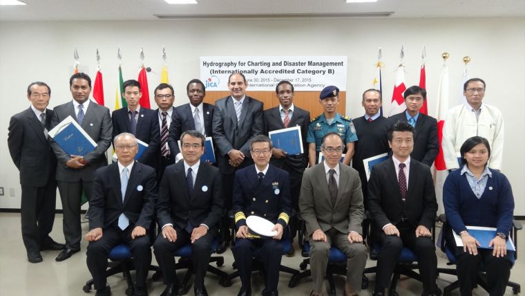
On 17 December 2015, the closing ceremony of the JICA group training course for hydrographic surveying was held at JICA Tokyo International Center in Tokyo, Japan. At the closing ceremony, an IBSC Category B certification for Hydrographic Surveying was presented to 10 training course participants by Vice Admiral Shigeru Kasuga, chief hydrographer of Japan. The participants came from eight countries, namely the Ivory Coast, Egypt, Guyana, Indonesia, Myanmar, the Philippines, Tonga and Vietnam, and completed the course in six months.
By Norio BABA, Akio YAMAMOTO, JHOD, Japan and Tomomi HIRATA, JICA Tokyo, Japan
Considering this training course has now been conducted 45 times since its establishment in 1971, we examine the results and future challenges of this programme in this article.
The present training course is officially entitled “Hydrography for Charting and Disaster Management (Internationally Accredited Category B)” in the Knowledge Co-Creation Program of Japan International Cooperation Agency (JICA), which was conducted as part of the Official Development Assistance of the Government of Japan in cooperation with the Hydrographic and Oceanographic Department, Japan Coast Guard (JHOD). This course has been recognised by the FIG/IHO/ICA International Board on Standards of Competence for Hydrographic Surveyors and Nautical Cartographers (IBSC) as a training course of International Accredited Category B for Hydrographic Surveying since 1988.
Objectives of the training course are firstly to train hydrographic surveyors in developing countries to fulfill the criteria of IBSC Category B to carry out various hydrographic surveying tasks and then to provide basic knowledge and skills to utilise hydrographic techniques and data in other fields such as marine special planning and marine disaster management, especially focused on tsunami disaster.
During the 6 months of the training course, trainees are taught the necessary theory, techniques and skills to plan and carry out hydrographic surveying and to process the obtained data, and then they extend the acquired knowledge and skills through several exercises, such as a one-month field training programme in port and on-board training using a survey vessel of JHOD. The trainees are also taught data processing using GIS software to utilise hydrographic data, and visit several factories and research institutes to see state of the art technology and also visit the damaged areas of the 2011 tsunami disaster in Japan to see restoration activities and disaster management for future disasters.
All trainees stayed at JICA Tokyo International Center (TIC) in Tokyo during most of the training period with the exception of some field exercises and trips. JICA TIC provided a number of services to make the trainees stay in Japan comfortable. It has a clinic, gymnasium and a restaurant offering international cuisine. It also hosts various social events and cultural classes for learning and experiencing Japanese cultures, such as Japanese language, tea ceremony, calligraphy etc. In the past, some trainees climbed to the top of Mt. Fuji, which has been inscribed on the World Heritage list.
All expenses incurred to participate in the training course are covered by JICA, including tuition fees, a return air ticket, accommodations and per diems.
How to Apply
The training course is normally given from the end of June to the middle of December every year for 12 participants. Call for applicants for the course is conducted around March in the designated countries through diplomatic channels with the Government of Japan. These designated countries are determined based on the results of a survey conducted in the previous year to seek countries intending to participate. This survey is called a needs survey and aims to provide appropriate and suitable ones from the various JICA training programmes to meet with the needs of each country. Therefore, those countries wishing to participate in our training course for next year are recommended to reply to the needs survey conducted every summer through the diplomatic channels.
Developments
This training course for hydrographic surveying was established in 1971 as a pilot course in cooperation with JHOD and JICA, given the resolutions of the 4th United Nations Regional Cartographic Conferences for Asia and the Far East in 1964, and it has been conducted regularly since 1972. The JHOD and JICA have continued their efforts to improve the quality of the contents of the training course, taking into consideration the development of technology and needs at the time.
Internal reviews of the training programme have been conducted every year at JICA for improvement and participant reviews have also been conducted twice a year, in the middle and at end of each training course to obtain suggestions from the trainees.
This training course was recognized as a training programme of Category B for Hydrographic Surveying during the 11th meeting of IBSC in Monaco in 1988. Since then, this course has maintained the credential of the IBSC Category B. This course is a rare training programme within the JICA programmes as it is an internationally recognised programme. In 2006, the syllabus of the training course was revised to include the subject of tsunami disaster management, as a result of the Indian Ocean Tsunami in 2004, and it was further revised in 2011 to improve the curriculum on marine environment management and utilisation of GIS technology.
The JHOD introduced Airborne Laser Hydrography System in 2003 and Autonomous Underwater Vehicle in 2013. Subjects related to such new instruments were added to the training course in the same year or year after the instruments were introduced.
We plan to use a transportable type of multibeam echo sounder at the field training in the port next year considering its applicability to the developing countries.
Achievements
414 participants from 42 countries have completed the training course so far, and 256 participants received IBSC Category B certification. 30 programmes in 26 countries now provide recognized training programmes for the IBSC Category B. Since the training course has mainly received trainees from the developing world, it has greatly contributed to fostering mid-level hydrographic surveyors in the world. Some participants have been given important posts in the hydrographic or maritime sector in each country, because of the 45-year history of the training course. The training course has also provided trainees with a good opportunity to build a cooperation network with other trainees from different countries by helping each other during the 6 months of the training course in Japan.
Future Challenges
The ODA policy of the government of Japan established in 1992, made it difficult to receive participants directly to our training course if they belonged to a military organisation because all the JICA programmes had been strictly limited to non-military organisations by the ODA policy, even if the cooperation programme had been for peaceful purpose.
However, in the new ODA policy approved by the Cabinet of Japan in February 2015, it was decided that cooperation programmes could be provided to military organisations or its employees depending on the contents and purpose of the cooperation. This new ODA policy made it possible for those who belong to military organisations dealing with hydrographic surveying to apply for our programme.
Many representative organisations of the IHO Member States are military organisations. We hope that many of such organisations will apply for our training course and that it will help to improve their hydrographic surveying capacity.
As mentioned above, call for applicants and needs survey for the training course are done through diplomatic channels. Our training courses sometimes compete with other JICA training programmes in developing countries and in such cases information on the training course doesn’t reach appropriate organisations in that country. In addition, mismatching of the applicants sometimes occurs. In order to avoid such problems, we should advertise the training course to possible participants internationally.
Advancement of technology in hydrography has been very rapid in recent years and a variety of equipment and methods to conduct hydrographic surveying are available. Preparing lectures and training materials for such advanced technology is another challenge for the training course.
We have cooperated to foster hydrographic surveyors in the developing countries for many years. Unfortunately, there were cases in which trained participants left their organisation to seek higher salaries in private companies or sometimes to go abroad. When we select the training participants, we consider the situation in their country. But such job hopping by the trained participants to another country would undo our efforts. It is a fundamental and common problem for international development assistance.
We would like to strengthen cooperation with other programmes and international activities for the effective and efficient implementation of the training course to improve the capacity of hydrographic surveying in developing countries.
Acknowledgements
We would like to express our appreciation to all the lecturers and others involved in cooperating to conduct and develop this training course.
The Authors
Norio Baba has been working on International Relations at JHOD since 2014. He has extensive experience in participating in international cooperation research projects at sea.
Akio Yamamoto is in charge of the practical coordination for the training course at JHOD.

Value staying current with hydrography?
Stay on the map with our expertly curated newsletters.
We provide educational insights, industry updates, and inspiring stories from the world of hydrography to help you learn, grow, and navigate your field with confidence. Don't miss out - subscribe today and ensure you're always informed, educated, and inspired by the latest in hydrographic technology and research.
Choose your newsletter(s)


