Discovering the True Nature of the Mid-Atlantic Ridge: Part I
Prior to the mid-19th century, the floor of the world ocean was virtually a clean slate. Nothing was known of the bottom of the deep sea with the exception of a few sporadic soundings. In the early 1850s, this began to change as Matthew Fontaine Maury obtained use of one small ship, the USS Dolphin, and sent it out on two expeditions, one in 1852 under Lieutenant Samuel Philips Lee and the second in 1853 under Lieutenant Otway Berryman. Apparently one sounding of 1,720 fathoms was by Lee southwest of the Azores Islands, but under Berryman a number of relatively shoal soundings were made north of the Azores. Maury contoured these soundings as a continuous shallow zone and by 1858 had called the area north of the Azores ‘Middle Ground’, the first name for the Mid-Atlantic Ridge (MAR).
Nearly twenty years later HMS Challenger embarked on its famous voyage. Although adding little to knowledge of the MAR in the North Atlantic, on its return voyage it ran a line up the spine of the MAR in the South Atlantic. These soundings led to the first maps showing the continuity of the ridge, first published in 1876 as a preliminary report by Commander T. H. Tizard and Captain Frank Thomson. They called the northern portion of the MAR the Dolphin Ridge, the equatorial part the Connecting Ridge, and the southern part the Challenger Ridge. Two years later, the chief scientist of the expedition, Wyville Thomson, published a modified map version of the MAR in The Voyage of the Challenger: The Atlantic.
Little additional information was obtained about the MAR until the advent of acoustic sounding systems. Between 1925 and 1927, the German research vessel Meteor traversed the Atlantic Ocean from Antarctic regions to the tropics of the North Atlantic. In a grand reconnaissance, it made thirteen cross-ocean transects and collected 67,000 acoustic soundings. Thirteen profiles were produced from this work, which, although not noted, hinted at the existence of a depression associated with the axis of the ridge.
In the spring of 1938, two legendary oceanographic ships, the Woods Hole Oceanographic ship Atlantis and the German vessel Meteor met off the coast of Florida and discussed their research efforts. The scientist in charge of echo sounding on the Meteor was Dr. Gunter Dietrich, destined to become one of the greatest of German oceanographers and a future head of the Institut fur Meereskunde. Information was exchanged and Dietrich reported that he was informed of the seismological exploration work of Maurice Ewing from the Atlantis. Unfortunately, Ewing was not aboard. If Dietrich and Ewing had met at this time, perhaps the history of the exploration of the Mid-Atlantic Ridge would have been substantially altered.
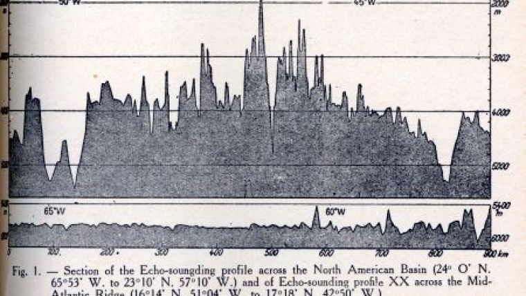
The meeting with the Atlantis occurred on the last expedition of four that Dietrich made on the Meteor between 1935 and 1938. The Meteor traversed the Atlantic four times during the 1938 expedition including a diagonal line from the English Channel to Puerto Rico and three profiles designated Meteor profiles XX, XXI, and XXII. On the initial diagonal, Dietrich directed the Meteor to run a dogleg pattern in the vicinity of the MAR axis such that it was traversed three times between latitudes 27 18 N and 23 25 N. On profile XX, the center of the Mid-Atlantic Ridge was crossed at approximately 16 46 N, profile XXI at 23 50 N, and profile XXII near 30 N.
Following the completion of the cruise, Dietrich wrote a four-page article as part of a larger report on the 1938 German North Atlantic Expedition. This larger report was published in the Annalen der Hydrographie und Maritimem Meteorologie in January 1939 under the title ‘Bericht uber die zweite Teilfahrt der Deutschen Nordatlantischen Expedition des Forschungs- und Vermessungsschiffes Meteor: Januar bis Juli 1938.’ Dietrich’s sub-report was titled ‘Einige Morphologische Ergebnisse der Meteor -FAHRT, Januar bis Mai 1938’. In an English translation of his sub-report, it was titled ‘Some Morphological Results of the Cruise of the Meteor January to May 1938’ and published in the Hydrographic Review in 1939. Accompanying this article were two illustrations. The first was a spectacular cross-section of the crest of the ridge showing a remarkable depression in its center; the second was of his interpretation of parallel ridges and troughs determined along his dogleg profiles.
In his essay, Dietrich reported the following: “… in Profile XX, the sea bottom in the middle of the Mid-Atlantic Ridge drops from a peak height of 1,930m to 4,790m… within a distance of 21 kilometres... A certain similarity in the succession of deep depressions is shown with Profile XX and the previous northernmost Meteor profile of 1927. Such striking depressions in the Ridge occur also in the other five Meteor profiles, the most impressive of which is in Profile XXI…” The six profiles noted, which spanned over 10 degrees of latitude, referred to the three diagonal cuts and three ESE-WSW profiles obtained on the 1938 trip. Although using the terminology ‘striking depressions’, Dietrich was the first to declare he had traced the continuity of what has become known as the MAR rift valley. (It is noted that, like later investigators, he interpreted two deeps that were associated with the Kane Fracture Zone as being two of his ‘striking depressions’.)
Dietrich went on to say: “On the basis of the sounding profiles on the Ridge, we are enabled to take a stand with regard to the problem of morphology of the ocean. That is – is it possible to find a certain correlation of form in the continuous up-and-down of the ocean bottom in the region of the Ridge between the profiles? In other words, are we dealing here with a confused and unrelated rise or with a Ridge which can be resolved into a series of more or less parallel trains of undulations?” He refers to the earlier work of Theodor Stocks and George Wust in studying Meteor profiles from the 1925-1927 expedition who thought it appeared possible, but not practicable. Because Dietrich had surveyed the portion of the ridge on diagonal lines as noted above, he stated “The soundings taken… [by the Meteor in 1938] over this Mid-Atlantic Ridge appear to present this question in a new light… there appears to be a meridional correlation between the forms. Nine continuous undulating trains may be correlated in these three traverses, although the nature of the relationship is very different in individual cases…” Dietrich had interpreted the top two of his dogleg segments correctly, but the third crossed the Kane Fracture Zone causing a misinterpretation of his data.
World War II intervened during which Dietrich served as an oceanographer in the German navy and did not return to academia until 1950. His short paper that had large ideas was ignored by the ocean science community for nearly 10 years. In 1947, Maurice Ewing made his first expedition to the Mid-Atlantic Ridge. He had recently recruited Bruce Heezen to join his group. Heezen thought he was going to join the cruise, but Ewing instead detailed him to search out documents and references relating to the Mid-Atlantic Ridge. Ewing instead brought along Ivan Tolstoy to conduct echo sounding operations.
Heezen’s recollection of this job is included in H.R. Frankel’s work, The Continental Drift Controversy : “I looked up, in their rather good cross index catalogue, subjects such as the Mid-Atlantic Ridge, the Atlantic Ocean Floor … And the principal thing I ran into was a full volume of the Geologische Rundschau … and they devoted about a three or four hundred page issue to the Atlantic Ocean. This was probably the most significant [collection of] papers I found. Also, I found very skimpy references to some work done by the Meteor in the late thirties in the North Atlantic….”
These ‘skimpy references’ apparently related to Dietrich’s paper as that is the only late thirties reference to Meteor work found by this author in the works of Ewing, Heezen, or Marie Tharp, and that only twice. The following year Ewing was sole author of the National Geographic article ‘Exploring the Mid-Atlantic Ridge’. In this article Ewing echoed Dietrich: “Would the ridge be just a chaos of peaks or would it follow some understandable pattern? At first the topography seemed the wildest confusion, but as we studied more and more profiles a definite pattern began to emerge.” However, Ewing’s question had already been answered by Gunter Dietrich in 1939: “However, the echo sounding profiles show definitely that there are no closed massive Ridges, such as they necessarily appear on the small scale bathymetric charts. The confused and tangled mass of crests and valleys in the Mid-Atlantic Ridge can be resolved into a series of approximately parallel trains of undulations rising from the ocean bottom…”
The 1947 Atlantis cruise also discovered a deep valley that Ewing described: “The combination of steep slope and deep ditch suggests that the feature may be a fault scarp and rift valley – a zone of slippage between earth masses – and that earthquakes may have occurred there in historic times.” This was the first time that Ewing referred to a rift. He would not do so again in print for nearly ten years. He was correct in all but calling it a rift - the fault scarp and rift valley turned out to be the east-west trending Atlantis Fracture Zone, later incorrectly interpreted as a rift valley by Heezen and Tharp.
In 1949, Tolstoy and Ewing published North Atlantic Hydrography and the Mid-Atlantic Ridge in the Bulletin of the Geological Society of America. Dietrich’s paper is included in the bibliography although no reference is made to his ‘striking depressions’. Tolstoy and Ewing produced a map of the area surveyed in 1947 supplemented by two additional cruises. The location of the Great Meteor Seamount is shown with a question mark indicating that Tolstoy and Ewing had reviewed Dietrich’s paper, as prior to 1949 it had only been mentioned in Dietrich’s paper where it occurred directly above the Profile XX graphic. Tolstoy’s map correctly showed the parallel structure of the various ridges and troughs in the vicinity of what is today called the Atlantis Massif. He also published a detailed map of the east-west ‘trough’ discovered in 1947. Although minimal indication of the median valley of the Mid-Atlantic Ridge is shown, it was not identified as such. Thus ended the 1940s. The next issue will investigate continued mapping of the ridge in the 1950s.

Value staying current with hydrography?
Stay on the map with our expertly curated newsletters.
We provide educational insights, industry updates, and inspiring stories from the world of hydrography to help you learn, grow, and navigate your field with confidence. Don't miss out - subscribe today and ensure you're always informed, educated, and inspired by the latest in hydrographic technology and research.
Choose your newsletter(s)


