Embarked on Tsunami Disaster by Hydrographic Offices
International Workshop on Tsunami Inundation Mapping
An International Workshop on Tsunami Inundation Mapping was held in Tokyo, Japan on 25-26 November 2015, aiming to improve the capacity of Hydrographic Offices (HOs) in East Asian countries on the Tsunami Inundation Map (TIM). TIM is an important tool in increasing public awareness and making countermeasure plans for an expected tsunami disaster. HOs are expected to contribute to the development of the TIM in their own states, because bathymetric information is essential for this. This event was the first of its kind in the international hydrographic community.
By Hideki KINOSHITA and Norio BABA, JHOD, Japan
The Indian Ocean tsunami, triggered by the earthquake off the west coast of Sumatra, Indonesia in December 2004, caused tremendous damage along the coastal area of Indonesia and other states in the Indian Ocean, reportedly killing 230,000. The tsunami generated by the Great East Japan Earthquake in March 2011 also caused huge damage along Japan’s northern Pacific coast. In this disaster, 16,000 people were reportedly killed and a tsunami run-up of 40m was recorded.
In another disaster caused by sea level rise, storm surges generated by the Haiyan typhoon (Yolanda in the Philippines) caused extensive damage on the Pacific coast of the Philippines in November 2013, killing at least 6,300 people.
The marine disasters related to sea level rise, such as tsunamis and storm surges, have been common threats to the coastal states in the Asia and Pacific regions for many years and those disasters have sometimes caused serious damage to coastal states, depriving many people of their lives and devastating the local economy and environment.
Tsunami Inundation Map
A Tsunami inundation map (TIM) is an important tool in increasing public awareness and developing countermeasure plans for stakeholders regarding tsunami disasters. A TIM maps inundation areas, evacuation sites and evacuation routes together with other useful information. Techniques and knowledge to develop the TIM can be applicable to other marine disasters related to sea level rise, such as storm surges.
To develop the TIM, bathymetric information is essential to estimate the tsunami propagation and inundation area. Hydrographic Offices (HOs) are expected to contribute to the development of the TIM in each state, because of their expertise in conducting hydrographic surveys and compiling collected information into nautical charts.
However, no capacity building activities involving TIM, including workshops, have ever been conducted in the international hydrographic community.
A questionnaire survey on TIM was conducted by the Hydrographic and Oceanographic Department, Japanese Coast Guard (JHOD) before the workshop to gain knowledge of the situation and the needs regarding TIM among the members of the East Asia Hydrographic Commission (EAHC). As a result of the questionnaire survey, it became clear that primary responsibility for TIM had been taken over by other organisations and not the the hydrographic offices in almost all the EAHC member states, while almost all the states that replied had developed their own TIM. The HOs in those countries had in some way supported the development of TIM by providing bathymetric information and tidal information. But they also raised the necessity of sharing experiences and learning more about the techniques and knowledge involved with TIM and also of strengthening cooperation with other organizations.
International Workshop
The International Workshop on Tsunami Inundation Mapping was held by JHOD in cooperation with UNESCO/ International Oceanographic Commission (IOC) Tsunami Programme and Port and Airport Research Institute (PARI), Japan, in Tokyo, Japan on 25 - 26 November 2015, as part of the 2015 East Asia Hydrographic Commission (EAHC) Capacity Building Programme using the International Hydrographic Organization (IHO) Capacity Building fund.
The objectives of the workshop were to improve the capacity of HOs mainly in the East Asian states for the development and utilization of TIM and to discuss the way forward in sharing the latest technology, knowledge, experiences and challenges among the participants.
The workshop programme was designed to cover a number of aspects, ranging from technical theories on the development of the TIM to utilization of the TIM with reference to the TIM of Kamakura City, Japan, as the practical case.
The workshop was attended by 45 people from 9 states.
Prof. Kenji SATAKE, from the University of Tokyo, gave a keynote presentation with the title of “Tsunami generation and propagation”. He said that in two recent decades, tsunami disasters involving a large number of casualties occurred almost every year.
The Japanese Meteorological Agency explained the international tsunami warning and mitigation system under the UNESCO/IOC, and how the 2004 Indian Ocean Tsunami accelerated the establishment of the tsunami warning systems around the world. The Tsunami Warning System has now been established in the Indian Ocean, Caribbean Sea, the North East Antarctic Ocean and the Mediterranean Sea, in addition to the Pacific Ocean.
Dr. Takashi TOMITA, Port and Airport Research Institute (PARI), gave a presentation on the techniques of TIM entitled 'Guidelines for the Development and Utilization of the Tsunami Disaster Management Map'. As keys for tsunami hazard mapping, he said that results of tsunami numerical simulation depend on the accuracy of the numerical models employed as well as bathymetric and topographic data, and we should understand and estimate damage and disasters caused by possible tsunamis, and then ensure that certain groups of people are well prepared for them, and develop cities resistant and resilient to them.
Case studies on Natural Disaster and Remote Sensing were introduced by the Japanese research company, PASCO, with reference to some examples including the typhoon in the Philippines and floods in Thailand. The latest survey technology of airborne laser bathymetry and Satellite Derived Bathymetry were also introduced by PASCO and JHOD respectively at the workshop.
A presentation on Public Awareness and Collaboration for Disaster was given by Dr. Anawat SUPPASRI, International Research Institute of Disaster Science (IRIDeS), Tohoku University, Japan. From the lessons learnt from the disasters in the past, such as the 2004 Indian Ocean tsunami and the 2011 Japanese tsunami, he highlighted the importance of understanding the generation mechanism of each disaster, the necessity to prepare for unexpected events and more accurate hazard maps concerning uncertainty, and also that the problems during evacuation are the most important topics to be solved.
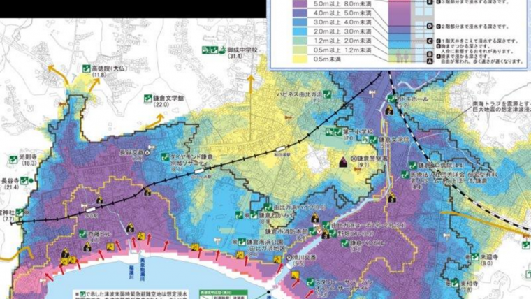
As practical examples, the activities of Kamakura city, and theTsunami Information Map by JHOD were introduced. Kamakura city has built a basic concept of “self-help and helping each other” for the tsunami disaster and it has requested local people to be the first to evacuate, because visitors, including foreigners, would then follow. Situations and challenges among the EAHC members were also reported by representatives from the Philippines and Indonesia before the discussions.
After the series of presentations, Mr. Hideki KINOSHITA, JHOD, led discussions on how the capacity on development of the inundation map in the region had been improved, categorizing the discussion points into three stages, namely the preparation stage, the information collection stage and the utilization stage of the tsunami inundation map.
Outcomes
Through the workshop the participants recognized that:
- TIM is a very useful and essential tool in increasing public awareness and developing countermeasure plans not only for a tsunami but also for a storm surge,
- Hydrographic Offices are strongly encouraged to provide high quality coastal bathymetric information coupled with the land elevation, which is essential information for the accurate estimation of tsunami propagation and inundation, and
- It is important to strengthen collaboration among the national organizations, agencies and institutions for promoting the development and utilization of TIM.
The workshop also confirmed that Hydrographic Offices could play a leading role in many parts of the development and utilization of TIM in each state.
The workshop acknowledged that various activities for TIM have been conducted internationally, such as the IOC Tsunami Programme, Asia-Japan Transport Partnership and Regional Integrated Multi-Hazard Early Warning Systems for Africa and Asia (RIMES), and also recognized that further collaboration in international activities and active participation in the international activities by each country should be encouraged.
The workshop then agreed that further capacity building activities on Tsunami Inundation Mapping could be requested to improve the capacity of the Hydrographic Offices.
Field Study
A field study for the workshop participants was conducted on the following day of the workshop.
The participants visited the Port and Airport Research Institute (PARI) to see its research facilities and the latest studies on tsunamis. As a result of a tsunami flume experiment, they also saw the high energy of a tsunami even at a height of 50 centimetres.
After the PARI, they explored Kamakura city, comparing the tsunami inundation map of Kamakura city and an actual row of stores and houses on the streets. They understood the importance of the signs for evacuation.
Way Forward
We learned through the workshop that it is important both to improve our capacity in developing the inundation map for tsunamis or storm surges and to maintain our continuous efforts in improving public awareness and preparedness for disaster, utilizing the inundation map in peace time in order to further reduce damage caused by future tsunamis or storm surges.
We hope the workshop will serve as a good example for conducting similar workshops in other regions.
Acknowledgements
I would like to express my appreciation to all the lecturers, participants and my staff for their active cooperation in the workshop.
More Information
- Port Technology Group, ASEAN-Japan Transport Partnership, 2008. Guidelines for the Development and Utilization of the Tsunami Disaster Management Map
The Authors
Hideki Kinoshita has been the Director of the International Affairs Office in the Hydrographic and Oceanographic Department of the Japanese Coast Guard since April 2014. Before that, he devoted himself to the rehabilitation of damaged areas following the tsunami disaster in 2011 and directed hydrographic services in those damaged areas as the Head of the Regional Hydrographic Office of the Japanese Coast Guard.
Norio BABA has been working on International Relations in JHOD under the supervision of Mr. KINOSHITA. He worked extremely hard on the workshop programme.
Email: [email protected]

Value staying current with hydrography?
Stay on the map with our expertly curated newsletters.
We provide educational insights, industry updates, and inspiring stories from the world of hydrography to help you learn, grow, and navigate your field with confidence. Don't miss out - subscribe today and ensure you're always informed, educated, and inspired by the latest in hydrographic technology and research.
Choose your newsletter(s)


