SHOM’s Coastal Mapping Project to Use Global Mapper
The Service Hydrographique et Océanographique de la Marine (SHOM, France) has selected Global Mapper for its Litto3D project. The goal of this programme is to create a seamless, high-resolution elevation model incorporating both bathymetric and topographic coverage for the entire coastline of France as well as French Overseas Territories. The inclusion of Global Mapper in the project planning and data-processing tasks is a fitting testament to the strength and versatility of the software.
Operating under the administration of the French Ministry of Defence, SHOM, utilises both airborne Lidar and multibeam data collection techniques in the Litto3D project. As a result, enormous quantities of raw data are generated covering the swath of coastline from 10 metres above to 10 metres below sea level and extending at least 2 kilometres inland.
GIS Analysis
Blue Marble's geospatial data manipulation, visualisation, and conversion solutions are used worldwide by thousands of GIS analysts at software, energy, mining, civil engineering, surveying and technology companies, as well as government agencies and academic institutions.
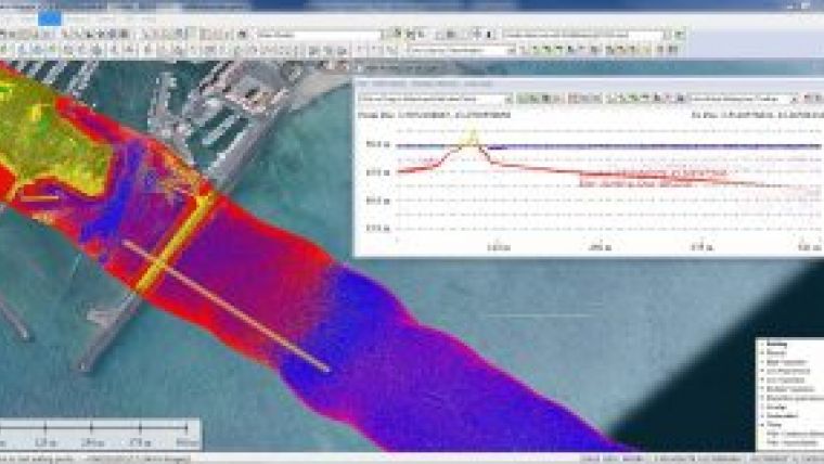
Global Mapper provides value to the programme throughout all phases of the project; from mission planning to field activity management to data processing to file export and delivery. Initially, Global Mapper provides a platform for visualisation of the project area and for the establishment of optimal flight paths. In the post-collection phase and in tandem with an array of dedicated tools, Global Mapper is employed in the visualisation and processing of the raw point cloud files to guarantee quality and coverage. Global Mapper’s intuitive scripting process ensures that many routine and time-consuming procedures are streamlined saving time and ensuring consistency.
Point-cloud Processing
To supplement Global Mapper’s point cloud processing capabilities, the team is also employing the Lidar Module, a set of tools for performing advanced editing and analysis of Lidar data. The Module’s automatic ground point detection and reclassification process creates a more precise model of the nearshore seafloor, effectively identifying anomalies in the surface and allowing straightforward filtering and cleanup of the data. While primarily intended for topographic applications, technicians at SHOM are using this tool for bathymetric analysis.
Data generated by the Litto3D project is accessible through an online viewer and through a direct download of the files.

Value staying current with hydrography?
Stay on the map with our expertly curated newsletters.
We provide educational insights, industry updates, and inspiring stories from the world of hydrography to help you learn, grow, and navigate your field with confidence. Don't miss out - subscribe today and ensure you're always informed, educated, and inspired by the latest in hydrographic technology and research.
Choose your newsletter(s)


