SoundPix Real-time 3D Seabed Mapping Solution
Kraken Sonar Systems (Canada) has released SoundPix, designed to work with autonomous underwater vehicles (AUVs), unmanned surface vehicles (USVs) and conventional survey launches. The solution tightly integrates Kraken's real-time synthetic aperture sonar (SAR) signal processing with the data processing and mapping application, CARIS Onboard. SoundPix enables near-real-time, ultra-high-resolution imaging and 3D mapping of the sea floor.
With the SoundPix workflow, Kraken's Synthetic Aperture Sonar signal processor outputs processed sonar data in real time to an embedded version of CARIS Onboard. The software then automatically converts data as it becomes available and applies a range of predetermined corrections to generate a terrain model or mosaic. This allows for early visualisation of sea floor characteristics and supports an environment of improved efficiency. By the time the survey platform has completed its mission a fully georeferenced and processed dataset is available for final quality control and incorporation into information products. The system is a force multiplier allowing multiple datasets to be processed quickly and consistently.
Interferometric SAS
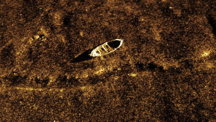
In addition to reflectivity images, SAS can produce highly detailed topographic maps of the sea floor by detecting the angle of arrival of seabed echoes coming from a given range bin. In a configuration known as Interferometric SAS (INSAS), two vertically separated arrays produce bathymetric maps that are exactly co-registered with the corresponding SAS images. This combination of synthetic aperture processing and interferometry solves the problems of limited resolution and coverage rates encountered with conventional swath bathymetric sonars and multibeam echosounders. When the InSAS bathymetric resolution approaches that of the corresponding SAS image, it becomes possible to overlay the reflectivity and topography to create a true 3D picture of objects on the seabed.
AquaPix produces real-time, high-resolution, three-dimensional (3D) digital terrain models of the sea floor with bathymetric resolution up to 5cm x 5cm and simultaneous co-registered imagery resolution as fine as 3cm x 3cm.
With high resolution INSAS it is possible to use image fusion techniques, such as those provide by CARIS solutions, to combine the bathymetric data with the reflectivity data to create a true 3D representation of objects on the seabed. The ability to generate centimetre-scale resolution in all three dimensions has the potential to provide significant improvements in the detection, classification and identification of small seabed objects.

Value staying current with hydrography?
Stay on the map with our expertly curated newsletters.
We provide educational insights, industry updates, and inspiring stories from the world of hydrography to help you learn, grow, and navigate your field with confidence. Don't miss out - subscribe today and ensure you're always informed, educated, and inspired by the latest in hydrographic technology and research.
Choose your newsletter(s)


