Z-boat 1800-RP to Survey in Remote Locations for University of Washington Tacoma
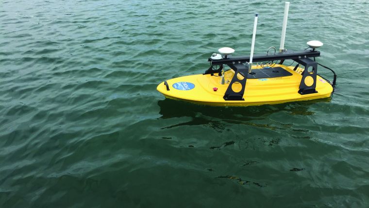
Teledyne Oceanscience has shipped a custom Z-Boat 1800-RP to the University of Washington Tacoma. Dr Dan Shugar, assistant professor of geoscience at the University of Washington Tacoma, will be heading to two remote locations in Alaska and Canada this summer with the new Z-boat. The custom integration for the University of Washington Tacoma included the rugged Z-Boat 1800RP, Teledyne Odom Hydrographic MB2 Multibeam, Teledyne RD Instruments RiverPro ADCP, a camera, IMU and onboard computer.
Dr Shugar will be heading in early August to Taan Fiord, an arm of Icy Bay in the rugged St Elias Mountains of southeast Alaska, to study one of the largest landslides in recent decades. The landslide partially covered the terminus of the tidewater Tyndall Glacier, releasing most of the debris into the fjord and triggering a massive tsunami. Shugar’s National Science Foundation-supported bathymetric mapping mission will occur in tandem with a second multibeam sonar mission using the Teledyne Reson T50P lead by Dr. Sean Gulick of The University of Texas at Austin. A better understanding of fjord bathymetry will feed into more accurate tsunami models.
Detailed Mapping of River Bathymetry
In late August, Shugar will be heading to the glacier-fed Slims River in Kluane National Park, Yukon, Canada. Because glacial rivers are often shallow and swift, traditional survey vessels and larger MB2 sonar have not typically been employed. In the Slims River, the Z-Boat and MB2 will be used to map the bathymetry of the river in unprecedented detail. When combined with flow data from the ADCP, Shugar and his students will be able to better understand how velocity and discharge affect river geomorphology.
Teledyne Oceanscience Z-Boat 1800’s ruggedised design is IP67-rated and incorporates a modular deck structure for antennas, cameras, and additional sensor mounting, making this Z-Boat ideal for shallow coastal mapping applications. The ruggedised package features an interchangeable sensor well design by Oceanscience, accommodating a range of instruments including the Teledyne Odom Hydrographic MB1, MB2, and CV100, various Teledyne RDI ADCPs and Tritech Side-scan Sonar. Custom sensor integrations are available. Sensors are easily interchanged from beneath the vehicle. A drone upgrade with waypoint navigation is available to offer laser-straight survey lines and precise positioning for large area or repeating surveys.

Value staying current with hydrography?
Stay on the map with our expertly curated newsletters.
We provide educational insights, industry updates, and inspiring stories from the world of hydrography to help you learn, grow, and navigate your field with confidence. Don't miss out - subscribe today and ensure you're always informed, educated, and inspired by the latest in hydrographic technology and research.
Choose your newsletter(s)


