Lidar Allows Sandy River to be Mapped
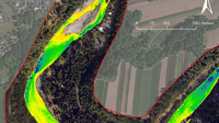
In September 2012, Watershed Sciences, Inc. (WSI) and Dewberry collected airborne topobathymetric Lidar data for the Sandy River in Oregon, USA. These data are being used to map channel and floodplain morphology and to evaluate the effectiveness of RIEGL’s VQ-820-G hydrographic airborne scanner in a Pacific Northwest riverine environment. The shallow river system - including side-channel and off-channel areas that are notoriously difficult to measure using conventional techniques - was successfully mapped using Lidar.
The Sandy River in northwestern Oregon is a shallow river running from Reid Glacier on Mount Hood for 56 miles to the Columbia River and flows through areas of steep terrain and dense forest. The nature of the river makes it challenging for traditional transect or boat-based bathymetric surveys. The RIEGL VQ-820-G sensor was selected for its pulse repetition rate, short pulse width, and narrow beam divergence.
The VQ-820-G was mounted in WSI’s Cessna Caravan and flown at 600 metres above ground level with 50% overlap between flight lines. With a flying speed of 105 knots, 7,000 acres of topo-bathymetric surfaces were mapped in less than 6 hours at a pulse density of 6 points per square metre. Analysis involved post processing and further line-to-line calibration to match collected ground survey data. Laser returns from water were corrected for refraction using software developed by Dewberry that utilised an extracted water surface. A depth model was calculated along with a confidence layer to assess depth penetration, coverage, and accuracy.
The clarity in the Sandy River was measured at a 2 metre Secchi depth on the day of the survey. With RIEGL advertising a depth finding range of 1 Secchi depth, it was expected that the majority of the river channel would be mapped. The mapped area was divided into high and low confidence categories based on density of bathymetric returns. High confidence areas accounted for 83% of the mapped channel and had a vertical accuracy of 0.18 metre RMSE when compared against channel cross section data. However, the accuracy of ground data collection was hindered by difficult wading conditions and GPS masking (terrestrial returns had a 0.03 metre RMSE).
Overall, the project produced encouraging results for the utilisation of small footprint, topobathymetric Lidar for mapping channel floodplains and shallow water river systems. WSI and Dewberry have received strong positive feedback from project partners about the results of the survey and the future opportunities of airborne hydrographic scanning.
Contributing partners for the test project were the Oregon Department of Geology and Mineral Industries, the Federal Emergency Management Agency and Bureau of Land Management.


