The evolution of Dutch hydrography
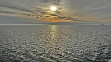
Given the Netherlands’ geographical location, it is unsurprising to find it has a long tradition of hydrography. The lowland, often below sea level, forms a delta where major rivers from...

Given the Netherlands’ geographical location, it is unsurprising to find it has a long tradition of hydrography. The lowland, often below sea level, forms a delta where major rivers from...

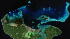
By harnessing capabilities of advanced satellite technology and ever-evolving data analysis, satellite-based mapping (including satellite-derived bathymetry, SDB) offers an efficient, extensible and cost-effective method for mapping water properties, underwater topography...

In the quest to unravel the mysteries beneath our planet’s water bodies, topobathymetric technologies emerge as a beacon of innovation. Among them, Lidar (light detection and ranging) and sonar sensors...
The Danish Geodata Agency, alongside several collaborators, is currently conducting trials on the latest iteration of navigational charts in the Baltic Sea region. This initiative forms part of an EU-funded...

How do you perceive prospects in the hydrographic surveying industry in 2024, compared to the past couple of years? When contemplating the hydrographic sector holistically, which areas of investment do...

The Republic of Cabo Verde, an archipelago located 500km off the west coast of Africa in the Atlantic Ocean, has taken a stride towards improving its hydrographic capacity by becoming...
The UK Hydrographic Office (UKHO) has revised its plan to phase out the production of paper navigation charts. The original plan, announced in July 2022, was to end the production...
By Roosmarijn Haring Safety of navigation is essential for the protection of lives and the environment. This is the basic premise of the United Nations (1974) proclamation entitled SOLAS...
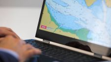
The Norwegian Hydrographic Service (NHS) is conducting a prototype development project for a print on demand service, intending to facilitate chart users ordering updated nautical charts from the Hydrographic Service....
Coastal zones, situated at the intersection of land and ocean, hold immense social, economic and ecological significance. Currently, nearly 40% of the global population resides within 100km of the coast,...
This site uses cookies. By continuing to use this website, you agree to our Cookies Policy. Agree