Revised ECS Standard Published
Special Committee 109 of the Radio Technical Commission for Maritime Services (RTCM) has published the latest edition of its standard for Electronic Chart Systems (ECS). Different to the Electronic Chart...
Special Committee 109 of the Radio Technical Commission for Maritime Services (RTCM) has published the latest edition of its standard for Electronic Chart Systems (ECS). Different to the Electronic Chart...
The Final Draft International Standard (FDIS) for the ECS database Ð ISO 19379 Ð has been approved by an NECSA international vote of thirteen countries. The FDIS version of the...
The American National Standards Institute (ANSI) has published the ECS Database standard, ISO 19379 and this is now available for purchase. In the United States copies of this copyright document...
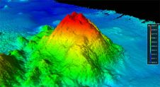
A discovery has come out of the U.S. Extended Continental Shelf (ECS) Task Force mapping efforts in an area of the Pacific Ocean that is one of the least explored...
The Electronic Chart situation has developed in an unexpected way. When the first standards for chart systems were being written, the concentration was on those installations which would become the...

Optimare Sensorsysteme AG, based in Bremerhaven (Germany) has taken delivery of nine operational and planning versions of TheMAP 210 Electronic Chart Systems manufactured by Chartworx Holland BV. Six of these...
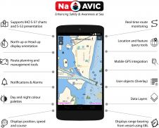
NaAVIC is a free and downloadable electronic voyage application that goes beyond the traditional Electronic Chart System (ECS) app whereby the data, including the ENC information, does not physically reside...

The UK Hydrographic Office (UKHO) has announced it is kickstarting an S-102 Bathymetric Surface sea trial project in collaboration with the Port of London Authority (PLA) and multi-platform piloting solution...
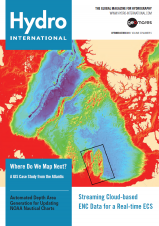
COVER STORY: The front cover of this issue of Hydro International shows the IBCAO grid displaying the Arctic Sea with a black box outlining Chukchi Plateau. The availability of a...
NOAA’s Marine Chart Division (MCD) is currently revising production efforts using an ‘ENC-first’ approach to provide seamless and tiled geographic coverage. Currently, ENC production workflows within MCD require cartographers to...
This site uses cookies. By continuing to use this website, you agree to our Cookies Policy. Agree