The evolution of Dutch hydrography
Given the Netherlands’ geographical location, it is unsurprising to find it has a long tradition of hydrography. The lowland, often below sea level, forms a delta where major rivers from...

Given the Netherlands’ geographical location, it is unsurprising to find it has a long tradition of hydrography. The lowland, often below sea level, forms a delta where major rivers from...
Cartography is about describing the world in the form of maps and diagrams. Classic cartography produces paper maps but nowadays this field also encompasses Geographical Information Systems and the products...
The hydrographic and cartographic community is having to adapt to what is becoming ‘continuous change’. Such changes include new systems, new processes, regulations and an increasingly dynamic digital world. Never...
For two decades, CARIS’ hydrographic production database solution has enabled geospatial data to be managed in a data centric manner, while allowing various types of products to be created and...

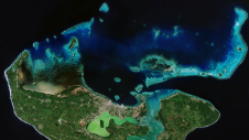
The Republic of Cabo Verde, an archipelago located 500km off the west coast of Africa in the Atlantic Ocean, has taken a stride towards improving its hydrographic capacity by becoming...
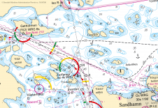
The increasing use of ENCs on SOLAS ships and the envisioned migration towards e-Navigation needs a new view on how hydrographic data is composed for the use by the mariner....
Coastal zones, situated at the intersection of land and ocean, hold immense social, economic and ecological significance. Currently, nearly 40% of the global population resides within 100km of the coast,...
The United Kingdom Hydrographic Office (UKHO) and the Maritime and Port Authority of Singapore (MPA) have announced a new bursary training scheme in Marine Cartography and Data Assessment. Organised jointly...
This site uses cookies. By continuing to use this website, you agree to our Cookies Policy. Agree