Steering shipping towards a sustainable future
Ocean data has a vital but underappreciated role to play as an enabler in shipping’s energy transition. In particular, it can help to unlock the short-term carbon savings that will be essential betw...
Find the hydrographical article you are looking for: filter by article type such as interviews, editorials and features, or filter by date or subject. You can also search the entire Hydro International article archive.

Ocean data has a vital but underappreciated role to play as an enabler in shipping’s energy transition. In particular, it can help to unlock the short-term carbon savings that will be essential betw...

Various attempts have recently been made to expand the scope of research in the maritime field through the convergence of cutting-edge technologies. One example is the remote classification and predic...
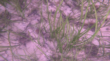
Seagrass meadows play an invaluable role as critical ecosystems that contribute significantly to marine biodiversity, carbon sequestration and coastal protection. In recent years, the importance of th...
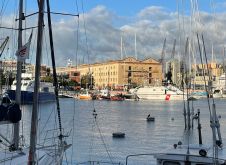
Hydro 2023 took place from 7 to 9 November in the beautiful port city of Genoa in Italy. Organizers of this year’s edition of the hydrographic conference were the International Federation of Hydrogr...
All over the world, surveyors are opting for UAV technologies to advance coastal mapping services. VBW Weight GmbH from Germany and RASA Surveying from the Philippines are professional service provide...
In this article, we examine the evolving landscape of bathymetry with insights from Anders Ekelund, vice president of airborne bathymetric Lidar at Hexagon Geosystems. Beyond mapping seagrass, Ekelund...
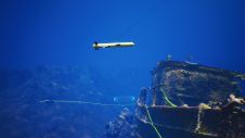
Assets on the seabed, such as offshore wind turbines, natural resource extraction systems and underwater cables, serve as critical subsea infrastructure. To efficiently build, monitor, protect and mai...
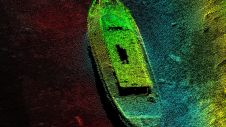
A group of companies recently came together to conduct an offshore multibeam survey of the anchorage near the entrance to Boston Harbor using an autonomous vessel. The surge in autonomous survey vesse...
The position of bathymetric sensors in hydrographic education is beyond discussion, as bathymetry is, was and will continue to be the bread and butter of the hydrographic surveyor. Bathymetric sensors...
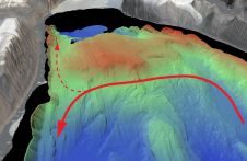
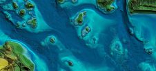
An understanding of the interplay between glaciers and the ocean is needed to improve sea-level rise projections. Seafloor mapping is critical in this pursuit, particularly where the ice sheets of Gre...
Hydro International offers professionals the opportunity to contribute to any forthcoming issue in a practical and informative way, taking the editorial theme into account.
The editorial calendar can be downloaded here.
If you want to contribute, please contact Wim van Wegen, Content Manager of Hydro International.
Contact information
Wim van Wegen
[email protected]
+31 (0)514 561854
This site uses cookies. By continuing to use this website, you agree to our Cookies Policy. Agree