Skansen is a historic area in the city of Trondheim in central Norway and home to the Skansen Bridge, a 52m span bascule railway bridge that opens for marine traffic to access the Trondheim Fjord. The Skansen Bridge was built in 1918 and designed by structural engineer Joseph Strauss, who also designed the Golden Gate Bridge in San Francisco. The displacement of rocks and other objects in shallow waters over time can result in structural integrity issues for bridge piers such as the Skansen Bridge and hazards for vessel traffic, so that regular inspection of the structural integrity is required to ensure safe navigation.
(This article is brought to you by Norbit)
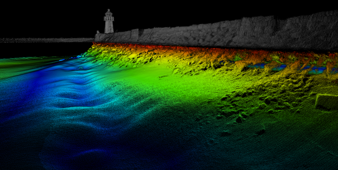
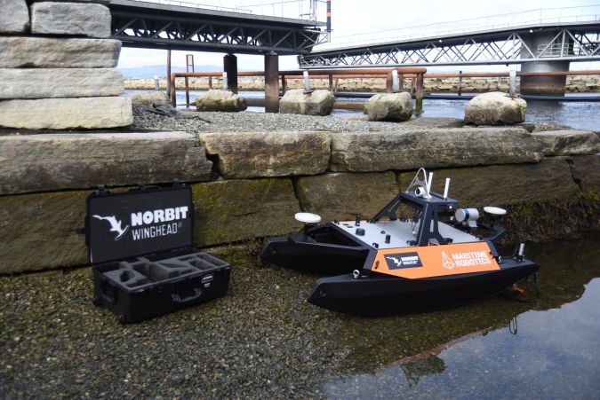
Norbit investigated whether there has been any displacement of the rocks that form the jetty of the Skansen Bridge, performing a multibeam and Lidar survey inspection of the jetty. The devices selected for this project were the Norbit Winghead® i77h, with the integrated Applanix OceanMaster GNSS/INS system, the Norbit iLiDAR, the Norbit Sound Velocity Profiler and the Maritime Robotics Otter unmanned surface vehicle (USV). With this novel combination of the Winghead and Otter USV in place, the survey could be controlled remotely from the Skansen Bridge. Easy-to-use USV control software was used to plan the survey and collect the data, all of which was time-synchronized internally. The USV used RTK GNSS positioning, which employs internet-based corrections, meaning that no cables, base stations or radios are required, reducing costs and complexity in terms of project management for surveys.
About the Norbit Winghead and the Otter USV
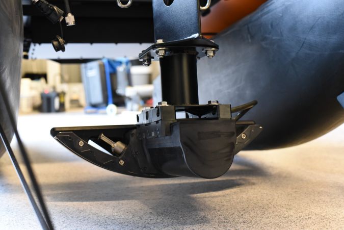
Launched in July 2020, the Winghead is the first cylindrical ultra-high-resolution bathymetry sonar on the market, providing 0.5 x 0.9°beam width at 400kHz and with a HD beamformer, providing 1,024 beams per ping. It incorporates a high-performance integrated GNSS/INS system with a sound velocity probe, small form factor and low power consumption. Despite its power, the Winghead is the most compact ultra-high-resolution multibeam survey system currently available, and all its components fit in a single pelican case. The Otter USV, developed by Maritime Robotics, is a versatile, small footprint USV designed for seabed mapping and monitoring applications in sheltered waters, harbours, lakes and rivers. Lightweight and portable, the Otter is easily transported in a van, offering best-in-class endurance for its size, operating up to 20 hours at 2 knots. The Otter carries a built-in AutoCast winch for SVP casts and its vehicle control software includes planning functionality for automated launch and recovery of the winch, as well as mission planning for running autonomous vehicle missions. The entire system is designed for rapid mobilization and deployment from a slipway, with all sensors pre-mounted on the USV. Survey offsets are fixed and known, which means that no further measurements are required to produce the survey data.
Norbit’s curved array technology allows the beams to be steered electronically up to the waterline without having to physically rotate the sonar, which is ideal for combined multibeam and Lidar surveys and allows a seamless transition between the two data types. Curved arrays produce narrower beams (higher resolution) across the entire swath compared to an equivalent flat array system. The combination of 1,024 beams and 0.5°beam widths provides ultra-high-resolution point cloud data and facilitates the detection of small targets such as rocks, ropes, chains, anchors or other objects that may be hazardous to navigation in shallow harbours.
Achieving Efficiencies and Leveraging Advanced Technology
This project is the first to utilize the Winghead, Otter and iLiDAR integrated survey system. Combining the Norbit Winghead and iLiDAR with the Otter USV enables surveyors to obtain more accurate, high-resolution data, and to minimize the survey mobilization time. The combination of Norbit multibeam and Lidar technology enables the collection of point cloud data above and below the waterline from a portable, unmanned platform, as demonstrated near the Skansen Bridge. This leverages the benefits of USVs that can operate in shallow, hard-to-reach areas where it is difficult for conventional survey vessels to navigate. Anybody wanting to increase the efficiency and accuracy of their hydrographic surveys and bridge inspections should keep an eye on the possibilities for this next generation approach to shallow water surveying.
Get in Touch with Norbit Subsea
Norbit Subsea designs and develops wideband multibeam sonars for hydrographic applications, forward-looking applications and advanced subsea leakage detection. Solutions are based on the latest developments in analogue and digital signal processing and products provide wide coverage monitoring combined with high sensitivity and accuracy. Reach out to Norbit Subsea today at [email protected] to discuss the opportunities that the Winghead-equipped Maritime Robotics Otter USV could bring to your enterprise.