Advancements in Area-based Imagery Processing
An Integrated Geocoder Delivers a Streamlined Workflow and New Capabilities
For many years the focus has been on collecting and processing the first bottom return of multibeam sonars. However, the acoustic backscatter acquired by multibeam sonars, as well as sidescan sonars, also carries important information about the sea floor and its physical properties.
One necessary step towards this characterisation is the creation of more consistent and reliable mosaics of acoustic backscatter. To create the final backscatter map, it is necessary to carry out certain corrections on the backscatter. Following last month's interview with CARIS founder Dr Masry, here we focus on a tool that has been introduced for this purpose: Mosaic Editor. This tool integrates a Geocoder into a bathymetric data cleaning and validation tool: HIPS and SIPS. This provides users with a seamless bathymetric and imagery processing experience.
New Approach
A fundamental shift has taken place in the correction of bathymetric data with SIPS, moving from a line-based to an area-based processing approach. Key to this shift is the Mosaic Editor. It incorporates the backscatter processing and sediment analysis capabilities of an integrated Geocoder engine, with SIPS. Great care has gone into the design of the Mosaic Editor user interface.
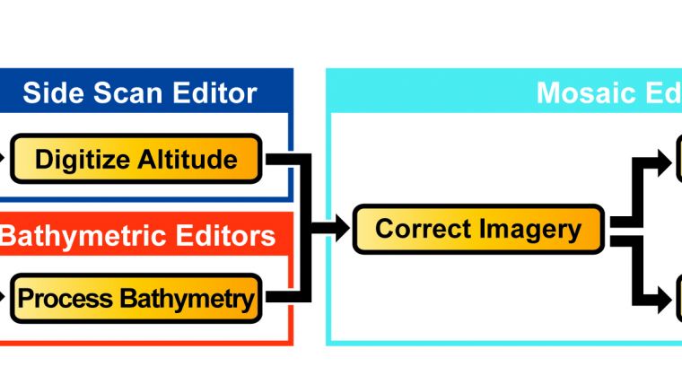
The workflow is straightforward. After processing bathymetric data, users will open Mosaic Editor to process their imagery, be it side-scan, beam-averaged intensities or time series per beam data. Due to the sophistication of Mosaic Editor and the accuracy of correction by the embedded Geocoder engine, processing any of these imagery sources is surprisingly simple and produces remarkably uniform results. After this, users may create and edit mosaics or use the sediment analysis tool to analyse the sediment angular response.
A major change for SIPS users is that the raw imagery is processed directly into georeferenced backscatter rasters (GeoBaRs). GeoBaRs allow for initial quality assessment in geo-referenced space, and interactive mosaic creation and editing. It is possible to have many GeoBaRs per survey line; a useful feature when dealing with file formats that can have multiple sources of imagery data.
Efficient QC
The array of automated geometric and radiometric corrections in Geocoder is the perfect complement to the advanced manual correction tools in SIPS. By initially processing the survey imagery using the Geocoder engine, the user may quickly produce a detailed mosaic. If there are areas of concern arising from inspection of the mosaic, the user may elect to examine the data more closely. The georeferenced, corrected data may provide the necessary clues to reprocess some or all of the data. If a deeper analysis is required, a time-based, waterfall-style editor is integrated into Mosaic Editor.
Creating and Editing
The introduction of GeoBaRs provides significant new opportunities for creating mosaics in SIPS. Due to this conformity, mosaics can be composited using processed data from any number of related surveys, independent of equipment type or logging format. Additionally, mosaics may be created from GeoBaRs of different resolutions, placing no limitations on their usage.
Sediment Analysis
One of the most innovative aspects of Geocoder is its sediment analysis capabilities. This is made possible by the accurate removal of acquisition artefacts found in the source data and by the sediment angular response models built into Geocoder. These models were implemented in Geocoder by Dr Fonseca and are based on years of published research in this area. This is a crucial point, for it is these models that drive the analysis, rather than any sort of ‘curve-fitting' algorithm. This powerful tool, known in Geocoder as angular range analysis (ARA), is realised in SIPS as the sediment analysis tool (SAT).
This tool is used primarily to analyse corrected backscatter returns. In its current implementation, GeoBaRs are divided into user-defined, regularly spaced patches for port and starboard returns. For any given patch, the average signal response is shown in the SAT graph window. When analysing, the signal traces are joined by the total backscatter model trace as the Geocoder ARA engine attempts to classify the response. The determined average grain size is cross-referenced to a look-up table in order to provide the textural response. This classification table is configurable in the SIPS implementation. The analysis also provides a confidence value as well.
In the advanced mode of the SAT, the user has the freedom to interact with the model, adjusting the parameters and seeing the graph's backscatter traces update automatically. This mode is useful for experts who may wish to specifically configure the Geocoder responses, or who may wish to manually investigate certain angular response properties.
Embedding Geocoder
This unique approach of using Geocoder as an embedded engine, rather than a standalone application as depicted in Figure 6, has proven to have significant merits. First among them is that it has proven to be significantly faster during benchmark testing. Necessary data, such as navigation and processed depths, are automatically routed to the embedded Geocoder engine when processing imagery rather than being read from the source data file.
Second, GeoBaRs are built on BASE surface technology and thus provide benefits such as data caching, multiple data layers and, most importantly, scalability.
Third, a notable advantage in some environments has been the ability to create, share, recall and apply process templates for performing work in SIPS. This allows for routine operations to be automated, and also permits organisations to standardise operations and workflows.
Conclusions
The strengths of Geocoder are certainly in its array of detailed backscatter corrections and its accurately modelled sea-floor characterisation algorithms. The challenge then is to blend these capabilities into a coherent workflow, design a clear yet powerful user interface, and provide the scalability, stability and efficiency needed by organisations of any size. CARIS has succeeded in meeting this challenge and a new benchmark in backscatter processing has been set.
Acknowledgements
Geocoder was developed by Dr Luciano Fonseca and is licensed to CARIS by the University of New Hampshire.
Alexander MacDonald, B.Sc.Eng (Electrical) is a Development Manager at CARIS where he has been leading the revitalisation of CARIS SIPS. He has brought unique insight and valuable experience to this role, having spent a number of years in both the Aerospace and Electronics Manufacturing industries. He also played a key part in helping CARIS to achieve ISO 9001:2000 certification.
More Information
- Fonseca, L., and Mayer, L.A., 2007: Remote estimation of surficial seafloor properties through the application Angular Range Analysis to multibeam sonar data. Marine Geophysical Researches, 28 (2), p. 119-126.
- Fonseca, L., and Calder, B., 2005: Geocoder: an efficient backscatter map constructor. Proceedings of the US Hydrographic Conference 2005; San Diego (CA).
- MacDonald, A.J., and Collins, C., 2008: Taking Geocoder to Work: Making Geocoder part of your Daily Routine. Proceedings of the Shallow Survey Conference 2008; Portsmouth (NH).
- Masry, M., and Collins, C., 2008: Scaling Bathymetry: Data handling for large volumes. Proceedings of the Shallow Survey Conference 2008; Portsmouth (NH).

Value staying current with hydrography?
Stay on the map with our expertly curated newsletters.
We provide educational insights, industry updates, and inspiring stories from the world of hydrography to help you learn, grow, and navigate your field with confidence. Don't miss out - subscribe today and ensure you're always informed, educated, and inspired by the latest in hydrographic technology and research.
Choose your newsletter(s)


