An Adaptable Survey Platform for Shallow Water
Bathymetric Charting of Nearshore, Harbour, Estuary and River Settings
High-resolution bathymetry and water quality surveys of shallow shelf and inland water bodies are an increasingly necessary part of environmental management with climate change pressures. This paper describes a new method for data acquisition using a small, stable, adaptable, single-operator survey platform.
Development and natural (climate related) changes are placing an ever increasing pressure on our coasts, shallow marine shelves, estuaries, rivers, harbours and inland water bodies. In Europe these pressures have been recognised and attempts made to address the impacts under legislation such as the Water Framework Directive, which seeks to classify all water bodies by their health and in so doing to place obligation on Member States to monitor this for both positive and negative impact. Surveying these water bodies, which are typically shallow, often turbid, have poor access and occur adjacent to both urban and rural settings, is challenging. Obligations for survey often follow necessity such as maintaining shipping lanes, preserving water quality and providing defence to increasing sea levels. There have been numerous recent developments that attempt to address some of these survey needs and in particular to provide high-resolution maps of the bathymetry of shallow-water bodies. For example, Pfennigbauer and Steinbacher (2012) used a high-resolution laser scanner from an airborne platform to map inland rivers while Geen et al. (2010) have demonstrated a wide variety of alternative platforms and Neal et al. (2012) have more recently described the use of remote control boats. Here we present an alternative method for providing a high-resolution survey solution.
The drive for the design of a high-resolution, adaptable survey system came from a need to meet research requirements for long-term monitoring of the dynamic estuaries on the east coast of the UK where tidal currents are often strong and the weather can often be far from ideal. The primary function for the platform was to record bathymetry with a secondary goal of platform adaptability for acquiring high-resolution sub-bottom seismic and recording water properties. It was also a requirement of the survey platform with sensors that it could be rapidly deployed and that it has a responsive mode to events such as storms and floods. In addition to the research-driven requirements of the system, there were a number of operational factors and cost constraints that were considered in the design such as ease of deployment, minimal calibration between deployments, minimal operational personnel, real-time monitoring of records and a quick turn-around in results.
An Adaptable Survey Platform
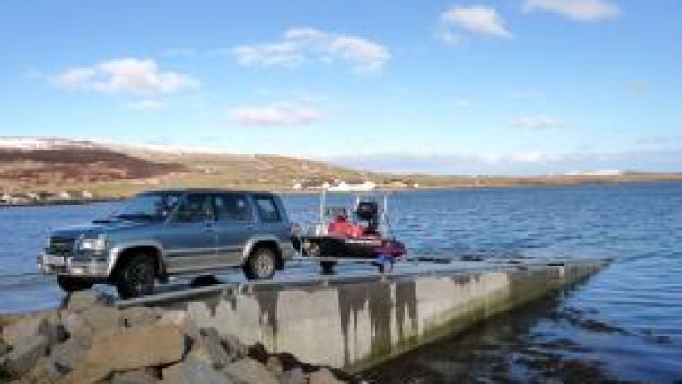
The design criteria were primarily based on recording bathymetry to decimetre, centimetre or better accuracy using a full-coverage method. Both multi-beam and swath-bathymetry systems meet these survey conditions and are routinely deployed where water depths are typically less than 10m and currents up to 6kts. The survey platform chosen was a Zego sports boat (Zego Ltd) as the catamaran hulls provided a stable platform that could be deployed and recovered by one person on official launch slips but also across beaches or down river banks (Figure 1).
It was determined that a survey platform larger than a remote control boat was necessary because of the strong currents often encountered in estuaries and shallow marine settings. The larger platform that would carry an operator also meant that the data being collected could be reviewed in real-time as an almost fully processed solution thus ensuring that full coverage of the survey area was achieved avoiding the possibility of missing areas and having to return after completion of the survey. It also ensured that real-time decisions were more easily made such as avoidance of hazardous conditions and navigating around complex structures. Another criteria met by the small platform was that the sonar system would be in a permanently calibrated mounting to enable the most rapid deployment. This was easily achieved by the Zego boat where the sonar was mounted on a pole located between the two catamaran hulls of the boat (Figure 2).
For initial trials a SEA Swathplus 468kHz (SEA ltd.) sonar system was chosen to give maximum swath coverage in the shallow water while ensuring good quality at far offsets (equivalent to the outer beams of a multi-beam system). Positioning was achieved through a combination of RTK dGPS with a Topcon HiperPro (Topcon Positioning Systems Inc.) where a radio link was maintained with a separately deployed base station for corrections. Heading was supplied by a Hemisphere Vector system (Hemisphere GPS) and motion reference by a TSS DMS205 MRU (Teledyne Techonologies) mounted on the sonar head. Critical to surveying in estuaries is the sound velocity as this can rapidly vary with different salinities during flood/ebb tides and this was monitored using a Valeport MinSVP (Valeport) again mounted on the sonar head. Vertical sound velocity profiles were obtained using a Solinst CTD at hourly intervals throughout the data collection. All units were controlled and data was recorded by an IP65 rated ruggedised Fox-151 (Aaeon Corp.) computer (Figure 3) on which separate navigation software (Hypack) was used to efficiently manage the survey. In addition to the primary sonar, a secondary navigation system with a single beam sonar recorded additional information including a log of water temperature. Because the system is permanently mounted on the vessel, calibration is rapidly achieved using standard patch tests, which together with the RTK dGPS positioning allow for minimal processing to achieve high-quality survey results.
Shallow Estuary Surveys
Two examples are given of half-day surveys using the shallow-water craft. The first example is from the tidal estuary reach of the River Avon, east Dorset, UK from Christchurch southeast to its mouth at Hengistbury Head. The estuary is extensively used for maritime recreation with large numbers of both seasonal and permanent moorings. The estuary is typical of many on the south and east coasts of the UK with large shallow sandbanks and mudflat exposed at low tide. The main navigation channel is narrow and can seasonally be shallow dependent on winter storm and flood conditions. The Avon experiences a turbid flow with low visibility for most of the estuary due to heavy sediment loads. A base station for the RTK dGPS was established at the north end of the survey grid and radio signal maintained with good strength across the survey to the outer estuary 2.5km distant despite local obstructions including buildings and low hills. The craft was deployed on a small fishing launch ramp and the survey of the main channel (Figure 4) completed in 4 hours. Bathymetric data processing was completed in a further 4 hours with analysis of the backscatter data completed in a further 2 hours.
The maximum depth of 5m was recorded at the confluence of the Avon and Stour rivers, with the widest part of the navigational channel at approximately 100m to the south of this, where the average depth is only 2.5m. At this place the necessity of conducting the survey using a wide-swath sonar becomes apparent in order to minimise the number of survey lines to cover the area.
Harbour Surveys
The second survey example is from Anstruther harbour on the east coast of Scotland. This harbour is typical of many small harbours in the UK that provide moorings using pontoons mainly for pleasure craft with a few commercial vessels such as dive charters, fishing and lobster/crab boats. It is also typical in that resources are not readily available to monitor silting of the harbour on a regular basis for maintaining the navigation channels to full commercial standards. Cost-effective solutions of survey are thus desirable. The harbour has an inner part with three pontoons for pleasure craft and an outer part with slipway and a gentle shallow to a sandy beach. The Zego-based bathymetry survey was conducted for the entire harbour and surrounding seawalls over a 2-hour period that included launch and recovery of the vessel. Silting of the inner harbour beneath and around the pontoons was clearly mapped as was the main access channel (Figure 5).
Small Crafts for Rapid Survey
The small craft developed for this research project is a versatile platform that meets many of the needs for very shallow, nearshore and inland water body surveys. The system is easily deployed by one person and is both rapid in data acquisition and turn-around in processing to final product due to the permanent equipment mounts that require minimal calibration. The current system is routinely deployed together with a RTK dGPS and separate base station. With the sonar and RTK dGPS or with post-process dGPS solutions it is possible to achieve sub-10cm accuracy in horizontal and vertical survey; this could be improved with the use of higher specification multi-beam and positioning equipment. It is also possible that similar accuracies in mapping could be achieved with mobile phone-based positioning systems, however, mobile coverage is not always present throughout remote locations in the UK. The vessel is also capable of carrying different scientific payloads and has been tested for water quality survey with instruments to measure temperature, salinity, ph and has also been fitted for conducting shallow, high-resolution sub-bottom sonar surveys with parametric sounders. The Zego thus offers an alternative, cost-effective, adaptive survey platform for many shallow-water situations.
More Information
-
Geen, M. Dobbins, P. and Byham, P. 2010 Qualifying Interferometric Sonar Data. Oceanology International, London, 2010
- Neal., M., Bates, C. R., Blanchard, T. Hubbard, A. and Woodward, J. (2012). In Press. Field Robotics. A hardware proof of concept for a remote control glacier surveying boat
- Pfennigbauer, M. and Steinbacher, F. (2012). Hydromapping – High-Resolution Shallow-water Mapping from an Airborne Platform. Hydro International, v. 16, No. 1

Value staying current with hydrography?
Stay on the map with our expertly curated newsletters.
We provide educational insights, industry updates, and inspiring stories from the world of hydrography to help you learn, grow, and navigate your field with confidence. Don't miss out - subscribe today and ensure you're always informed, educated, and inspired by the latest in hydrographic technology and research.
Choose your newsletter(s)


