Are the Bridge Piers Safe?
Submerged Pier Survey by Side-scan Sonar
Bridges with bridgeheads and supports in water need regular inspection, especially the underwater parts, and even more so if they are exposed to current - as scour needs attention. The unexpected collapse of a bridge in Korea initiated a periodic inspection scheme. This article describes experiences with inspection surveys by side scan sonar of bridge heads and bridge pilings.
There are a huge number of bridges in the world. The more mountains a country has, the more bridges there are; just like in Korea or Japan. In Seoul, Korea, an immense tragedy happened when a bridge over the Han river collapsed in 1994. A section of the upper panel street sheared cleanly from the main structure and fell into the Han river - causing the death of 32 people. The main reason was the breakage of a joint between the panel and a vertical support of the bridge. Maybe the bridge structure was weakened by the repeated vortex induced by the river over a long period. Following this tragedy, major bridges in Korea were strictly investigated again and the underwater parts of supporting constructions also became an important focus of inspections.
The bridge piers are very important to rigidly support the upper panels of bridges. To investigate the underwater portion of the heads and pilings we generally a diver with underwater video recordings or handheld ultrasonic imaging sonar devices. However, this method is not always possible or sometimes very difficult to do due to the high current speed and poor visibility. In such cases we can use a side-scan sonar which is normally deployed by cable from a boat. When towing is not possible, e.g. due to high current speeds, shallow water depths or limited water surface area, we fasten the side-scan towfish to the vessel by jigs or we can use a remotely operated towfish-equipped boat (see figure 3). In this way we can see the whole vertical submerged area of the piers by varying the tilting angle of the acoustic beam of the transducer array.
Preparation for Inspection
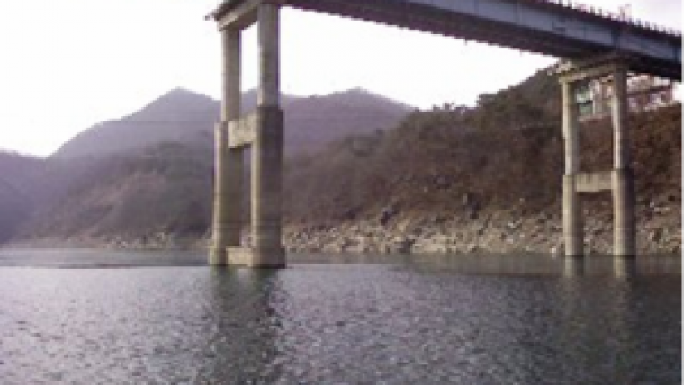
Figure 1 shows the target bridge to be inspected. It has quite tall column piers and was therefore of higher priority than other bridges. For the inspection we designed and assembled a jig frame to firmly fasten the towfish underwater as shown in the Figure 2.
The small wheels were designed to have continuous contact with the pier by the vessel circling around the pier. The towfish can be adjusted for the submerged depth of the body and the tilting angles of the transducer.
Choosing Transducer and Scanning System
We chose the side scan sonar system S-150 using the dual frequencies of 400/1250kHz transducer arrays. Actually we utilised the 1250kHz frequency and the pulse length was 5~25µscovering the maximum range of 35m. The typical images from this towfish are shown in figures 8 through 11.
Methodology of Inspection
In the first trial we used a two-wheel frame as is shown in figure 2 to keep an exactly constant distance between concrete pier structure and vessel during the circling survey. But there were two problems: firstly, it was hard to operate the vessel alongside the surface of the pier, secondly, and more importantly, the images were distorted and unrealistic. So, we decided to survey the submerged parts of the pier by passing several times near the pier in a straight line.
To drive the vessel straight with a fixed distance from the pier, we followed the line plan as is shown in figure 6. Since the rolling motion could sensitively affect the quality of the images, the underwater towfish should neither swing nor vibrate during the survey.
We moved the vessel straight alongside the pier as shown in the figure 7. The vessel speed was kept to 3 knots during the operations.
Results and Discussions
The four directional inspections resulted in the four images surrounding the pier as are shown in figure 5.
This bridge was constructed thirty years ago and we can see the foundations of the piers are partially exposed by the flow of the river. Also, we can find several patches of tiny cracks on the surface of the concrete columns together with some debris.
Another method was also tried using a remotely operated boat which is equipped with a side scan sonar towfish underneath the boat. This sonar boat is shown in figure 3.
The towfish underneath the boat has tilting transducers so that we could easily adjust the depression angle with respect to the depth of the water or total length of the submerged parts of the pier.
This remotely operated sonar boat survey is a good alternative when it rains or it is cold because we could receive the sonar data by wireless transmission in real time. But in windy and wavy weather the sonar image was deteriorated and the attitude sensor showed us poor motions. So, this boat is recommended in relatively calm weather in surveying not only piers but also dam structures and harbor structures in shallow water.
Presently a couple of governmental organisations using this method to survey the twenty-two bridges of the Han river which passes through the capital city Seoul in Korea.
Other Side-scan Sonar System experiences in Korea
There are more than twenty private ocean survey companies as well as the governmental organisations such as KORDI (Korea Ocean Research and Development Institute), NORI (National Oceanographic Research Institute), NGI (National Geographic Information Institute) in Korea. The side-scan sonar system is one of the most frequently used survey equipment. The major applications are monitoring the fish farm structures, measuring the volume of ocean wastes, searching for drowned personnel, mapping the seabed, and used by the Navy for locating mines. Several sample reports are available.

Value staying current with hydrography?
Stay on the map with our expertly curated newsletters.
We provide educational insights, industry updates, and inspiring stories from the world of hydrography to help you learn, grow, and navigate your field with confidence. Don't miss out - subscribe today and ensure you're always informed, educated, and inspired by the latest in hydrographic technology and research.
Choose your newsletter(s)


