Bathymetric data optimizes hydropower generation in Switzerland
Ensuring the safety and protection of Swiss river and reservoir infrastructure
The acquisition of bathymetric and sidescan data is essential for the Swiss energy company Axpo to maintain its hydropower infrastructure, especially as debris that glaciers dump into Switzerland’s rivers and lakes can severely damage machinery. The monitoring and measurement of siltation and scouring help to secure optimal power generation, and Axpo’s dam safety department has used an interferometric bathymetric sonar for these purposes since 2019. In 2022, the team received a new AI upgrade for the sonar, which has already been put to use to make sure that the water keeps flowing.
Today, more than 60% of Switzerland’s electricity is generated by hydropower, and more production capacity is planned to meet growing consumption and negate a potential energy gap. The new capacity will come from major projects and smaller innovations, as well as optimizations and extensions, all of which require accurate bathymetric or sidescan data.
As an example of a smaller innovation, and with an understanding that every kilowatt-hour will count in the future, Axpo installed a small 2.5MW turbine in the water transfer line between the Curnera and Nalps reservoirs. This previously untapped resource came into operation in early 2022 and is expected to produce up to 10 million kilowatt-hours of electricity per year, enough to supply around 2,200 households.
While new capacity is clearly required, maintaining existing capacity is a huge challenge, especially considering the amount of glacier debris that makes its way into the water network, potentially causing severe damage to the machinery at hydropower plants in addition to impacting ecosystems further downstream. Bathymetric and sidescan data are essential to monitor the build-up of these sediments, so that engineers can decide on the best course of action.
Data collection platform
Axpo’s dam safety department is tasked with collecting, distributing, storing, analysing, processing and presenting data that accurately shows how material collects around the water inlets to the company’s hydropower stations. The department monitors and measures siltation with the aim to inform dredging and other engineering works (including major works such as raising the height of water inlets) to maintain an optimal flow of water with as little foreign material as possible.
While protecting the electricity-generating equipment to avoid shutdowns and reduce long-term fatigue is essential, the data collected also helps engineers to fine-tune the systems based on measured water volumes.
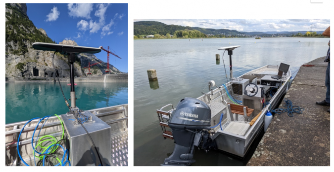
The department’s primary tool for collecting data is a GeoSwath 4 bathymetric sonar provided by UK manufacturer GeoAcoustics, which has so far collected more than 200km of survey lines covering approximately 75km of river and lakebed across the Axpo network. The dam safety team has spent more than a month in operational days using vessels of opportunity as their survey platform. As of September 2022, however, the entire installation including instruments was installed in a single frame of reference on a new boat (Fig. 1).
Measuring siltation and scouring
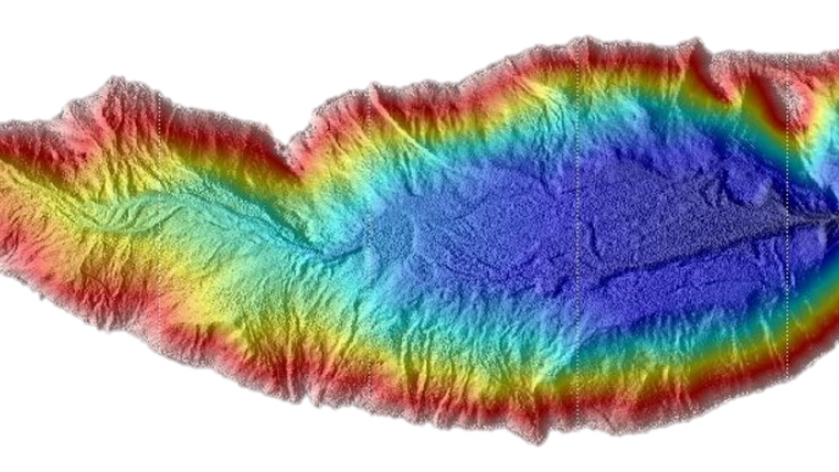
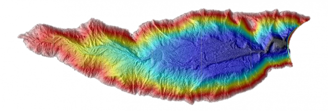
The boat and sonar are now being used to monitor the build-up of silt around important infrastructure such as water inlets and the area of waterway surrounding and including the power generation area, also in the Nalps reservoir. Located 1,908m above sea level and with a dual curve arch dam of 127m and dam crest of 480m, the lake has a water volume of 44.5 million cubic metres. This latest figure was informed by a survey to calculate the siltation levels and the existing reservoir and usable water volumes, which produced the results shown in Figure 2.
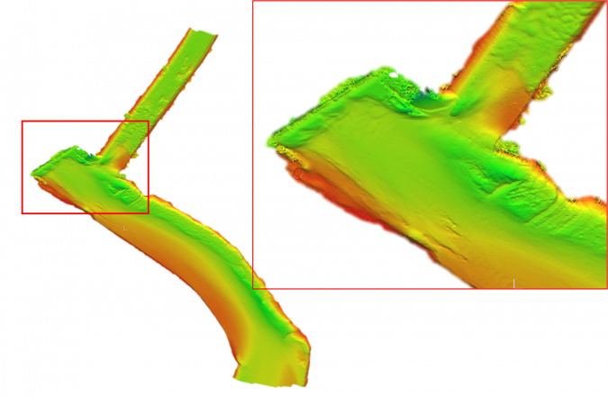
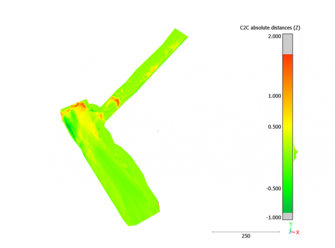
Figure 3.1 shows the results of another survey, where the team using the bathymetric sonar acquired fairly granular data on the level of siltation at a weir on the headwater of a river power plant. This data has proven an effective tool for pre- and post-dredging surveys, here and at many other similar features across the rivers and lakes monitored by the Axpo team. The data is used for both engineering purposes and verification at the end of a dredging project, as shown in Figure 3.2.
While the sonar measures the build-up of silt and debris at the interface between the river or lake and the hydropower generating facility, it is also used by the Axpo team to measure the effects of a phenomenon known as scouring at critical areas across the network. The main aim is to protect the integrity of key infrastructure such as weirs and water inlets from damage caused by the constant movement of water and debris. While scouring is often measured using sidescan sonar, the bathymetric sonar provides the resolution and quality needed for an accurate view of what is happening, allowing Axpo to monitor and protect underwater infrastructure at various sites.
Artificial intelligence
The dam safety department recently evaluated a new AI data processing solution for the bathymetric sonar that automatically detects and eliminate outliers in the data, making real-time data streaming during a survey possible. At this stage, the benefit of this for the Axpo team has primarily been in speeding up processing to the final product as the AI system produces quality-controlled data that provides a significant head start in post-processing. Axpo has also recognized the potential for the AI to improve survey efficiency, as the streamed data can inform the pilot and surveyors of specific features below the boat in real time.
The AI system has been developed through ongoing partnership with AI specialists at the University of East Anglia and GeoAcoustics’ R&D team. Traditional phase-measuring data filtering relies heavily on an expert user setting up filters over the raw data to ‘clean’ it, so the team set out to automate some very specific technical aspects of the data acquisition process. The result is a system that will help Axpo to acquire clean, presentable data much faster.
Considering that new schemes to improve hydropower capacity across Switzerland will demand a continuous flow of updated bathymetric data, any streamlining of survey processes – such as the use of AI in data processing – are welcome. Axpo’s new survey boat will contribute to better efficiency too, as the surveyors can tow it to the river or lake that needs new data or existing data to be verified without having to find an available boat before installing the hydroacoustic package.
The combination of the team’s new boat and AI-upgraded sonar will continue to help support the optimization of existing generating capacity and the build-up of new capacity in the light of the potential energy gap issues during winter and the country’s target to reach net zero carbon emissions by 2050.

Value staying current with hydrography?
Stay on the map with our expertly curated newsletters.
We provide educational insights, industry updates, and inspiring stories from the world of hydrography to help you learn, grow, and navigate your field with confidence. Don't miss out - subscribe today and ensure you're always informed, educated, and inspired by the latest in hydrographic technology and research.
Choose your newsletter(s)


