Bathymetric ENCs in confined waters
The role of hydrographic offices
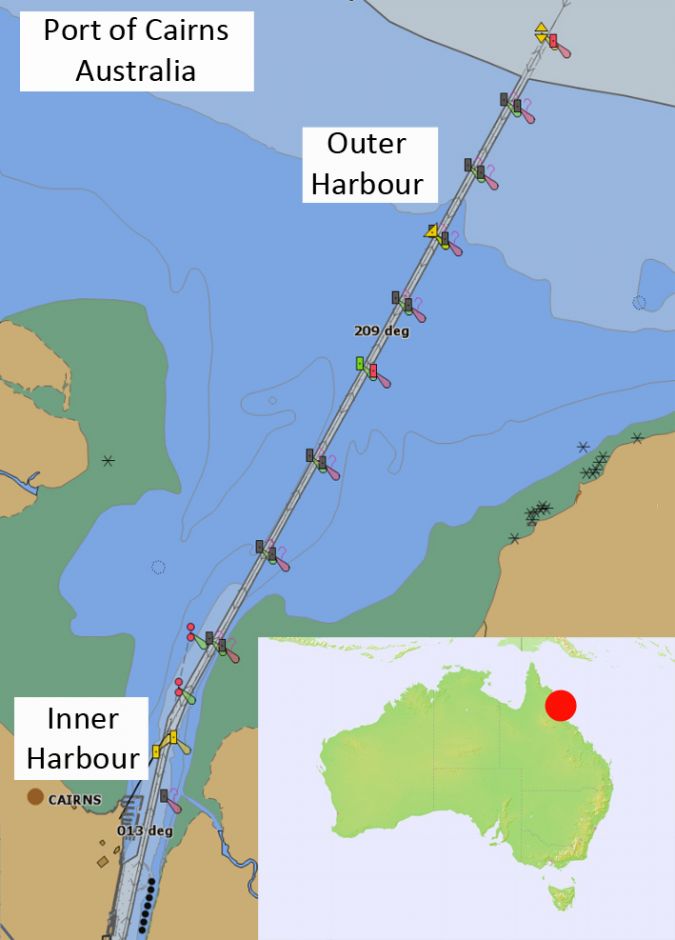
Electronic charts with greater scale and bathymetric content than any hydrographic office’s ENC (equivalent to a paper nautical chart) are not a novelty for many ports around the world. Such charts are normally produced by port authorities and are used by marine pilots on portable pilot units (PPUs). The Australian Hydrographic Office (AHO) has experimented with, and now published, high-density (HD) bathymetric electronic navigation charts (bENCs) for two ports, with more under development. These ENCs – like any other official ones – are available both to ships’ crews using ECDIS and to marine pilots’ PPUs. Why are HD bENCs so important for the conduct of vessels in confined waters? Why is it so important that these ENCs become available to both ECDIS and PPUs? Before answering these two questions, it is necessary to understand the background to the Australian approach.
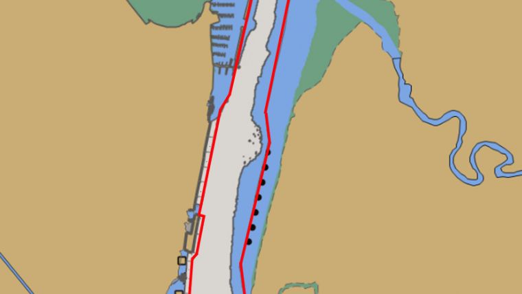
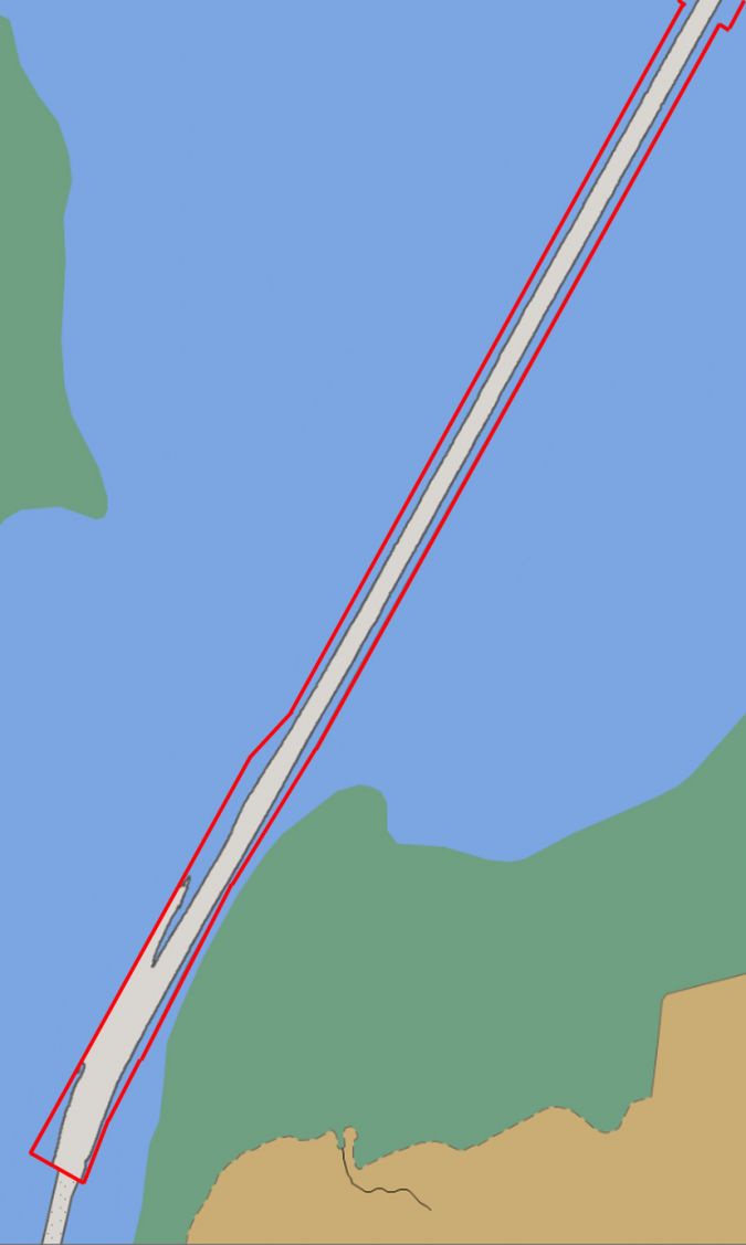
In 2015, a cruise ship operator had to determine the safety margins of its 260m long vessels navigating within the 90m-wide channel that leads to the Port of Cairns (Fig. 1).
A study was carried out at Smartship Australia, a ship simulator specialized in port studies and the training of marine pilots. During the study, ship captains and port pilots used a prototype of a HD bENC. The HD bathymetric content included 1m depth contour intervals and 50m spaced soundings based on survey data provided by the Port Authority.
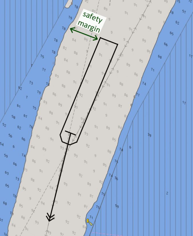
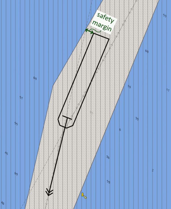
The enhanced bathymetric content revealed significantly increased safety margins. With the same safety depth of 8m, the enhanced detail revealed a much wider navigable channel (Fig. 2) than the one perceived by looking only at the standard harbour ENC (Fig. 3). Understanding of underkeel clearance is also improved. In fact, the standard ENC provides only an 8.3m maintained depth value that is associated with the dredged area that covers most of the outer harbour.
In a previous simulator-based port study carried out in 2010, the lack of enhanced bathymetric content for the same turn between outer and inner harbour became one of the key factors in deciding that the same class of cruise ship could not enter the port with an adequate safety margin. The decision was reconsidered as a result of the 2015 study, and these larger vessels are now able to enter Cairns. This proves the commercial relevance of HD bENCs.
Proof of concept
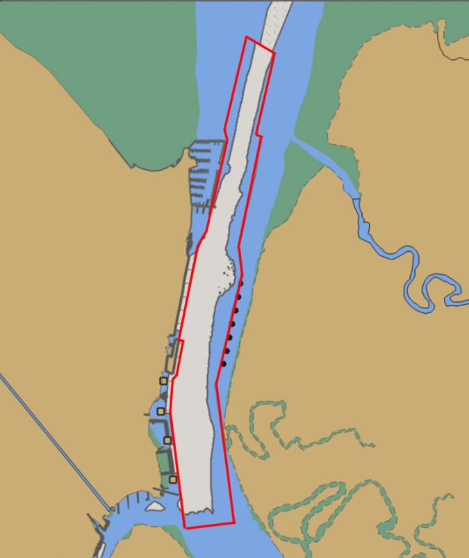
The AHO decided to use the Port of Cairns as proof of concept, and in 2017 two bENCs were published – one for the outer harbour and one for the inner harbour. They were both developed to meet specific Port Authority requirements.
The main features of these bENCs included:
- navigation purpose “6”
- 1:2,500 compilation scale
- coverage based on the availability of HD survey data
- depth contours at 1m intervals, soundings with a 50m spacing, and essential Navaids
Navigation purpose
The AHO idea is to create a new series of navigation purpose “6” bENCs to overlay the exiting series of navigation purpose “5” harbour ENCs. The new bENCs comply with the existing IHO S-57 standard, including not exceeding the existing 5MB data limit. File size is managed by limiting bENC coverage to channels and manoeuvring areas, with the harbour ENC providing remaining coverage in non-critical areas. Long channels are broken into multiple adjacent bENCs, with areas aligned to the port’s survey areas and survey programme. This also allows the AHO to update each ENC simply as new surveys are received. In the case of Cairns, two adjacent bENCs were enough to cover the outer and the inner harbour (Fig. 4 and Fig. 5).
Compilation scale
An ENC compilation scale of 1:2,500 corresponds to a display range (i.e. half ECDIS/PPU screen size) of 250m. For the user, this means the possibility to zoom in without over-scale indication (vertical lines) to a level where a 260-metre-long ship covers about half of the screen size (Fig. 2 and Fig. 3). More in general, the compilation scale of a bENC can be adopted as a compromise between ship sizes and safety margins for the area of interest.
Coverage
The geographic coverage of the two bENCs in Cairns was defined on the availability of suitable survey data provided by the Port Authority. To simplify updating, each bENC is also aligned to the limits of different repeat survey programmes by the Port Authority. In general, the coverage of bENCs should include depths that are as shallow as the minimum draft of the ships calling at a port. This operational requirement needs to be balanced with the capability of the Port Authority to keep the HD bathymetric surveys of the selected area up to date. Surveys must be of a sufficient standard to allow full replacement of the existing bathymetric data for each area, rather than modifying existing data.
Depth contours and soundings
The two Cairns bENCs included depth contours at 1m intervals and spot soundings with a spacing of 50m (Fig. 2). The availability of depth contours at 1m intervals (and their relative depth areas) made it possible to visualize grounding areas (on both ECDIS and PPUs) that were consistent with the 8m safety contour setting on ECDIS. This was based on a ship’s draft of 8m, a tidal height of 2m and the estimated reduction of underkeel clearance due to hull-seabed interactions throughout the channel.
The dredged area covering most of the standard harbour ENC was replaced in the two bENCs by HD depth contours, soundings and depth areas. In 2017, the AHO carried out further consultation with key stakeholders and concluded that levels of detail would be limited to HD bathymetry and any other essential aids to navigation which lies within the coverage of the bENCs.
Finally, the risk of potential clutter on users’ displays (due to the HD bathymetric content) was managed by the AHO by encoding the SCAMIN filtering attribute within the ENCs. This embedded filtering attribute – that allows ECDIS and PPUs users to visualize information gradually as they zoom in – was adjusted on the basis of marine pilots’ feedback during simulation.
Conclusions
So, why are bENCs so important for the conduct of vessels in confined waters?
The first conceptual innovation of HD bENCs is about giving the possibility to visualize safety margins with higher resolution than a standard harbour ENC.
The second conceptual innovation of bENCs is about providing more detailed information on deep soundings within navigable areas, which is an important piece of information to anticipate the effects of hull-seabed interactions. This was not possible by looking only at harbour ENC’s dredged areas that usually cover most of the confined waters with single maintained depth values.
These two concepts bring ENCs to exceed the mere equivalence to paper charts and to take full advantage of high-accuracy electronic navigation systems to monitor real-time ship’s position and heading when safety margins are tight.
Why is it so important that bENCs become available to both ECDIS and PPUs users?
Because the risk of ever decreasing safety margins to conduct vessels in confined waters requires the ship’s crew to be on the same page with the marine pilot, especially when safety margins are small. Sharing mental models is in fact the essence of Bridge Resource Management (BRM), whose ultimate aim is the prevention of accidents caused by intentions and/or actions not challenged in due time or not challenged at all. bENCs support one of BRM’s essential components: the implementation of a ’pilotage plan’ agreed between the ship’s crew and the pilot.
In a recent paper of the IHO ENC Working Group (April 2018), the AHO has identified common pilotage plans as the justification for the production of HD bENCs. This is a remarkable move towards the integration between BRM and electronic navigation in confined waters.
The AHO has succeeded in demonstrating that HD bENCs can be created and maintained in S-57 format. The challenge ahead is managing new stakeholder requirements and re-prioritizing charting activities by rationalizing the existing paper chart portfolio and making as much use of cartographic automation as possible.
In order to manage stakeholder requirements, cartographers need to understand the demands of navigation in confined waters, while users need to understand the potential and constraints of existing IHO standards. In Australia, this mutual understanding was promoted during the numerous simulator-based training courses attended by marine pilots, harbour masters, ship’s crew and AHO cartographers.
Other IHO Member States around the world may benefit from the AHO experience, which demonstrates how HD bENCs can foster both commercial interests and safety of navigation.
Acknowledgements
In Australia, the idea of official electronic charts optimized for navigation in confined waters matured in 2015, but it dates back 15 years. Ravi Nijjer and Robert Ward worked relentlessly for the mutual understanding between key stakeholders, a critical factor for this achievement.

Value staying current with hydrography?
Stay on the map with our expertly curated newsletters.
We provide educational insights, industry updates, and inspiring stories from the world of hydrography to help you learn, grow, and navigate your field with confidence. Don't miss out - subscribe today and ensure you're always informed, educated, and inspired by the latest in hydrographic technology and research.
Choose your newsletter(s)


