Best Practices and Inspiring Bathymetric Lidar Projects
Bathymetric Lidar is a technique that is used to capture geospatial data of coastlines and waterbodies. The method has the potential to facilitate the fast and efficient creation of hydrographic data, and more and more users are turning to it to support many new and different applications. At Hydro International, we have selected a series of articles on this technique that have been published in recent years, ranging from case studies that zoom in on some challenging projects that combine bathymetric Lidar with other survey methodologies, to in-depth articles on the latest trends and developments relating to this hydrographic surveying technology.
The Study of Mapping the Seafloor
This article will immerse you in the deep water of bathymetry. It explains in detail what a bathymetric map is, what it shows, what methods we use to collect the bathymetric data and, last but not least, how to create a good-quality bathymetric map. It also covers the difference between a bathymetric chart and a hydrographic chart and the techniques that our ancestors used in the past to collect and record depths. Read on...
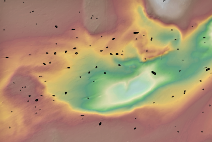
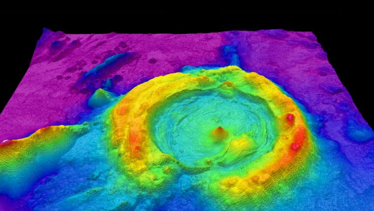
Automatic Shipwreck Detection in Bathymetry Data
Archaeologists have long been interested in shipwrecks. These sites can tell us about ancient transportation and trading routes, technological innovations and cultural exchanges over thousands of years. Documenting shipwrecks can be a difficult task, however. With breakthroughs in remote sensing technology (specifically sonar and radar), researchers have been able to acquire highly resolved maps of ocean floors. Consequently, we can also locate cultural objects – like shipwrecks – sitting on the bottom of oceans, lakes and other bodies of water.
Acoustically Aided INS and Lidar
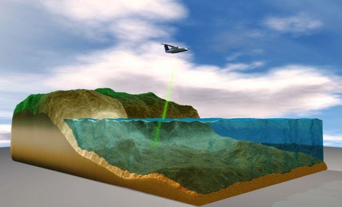
Aerial mobile mapping using Lidar and GNSS-aided inertial navigation has revolutionized the efficiency of land and shallow-water bathymetric surveying. Now, fast ultra-high-resolution subsea mobile mapping is approaching. Millimetre-resolution Lidar sensors have emerged in parallel with major advances in tightly integrated subsea inertial navigation. Wideband Doppler velocity navigation (DVL), long baseline (LBL) observations, simultaneous localization and mapping (SLAM), and automatic calibration and forwards-backwards post-processing join with acoustically aided INS (AAINS) to provide robust dynamic sub-millimetre relative accuracy and centimetric level accuracy over wide areas. Read on...

Pushing Lidar to the Limits
Airborne bathymetric Lidar is an ideal tool to study underwater features in the usually clear waters along the coast of Australia. Due to the remoteness of many of the continent’s coastlines, this is often the only economically viable option for large-scale bathymetric mapping at high resolution. A new toolkit consisting of two airborne Lidar systems flown on a small and slow-flying research motor glider was trialled in NW Western Australia. The same technology will be used over the next three years in the context of a comprehensive study of submerged archaeological landscapes of the ‘Sea Country’, more than 1,000km along the NW Western Australian coast. Read on...
From Concept to Feasibility in Aerial Mapping
Starting in 2005, the French Naval Hydrographic and Oceanographic Office (Service hydrographique et océanographique de la marine [Shom]) and the French National Geographic Institute (Institut National de l’Information Géographique et Forestière [IGN]) began conducting, as part of the national project Litto3D, a series of coastal surveys of metropolitan France and some overseas territories. This article provides insight into the evolution of Shom's expertise in airborne Lidar bathymetry (ALB). Read on...
Technology in Focus: Bathymetric Lidar
With sea-level rise and increases in the severity of extreme natural events, there has been a renewed push to further our understanding of the coastal zone. Fundamental to understanding risk in areas of high vulnerability is capturing the nearshore land and sea surface. Bathymetric Lidar is the most effective and cost-efficient technology to capture both the land and seafloor simultaneously to provide a continuous, detailed 3D elevation model along the coastline. Its ability to successfully capture elevation on both sides of the coastline, over areas stretching more than 100km, has made bathymetric Lidar the ‘gold standard’ for coastal vulnerability and nearshore benthic habitat modelling. Read on...
Multi-sensor Coastal Mapping
Fugro recently tested a multi-sensor approach to balance growing data needs with limited agency budgets. Coastal mapping programmes are quickly becoming a priority for government agencies across the globe. The desire to better define and understand the land/sea interface is based on several interrelated factors, including sea-level rise and its impacts on coastal populations, the growth of and reliance on a blue economy, and the need to maintain critical nearshore habitats in the midst of a changing landscape. Read on...

Value staying current with hydrography?
Stay on the map with our expertly curated newsletters.
We provide educational insights, industry updates, and inspiring stories from the world of hydrography to help you learn, grow, and navigate your field with confidence. Don't miss out - subscribe today and ensure you're always informed, educated, and inspired by the latest in hydrographic technology and research.
Choose your newsletter(s)


