Bibby HydroMap Strengthens Asset Inspection Service Offering
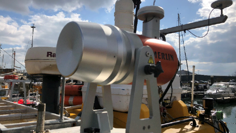
Bibby HydroMap has announced the expansion of its specialised asset inspection survey technology with the purchase of the Carlson Software Merlin Lidar mapping system. The Merlin Lidar system will complement Bibby HydroMap’s existing marine and terrestrial survey equipment to deliver improved high-resolution datasets of objects of interest, with the aim of enhancing the validity of asset inspection services.
The new system is a vessel-based 3D mobile marine laser scanner system, designed to seamlessly integrate with existing hydrographic equipment, therefore allowing simultaneous data acquisition above and below the waterline. Producing an accurate 360° dataset in a single pass, both acquisition and data processing timescales are reduced compared to conventional inspection techniques.
With flexible deployment options, and applications in a range of environments, the versatility of the Merlin Lidar system offers optimum performance and gives Bibby HydroMap access to the latest laser surveying technology, improving the terrestrial component of their asset inspection point cloud data.
Above-surface solution
Bibby HydroMap’s inshore vessel Eagle is currently fitted with the new system and can be rapidly mobilised with all other asset inspection equipment to reduce deployment timescales. The system has been successfully used on recent asset inspection projects throughout the UK.
“The Merlin Lidar system is the specialist’s tool for marine based Lidar data acquisition. Its simple, robust, marinised design affords quick, repeatable mobilisations along with the confidence that the equipment can handle the environmental conditions expected from European coastlines”, said Nick Bowley, Senior Surveyor at Bibby HydroMap. “Coupled with its use of industry leading sensor components and its compatibility with standard hydrographic acquisition packages, the Merlin Lidar allows Bibby HydroMap to offer a high-quality turnkey ‘above-surface’ solution to our clients, and complements our existing offerings of traditional bathymetric, geophysical, geotechnical and sub-surface scanning products”, he added.

Value staying current with hydrography?
Stay on the map with our expertly curated newsletters.
We provide educational insights, industry updates, and inspiring stories from the world of hydrography to help you learn, grow, and navigate your field with confidence. Don't miss out - subscribe today and ensure you're always informed, educated, and inspired by the latest in hydrographic technology and research.
Choose your newsletter(s)


