Crowdsourcing for Frontier Waters?
Rather Desire Lines and Snow Storms
I’ve read with some interest articles recently published in Hydro International and other geomatics periodicals on the concept of crowdsourcing to capture data. This topic deserves to be discussed in more detail, particularly as it applies to charting frontier or unsurveyed waters. I trust crowdsourcing has its place; however, it is not to be interpreted as a one-size-fits-all approach to data capture and as a substitute for real hydrographic services and SOLAS Chapter Five obligations. As this is an ‘Insider’s View’ I hope it is understood that the ‘View’ expressed here is mine and should not to be interpreted as that of my HO.
The concept of free or nearly free, public domain data appears to be catching on and has spurred commercial interests around the provision of data validation and publication services to enable the mariner-at-large to capture and disseminate hydrographic information. The resulting marketed imagery is impressive and the service has been coined as a “Poor Man’s Multi-beam”. But, then again, I’ve seen what photo editing software can do for data holidays!
While there appears to be a good business case for free data in mature southern waters where there’s a viable level of vessel traffic crisscrossing coastal waterways, the level of traffic chaos which serves to buoy the data capture concept of crowdsourcing ends in frontier waters. This is, however, with but one small exception; ecotourism and particularly those tour companies whose bread and butter are all about sending chartered vessels off the beaten path. The key word here is beaten path and here I draw attention to my reference to desire lines and snow storms.
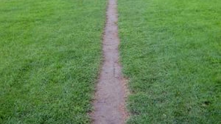
In The Poetics of Space, Gaston Bachelard states, “Desire lines can usually be found as shortcuts where constructed pathways take a circuitous route”. They may also be informal pathways created in the absence of any constructed pathways. The desire line is created by repetitive use; travellers beating down a route which becomes the most desirable and recognisable pathway.
Desire line. (Photo credit: Sonatype Blog)
Try to picture a four lane highway during a winter storm. If left unplowed, those four lanes typically close down to but one beaten path formed from tire ruts free of snow (and hopefully ice) by traffic concentrated to its course. This scenario is similar to ice escort where the lead vessel breaking the ice will keep the safest route and her consorts will follow. In frontier waters, where ’constructed pathways’ (surveyed shipping corridors) are few and far between, the bathymetric backbone of a chart is that of a single charted track line of soundings. This is a nautical desire line. Such a track will be followed by the prudent mariner without deviation except in cases of emergency or negligence where the former will typically be the follow-up action resulting from the latter.
Here is the case for systematic survey, otherwise it’s full stop.

Value staying current with hydrography?
Stay on the map with our expertly curated newsletters.
We provide educational insights, industry updates, and inspiring stories from the world of hydrography to help you learn, grow, and navigate your field with confidence. Don't miss out - subscribe today and ensure you're always informed, educated, and inspired by the latest in hydrographic technology and research.
Choose your newsletter(s)


