Enhanced solutions for seagrass monitoring
Advanced underwater surveying combined with deep learning
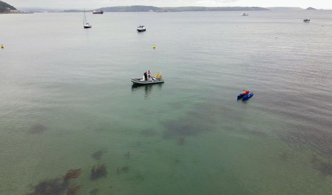
A new, non-invasive method to measure and monitor seagrass biomass on the seabed around England’s south-west coast has been successfully demonstrated this year as part of a collaborative project supported by Innovate UK’s Smart Grants programme. The approach made use of an altimeter installed on a USV that was specifically developed for this purpose, and the hydrospatial data was processed and visualized through an advanced cloud-based solution.
The innovative new technique builds on the concept of the acoustic reflectivity of seagrass providing valuable information to characterize submerged aquatic vegetation. It was trialled during two phases in May and September 2022 by the south-west England-based companies HydroSurv and Valeport, working with the University of Plymouth and Natural England.
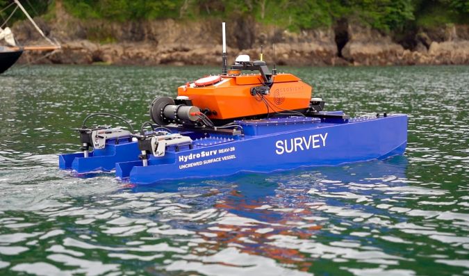
The full-stack solution comprised a Valeport VA500 altimeter installed on a HydroSurv REAV-28 uncrewed surface vessel (USV) specifically developed for the project. A large, validated signal library and deep learning algorithm, developed by the University of Plymouth, deciphered the survey data to predict seagrass distribution. The data was visualized and interpreted in a cloud application created by HydroSurv.
Accurate, cost-effective repeatable surveys
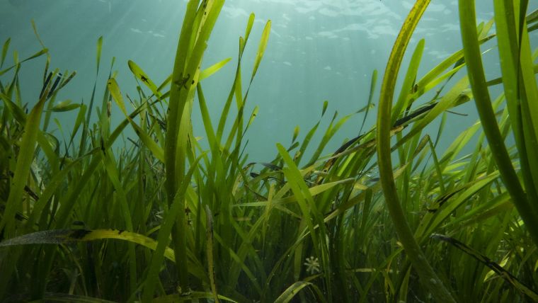
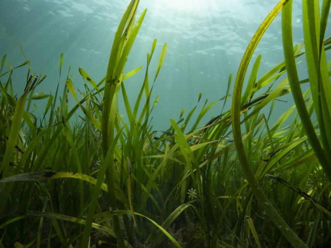
Seagrass meadows are a crucial part of the marine ecosystem and are increasingly recognized for their essential carbon capture abilities. As well as being as effective at storing carbon as woodland, seagrass also provides a vital habitat for young fish, seahorses and jellyfish. It additionally cleans surrounding seawater and helps to stabilize the seabed, thereby reducing coastal erosion.
A USV provides a non-invasive, cost-effective platform to facilitate accurate repeat surveys that can be compared to monitor temporal changes in seagrass coverage for the planning of protection and regeneration projects at biodiversity-rich worksites. The solution is set to change the way in which seagrass meadows are monitored in the future, complementing traditional diver surveys to cover much larger areas and enable rapid resurvey work as required.
The work carried out in the collaborative project directly translates into impact, addressing UN Sustainable Development Goal 14 ‘Life below water’. Rapid data acquisition, processing and visualization of seagrass meadow density is critical for coastal practitioners in developing their current understanding of seagrass meadows as vital ecosystems. New technologies, such as USVs equipped with innovative sensors and instrumentation, are enabling cost-effective and repeatable surveys that support effective conservation and restoration projects.
Customized tools for deeper analysis
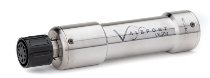
Valeport’s VA500 altimeter, which uses state-of-the-art signal processing, was customized specifically for this project. It is an underwater positioning instrument that is primarily fitted to autonomous, remotely operated or towed vehicles, both surface and underwater, to give an accurate measurement of height above the seabed. The VA500 uses advanced digital signal processing to hone-in and track the seabed, ignoring spurious echoes. It works by emitting an acoustic pulse (500kHz) and times how long it takes for echoes from distant surfaces to return; given the speed of sound in water, the sensor can then calculate a distance from the measured time.
For this project, the sensor was simplified. A standard VA500 receives multiple signal echoes and must decide which one represents the seabed. The customized version of the altimeter used on HydroSurv’s USV didn’t have to make that decision. Instead, it output all measured echoes, together with an indication of how strong and how sharp each signal is, for the University of Plymouth to analyse with their software. The project partners worked together to develop custom firmware that delivers low noise, high-quality, correlated acoustic profiles at up to 10Hz, enabling deeper analysis, exploration, mapping and classification of the acoustic information gathered.
The customization presented one main challenge, namely ensuring that the sensor was able to output much larger quantities of data than usual while maintaining a sensible sampling rate. The absolute accuracy of data from any altimeter generally depends on knowledge of the sound speed in the local environment. However, more important for this application was the resolution of the data and its ability to distinguish multiple echoes from objects that were close to each other.
This was the first time that Valeport had customized the performance of the altimeter for a client, although other mechanical adaptations to fit specific vehicle requirements have been made in the past. The company hopes to realize more opportunities for this version and is also considering other applications that could be addressed with further changes and optimizations.
Improved efficiencies with deep learning algorithms
The application of deep learning algorithms for the acoustic detection and characterization of seagrass beds has introduced improved accuracy and efficiency over more traditional techniques. Combined with the advantages of lightweight autonomous survey platforms, it introduces a step change in accurate and repeatable seagrass mapping.
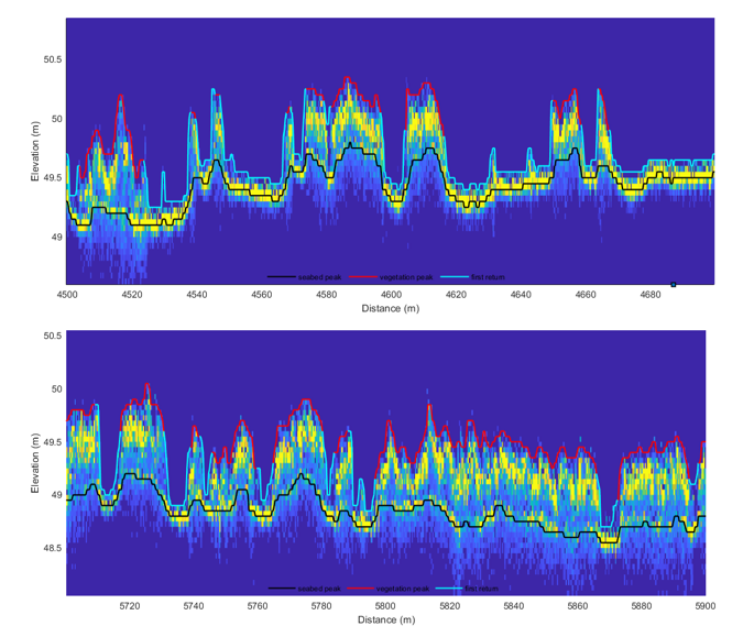
The algorithm developed for this project, named SeagrassNet, uses a machine learning algorithm (recurrent neural network, or RNN) to detect the presence or absence of seagrass in echosounder data. The developed algorithm ingests raw echosounder data from the Valeport VA500 and uses the RNN to classify whether seagrass is present or absent and where within each echosounder ping the most likely location (elevation) of the seabed and seagrass canopy is, enabling the height and density of any seagrass present to be detected. When tested against a large database of labelled echosounder data, SeagrassNet successfully labelled 95% of the validation data points.
The benefits of using a machine learning algorithm for detecting and measuring seagrass, rather than a more traditional rules-based approach, is that the algorithm is trained to differentiate the seabed and seagrass from any other subaqueous features, therefore requiring less manual effort during quality control than traditional seagrass detection methods. With enough labelled echosounder data, the algorithm could also be trained to label other subaqueous features such as frond weed, kelp and bladderwrack.
Uncrewed vessel developed to project specifics
To develop the REAV-28 USV hull form for this project, HydroSurv subjected over 42 candidate hull designs to motion analysis using simulation in line with the sea conditions expected at the UK worksites. Mass and drag properties were optimized relative to overall hull length and the resulting design performed well in a range of sea conditions throughout trials.
The aluminium USV is propelled by two Torqeedo 1,100W outboard motors, powered from four 915Wh propulsion batteries located inside the hulls, while general service power is provided from a separate 1,280Wh battery inside the cross-deck compartment. The vessel can operate at service speeds up to 5 knots, with good line-keeping performance and cornering at all speeds. The USV also incorporates a cast winch system that is fully integrated into the vessel control systems. As a fully electric, non-invasive survey platform, it is readily portable to inland and coastal worksites and can be rapidly deployed, operated and recovered with a small survey team.
The UK has lost around half of its seagrass since the mid-1930s, due to factors ranging from seagrass wasting disease (SWD) and pollution to physical disturbance from the anchoring, launching and mooring of leisure boats. The £2.5 million LIFE Recreation ReMEDIES partnership ‘Save Our Seabed’ is a five-year marine conservation project that was launched in July 2019 to protect and restore these sensitive habitats. Valeport sponsors the initiative, which is funded by the EU LIFE programme and led by Natural England in partnership with the Marine Conservation Society, the Ocean Conservation Trust, Plymouth City Council/the Tamar Estuaries Consultative Forum and the Royal Yachting Association.
Acknowledgements
Sonardyne International for loan of a Mini Ranger 2 acoustic positioning system with Nano beacons for the accurate positioning of diver observations during field trials (as part of their long-standing partnership with the University of Plymouth).
GEOSIGHT Limited for loan of their REAV-28 USV, a 2.8m catamaran hulled vessel with fully electric propulsion built by HydroSurv, suitable for deployment and recovery from foreshores and beaches for a range of hydrographic and environmental survey applications.

Value staying current with hydrography?
Stay on the map with our expertly curated newsletters.
We provide educational insights, industry updates, and inspiring stories from the world of hydrography to help you learn, grow, and navigate your field with confidence. Don't miss out - subscribe today and ensure you're always informed, educated, and inspired by the latest in hydrographic technology and research.
Choose your newsletter(s)


