Fugro Takes On Barents Sea Metocean and Ice Network Project
Fugro has begun a three-year period of metocean and ice data acquisition as part of the Barents Sea Metocean and Ice Network Project. The data will help operators to better understand relevant operational uncertainties and risk factors in the region known as ‘The Far North’.
The Barents Sea represents a frontier region for oil and gas exploration. The Norwegian Petroleum Safety Authority has recognised this and in its guidance states that appropriate measures to mitigate risk should be undertaken.
Statoil is leading a Joint Industry Project (JIP) to gather additional and necessary metocean and ice data in the region. Early acquisition of data in frontier regions is key to reducing risk for operators which, in turn, offers potential cost savings, for example through appropriate selection of drilling assets for the metocean regime, and optimisation of the timing of drilling campaigns. There are also numerous advantages to the JIP participants related to data sharing across a frontier region, such as increased understanding of metocean processes and their spatial extent and an extended data pool against which to validate models.
Having successfully worked with Statoil and several of the other JIP participants on a number of complex metocean measurement projects throughout Norwegian waters, Fugro was contracted for the project.
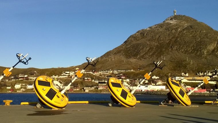
Buoys for Data Collection
In October 2015 five Fugro-manufactured Wavescan buoys, one current- and water level-monitoring mooring, and five ice thickness and current-profiler moorings were deployed at offshore sites between Hammerfest and Svalbard. The robust Wavescan buoys, which are ideally suited for the conditions of the Barents Sea, are now collecting raw wave, current, meteorological and sea-water parameter data, processing the information and transmitting the summary data via satellite link. Real-time data are then displayed on a project-specific webpage that can be accessed by the client via secure log-in. Data from the current- and water level-monitoring mooring, and the five ice measuring rigs are being stored within the instruments’ internal memories for download at service visits, which are scheduled at six-month intervals for the buoys and annually in the open water season for the ice measuring equipment.
Safe Operations
Fugro’s Mark Jones reports that additional collection of data related to the metocean and ice regime will further strengthen the safe planning of operations, design engineering, calibration of models and validation of weather forecasting in this frontier region. Fugro’s planning and management of site visits ensures that data acquisition is maximised. Equipment needs to be deployed and serviced during open water periods, and to collect data during the ice seasons.
The first service visit was undertaken in March/April 2016, following which Fugro processed, analysed and reported data collected over the first phase of measurements. The final dataset will be produced for the JIP partners upon completion of the measurement campaign in autumn 2018.

Value staying current with hydrography?
Stay on the map with our expertly curated newsletters.
We provide educational insights, industry updates, and inspiring stories from the world of hydrography to help you learn, grow, and navigate your field with confidence. Don't miss out - subscribe today and ensure you're always informed, educated, and inspired by the latest in hydrographic technology and research.
Choose your newsletter(s)


