Grounding of the Queen Elizabeth 2 (response)
The Rest of the Story
Last month we brought you the story of the famous Cunard cruise liner Queen Elizabeth 2 (QE2), which grounded on 7 August 1992 off the coast of Martha’s Vineyard and the state of Rhode Island. Captain Lusk stated that the US judicial system arrived at the wrong decision regarding who was at fault for the QE2 grounding and suggested that the US agency for this survey, the US Coast and Geodetic Survey, predecessor to the National Oceanic and Atmospheric Administration (NOAA), should have investigated and determined the shoal depth. On this page we give NOAA the opportunity to respond to this.
View Larger Map
Last month we brought you the story of the famous Cunard cruise liner Queen Elizabeth 2(QE2), which grounded on 7 August 1992 off the coast of Martha’s Vineyard and the state of Rhode Island. Captain Lusk stated that the US judicial system arrived at the wrong decision regarding who was at fault for the QE2 grounding and suggested that the US agency for this survey, the US Coast and Geodetic Survey, predecessor to the National Oceanic and Atmospheric Administration (NOAA), should have investigated and determined the shoal depth. On the next few pages we give NOAA the opportunity to respond to this.
Grounding incidentsinvolving nautical charts are ex-tremely rare. However, when they do occur, the legal issue usually boils down to whether the hydrographic office was negligent by not con-ducting surveys or applying information to the chart in con-formance with their stated standards. The counter argument involves whether the mariner’s actions were the principal cause of the grounding. In the case of the QE2 grounding, there are arguments to be made on both sides. In my opinion, captain Lusk offers a one-dimensional narrative of the QE2 grounding that is grossly incomplete. Mariners and hydrographers need to understand ‘the rest of the story’ before arriving at their own conclusion about the grounding of the QE2.
What Happened?
It was the final evening of a five-day pleasure cruise for the 1,824 pas-sengers aboard the UK passenger vessel QE2. Suddenly, the 963-foot ocean liner shook with unexpected vibration. Officers and crew on the bridge recalled two separate periods of shaking and rumblings. The mas-ter recollected that the bridge equipment rattled and shook as if it were in heavy seas. Many of the pas-sengers felt a change in the ship’s motion – some thought that a severe impact had occurred. Unfortunately, there was significant damage to the bottom of the QE2. Four of the 36 double-bottom tanks that had been empty were now filled with water and open to the sea. The US Coast Guard was notified and the ship was ordered to anchor in Rhode Island Sound, some 20 miles southeast of Newport, Rhode Island.
Anchorage to Grounding
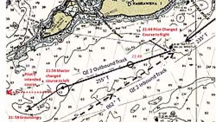
At 21:24, after weighing anchor and manoeuvring to the west and then to the south rounding the northern shore of Martha’s Vineyard, the QE2 increased speed to approximately 25 knots. Figure 1 shows the approximate outbound track of the QE2. The ship was generally following its inbound reciprocal course, heading approximately west-south-west (235° True). At 21:44, about two-thirds of the way out of Vineyard Sound, the QE2 passed the ‘NA’ buoy to star-board. With the buoy abeam, the pilot altered course to the right about 15° and was now steering a course of 250°. The pilot later testified that he intended to maintain that course until he was approximately 2 miles south of the south-western end of Cuttyhunk Island, and then steer 270° to where he would disembark. The pilot had not told the master or the watch officer of his course change, nor of his intent to alter course to 270° when the south-western point of Cuttyhunk Island was bearing north. Figure 2 illustrates the misunderstanding between the pilot and the captain regarding the outbound course.
The QE2’s second officer plotted the new course on the ship’s nautical chart and saw that the new track-line did not coincide with the original course as laid out by the ship’s navigator. The second officer noted that the projected ship’s track-line crossed over a 34-foot rocky shoal area approximately 7.5 miles down range in Rhode Island Sound north of the shoal called Brown’s Ledge. At a speed of nearly 25 knots, the QE2 would pass over the shoal area in about 18 minutes. Not knowing that the pilot intended to alter coursebefore reaching the shoal, the second officer immediately notified the first officer, who in turn informed the master. After being made aware of the discrepancy between the original track-line and the current track-line, the master ordered the first officer to inform the pilot that he would rather pass further to the south – back toward the original track-line. At about 21:54, the pilot complied with the master’s request and turned the ship left about 10°, to a more southerly course of 240°. Four minutes later at 21:58, the QE2 shook violently with vibration. Once the QE2 master and bridge officers determined that the ship had run aground, they examined the nautical chart and calculated the position of the accident. The ship had run aground near a charted depth of 39 feet. A bottom characteristic symbol labelled ‘rky’, indicating a rocky bottom, was in close proximity to the charted 39-foot depth.
Mysterious Squat
How could the ship run aground in an area that was 39 feet deep? The QE2 ’s draft was only 32´4". In addition, an extra 1.5 feet of tide over the chart’s water level datum should have provided a water depth of 40.5 feet – an under-keel clearance of over 8 feet. The maths did not add up, so National Transportation Safety Board (NTSB) investigators had to unravel the mystery. Most mariners are aware that when a vessel moves through shallow water, it experiences a complex hydrodynamic phenomenon known as squat (see text box). The QE2 master and the state pilot were generally aware of the squat phenomenon experienced by vessels in shallow water. Both testified that they thought the squat of the QE2 was 1.5 to 2 feet while leaving Vineyard Sound. However, there seemed to be no sound empirical or theoretical basis for their estimates. The NTSB commissioned a study by the US Navy’s David Taylor Research Center to compute theoretical values forQE2squat, under similar speed and water depth conditions. The study concluded that the QE2 could have experienced up to 8 feet of squat under the conditions of the grounding.
Chart Accuracy
Even with today’s full bottom-coverage sonars, can hydrographers guarantee that their surveys represent the bottom with absolute accuracy? Should mariners have unconditional confidence in the information conveyed on any nautical chart? Most mariners understand that nautical charts may not be 100% accurate – thus the term ‘prudent mariner’ comes into play. Generally, the deficiencies that mariners become aware of are the ones they can see, for example, a buoy being off station or a landmark that has been removed. It is rare that a mariner will find a depth discrepancy by grounding. There is a simple explanation for this: a prudent mariner will factor in a safety margin when using nautical charts. Prudent mariners have the wisdom to know that charted depths might not be 100% representative of the true bottom.
After evaluating all of the survey and cartographic information in hindsight, captain Lusk concludes that fault lies with the hydrographers of the Coast and Geodetic Survey vessel Lydonia and the subsequent handling of the re-survey requirements by NOAA and its predecessors. However, before rendering judgment on the hydrographers of the Lydonia or the US Hydrographic Office, one must understand the context of the 1939 survey (see text box).
Research Survey
As commanding officer of the NOAA ship Rude in 1992, I was directed to survey the site of the QE2 grounding. It is important to note that theQE2had a static draft of 32´4" at the time of the grounding. During the initial survey, the Rude found the same bottom complexity described in the text box. Using a narrow-beam echosounder, the ship ran line after line at 10-metre spacing over the rocky bottoms. It took three days to ensonify a small area so that divers could finally identify the exact rocks where the QE2 grounded. The field least depths were in the neighbourhood of 33 and 34 feet. Interestingly, the survey depth at the charted 39-foot depth was precisely 39 feet – so the charted depth was accurate. The 33-foot depths discovered within 200 metres of the charted 39-foot depth showed that the true bottom was not fully represented on the chart. A 31-foot depth not involved in the grounding was also discovered in the general vicinity. Figure 3 illustrates the 1992 survey depths discovered in the area after the grounding. Figure 4 shows the side-scan sonar image of one of the rocks that the QE2 impacted.
When I examine the 1939 survey, I admit that as a hydrographic surveyor in 1992 I like to think that I would have further developed the 39-foot sounding. However, I hesitate to second-guess the hydrographers of theLydonia, given the relatively primitive tools they had to work with at the time. In fact, having surveyed in those boulder fields for over four years of my career, I was often amazed at how these 1939 hydrographers discovered some of the isolated boulders that were accurately charted. On the other hand, there were dozens of instances where theRude, with its side-scan sonar capabilities, found uncharted features not discovered by prior surveys.
Who was at Fault?
Who or what was to blame for the QE2 grounding? Was it the master, the pilot or both for not communicating properly? Was it the mysterious squat phenomenon? Or was NOAA’s inaccurate nautical chart to blame? The grounding may have been one of the unluckiest events in the history of navigation. If the ship had followed the pilot’s intended track, it probably would have passed safely north of the rocky grounding site. If the QE2 followed its inbound track, as the master presumed it would, the ship would have passed safely south of the grounding site. The master’s apprehension with the track being followed by the pilot and its projected intersection of a down-track shoal prompted him to recommend a course change to the south. If this course change had been executed a minute or two earlier or later, the grounding would probably have never occurred.
Independent of the later court case, the US NTSB examined the accident and made the following conclusions. (1) The grounding would not have occurred if a master/pilot conference had been held, which would have made the master aware of the pilot’s intentions, and if an agreement on an appropriate route to the pilot’s disembarkation point had been reached. (2) If the master and pilot had discussed and determined the location of a new track-line before the pilot altered course to pass south of Brown’s Ledge, they would have been alerted to the track-line’s proximity to the 39-foot area and probably avoided the shoal. (3) The speed of 25 knots selected by the master and agreed to by the pilot left inadequate room for a margin of error. (4) The use of effective bridge resource management techniques by officers in charge of navigation watches increases the safety of navigation. (5) Adequate squat information was not available to the crew. The NTSB findings highlighted the master/pilot miscommunication and the fact that there was never an intention for theQE2to pass over the 39-foot charted depth. Therefore, even though depths of 32 feet were found in the area by modern surveys, the NTSB largely exonerated NOAA’s charting programme.
Epilogue
NOAA is one of the few government charting organisations in the world that can be sued for information presented on its nautical charts. The owners of the QE2 sued the USA in the US District Court in New York in 1994 (Cunard Lines Limited vs USA), alleging that the incident was caused by negligence on the part of NOAA and/or its predecessors, in con-ducting improper hydrographic surveys of the area. Specifically, it was alleged that NOAA’s last survey of the area (performed in 1939) was negligent because the 39-foot sounding had not been developed further, which, it was alleged, would have uncovered the shoal soundings nearby. NOAA countered that it had discretion as to which soundings it would develop, and there was no reason to develop the 39-foot sounding further because it was outside the normal shipping lanes, and in 1939, large vessels such as the QE2 never travelled these waters. The case went to trial in 1997 and the judge ruled in favour of the USA, dismissing the complaint.
Court Decision
Several factors worked against a favourable outcome for the QE2. First, the ship almost ran aground elsewhere on its outbound transit. The ship’s echosounding records (Figure 5) demonstrate that it nearly grounded 6 miles north-east of the 39-foot charted depth. While abeam the ‘NA’ buoy, the ship navigated over charted depths of 36 and 40 feet, passing dangerously close to the irregular bottom. Of course, deep draft ships pass within a few feet of the bottom routinely when transiting through dredged channels. However, there are two major differences with the QE2 situation. First, the QE2 was the deepest draft vessel to transit the waters of Vineyard Sound. It may be acceptable to travel within a few feet of the bottom in a dredged channel where vessels of similar draft routinely make the same transit, but when navigating the deepest draft ship to transit an area over a notorious rocky bottom it would seem that a higher degree of caution might be in order. Second, the QE2 had no quantitative information on its squat. Therefore, intentionally travelling over charted depths of 36–40 feet near the ‘NA’ buoy at 25 knots was arguably reckless.
Additionally, when laying out the track-line, the QE2 navigator shaded in the 39-foot depth as an area to be avoided. The pilot–master misunderstanding was the only reason the ship tracked over that area. There is no evidence that the master or pilot thought it acceptable before the accident to travel over the 39-foot charted depth. It was only after the grounding that all parties focused on the charting questions, which conveniently diverted attention from the bridge communication issue.
Finally, the QE2 could have avoided the entire area by following a near-parallel outbound track-line only 0.5 miles to the east, where the ship would have been in 60–90 feet of water – clearly out of harm’s way – for most of its passage through Vineyard Sound. The QE2 followed this deep-water track on its inbound voyage.
After reviewing all the facts, the US Coast Guard, NTSB, and New York State District Court all arrived at a different conclusion to that of Captain Lusk – the primary cause for the grounding was the miscommunication between the pilot and master.
Acknowledgements
This Hydro international response article was originally written for LIGHTHOUSE and is scheduled to appear in ed. 74. Thanks are due to the Canadian Hydrographic Association for sharing this article.
Nick Perugini, Captain , NOAA (ret.) (USA)
Squat
Squat is the combination of (a) sinkage of the hull and (b) a change in elevation of the bow with respect to the stern, known as trim. As a vessel’s speed increases, the water level around the hull is lowered; consequently, the vessel sinks deeper with the lowered water level, reducing its under-keel clearance. The vessel’s draft remains the same; however, the water level surrounding the ship is lowered. The combination of sinkage and trim considerably increases the risk of a ship touching the bottom of a shallow waterway, particularly when a ship moves at high speeds. Squat is a complex phenomenon, unique to a vessel’s hull form. It is difficult to predict by using simple mathematical formulas.
The 1939 Survey
The Coast and Geodetic Survey vesselLydoniaused a Dorsey non-recording echosounder to conduct surveys in the area. Operation of this device involved an operator who monitored a flashing light on a circular meter. The operator recorded the instantaneous depth in a sounding volume at regular time intervals. There was no analogue (paper) record that showed a continuous bottom profile as produced in later-day echosounders. Horizontal positioning was accomplished using three-point sextant fixes. The survey area was covered with basic 400-metre line spacing, and an isolated 39-foot sounding was recorded. Using the discretion it had from theHydrographic Manualat the time,Lydonia’shydrographers performed no further investigation on the 39-foot sounding. Office cartographic reports that evaluated the survey noted the need for further development on this feature; however, the Coast and Geodetic Survey and subsequently NOAA never assigned this follow-up work. As captain Lusk noted, surveys were subsequently conducted in the general vicinity of the 39-foot sounding, but the feature was never revisited after the 1939 survey.
The area encompassing Rhode Island Sound, Vineyard Sound and Buzzards Bay is one of the most geologically complex areas in the coastal waters of the USA. The bottom is composed of glacial till – a mixture of rocks, boulders, pebbles, sand and clay. There are vast stretches of flat bottom that are littered with boulders that rise 20 feet or more off the bottom. These boulders, called ‘erratics’, were deposited by receding glaciers. Similarly, there are larger piles of rocks and boulders that rise in an irregular fashion off the bottom. These are not classic ridge formations that have a wide regular foundation and build to an easily identifiable least depth. They are jagged, individual rocks and boulders that exhibit no regularity. There are boulders that may rise 20 feet off the bottom, and have only a 20-foot wide base. If one surveyed an area with water depths of 40 feet with a narrow-beam echosounder, it would be easy to miss this type of feature, even with 10-metre line spacing.

Value staying current with hydrography?
Stay on the map with our expertly curated newsletters.
We provide educational insights, industry updates, and inspiring stories from the world of hydrography to help you learn, grow, and navigate your field with confidence. Don't miss out - subscribe today and ensure you're always informed, educated, and inspired by the latest in hydrographic technology and research.
Choose your newsletter(s)


