Help, My ECDIS Has Double Vision!
The Use of Time-related Objects in ENCs
Although the use of ECDIS systems is growing rapidly, there are still issues to overcome. For example, those relating to operating anomalies, maintenance of ECDIS software and training. This article describes a misunderstanding among ECDIS users about how some time-related objects were encoded in Electronic Navigational Charts (ENC). What was the cause of this misunderstanding, and what can be done to prevent this from happening again?
To improve the safety of navigation in the area off the coast of the Netherlands between Texel and North Hinder, extensive new and amended routeing measures were implemented at 0000 UTC 1 August 2013. It was one of the most extensive operations involving route changes in the world to date.
Particularly in cases like this with extensive changes, the Hydrographic Office has to manage the production and distribution of nautical charts carefully, reflecting both the old and new situation, in order not to confuse the mariner. For paper charts, an “X”-charts procedure is used. The “X”-editions and the New Editions can be used simultaneously, enabling the mariner to see the “before and after” situation. For ENCs, however, it is not possible to replicate the “X”-chart procedure, as only one version of an ENC can be current within an ECDIS at any one time.
In order to ensure that ECDIS users have access to the old and new situation in their ECDIS system, the S-57 standard (IHO Transfer Standard for Digital Hydrographic Data) supports the concept of time-related objects. The ENC producer can add time-based attributes (DATSTA and DATEND) to define the start and end dates of these features, enabling both the old and new situations to be encoded in one ENC. The system will display the situation that is valid at that time.
The IHO instructions, described in the “Use of the Object Catalogue for ENC” (S-57 Appendix B.1 - Annex A) are as follows:
2.6.1.1 Advance notification of changes to traffic separation schemes
It is important that mariners be provided with advance notification of changes to traffic separation schemes (TSS), which may include modification to an existing TSS, addition of a new TSS or removal of a TSS. In order to provide a consistent approach to mariners regarding advance notification of changes to a traffic separation scheme, the following procedure should be adopted:
1) At least one month before the changes to the TSS come into force, issue an updated data set (as an Update or a New Edition) which:
- Adds new or amended TSS component objects. These objects must have DATSTA populated with the date that the changes to the TSS come into force.
- Adds DATEND (populated with the date of the day before the changes to the TSS come into force) to any component objects of the existing TSS that are to be changed or deleted.
This was the first occasion that the Netherlands Hydrographic Office used these attributes, because in the past not all ECDIS systems could handle them correctly. ECDIS approved to IEC 61174 Edition 2 (2002) or later should, however, be able to display these time-related features correctly. New tests introduced in Edition 3 (2008) have resulted in the implementation of the use of these time varying attributes by ECDIS manufacturers in their ECDIS systems. So now it was considered safe to produce ENCs with both the old and new situation using the attributes DATEND (before the change) and DATSTA (after the change). A caution area (CTNARE) was also included in the ENCs with the following text: “This ENC includes all the information before and after the change, indicated by the attributes DATEND (before the change) and DATSTA (after the change) on the components of the scheme.”, and the ENCs were released one month before the changes came into force.
However, when this ENC is displayed on an old ECDIS type (not updated since 2002!), this may result in the system displaying both the current and the new versions of the routeing measures at the same time, rather than displaying only the appropriate version. Hopefully, there are not a lot of these old ECDIS systems still in use…
Shortly after the first ENCs were released, the following customer feedback was received:
Quote
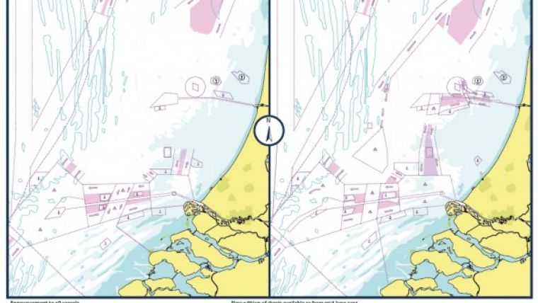
We notice that the proposed changes in Routing measures, TSS etc. as per T & P Notice 1840(P)/13 which comes into force only on August 01st 2013 has already been overlayed in the ENC chart NL400122 (Approaches to Europoort) which is now showing two TSS in the same area and also two sets of buoys (see MNW 1 & 2) in the area.
See attached screenshots from ENC and BA Chart 122 for your reference.
Unquote
The ECDIS user saw this on his screen (see Figure 2).
This looks very confusing indeed! The customer claimed to have an up-to-date ECDIS system, so that was not the problem. What else could have gone wrong? After some investigation it appeared that the user had his button [display outdated] on, which was the reason that both the old and the new situation were being displayed. There doesn’t seem to be any warning on this specific ECDIS that this button is active, which is strange. So this was more a user training issue than a technical problem. The reply to the customer was that the ENC had been encoded correctly and that the display issue would be rectified by switching off the “display outdated” option.
Why is this option available anyway? Any object encoded with the attributes DATEND and DATSTA should not normally be displayed outside its effective dates. However, to provide for effective route planning; for looking ahead during route monitoring; or for other purposes, the ECDIS should allow the mariner to view chart data for any required date and time for the purpose of reviewing pre-planned changes in chart data. When this option is in use, the mariner must be aware that the information on the display may not be correct for the actual current date and time.
Although this seems to be a user training issue (the ENC was correctly encoded), the fact that you can very easily use an ECDIS in an incorrect display is somewhat worrying… Because of the potentially dangerous situations that might occur, it was decided to issue a Notice to Mariners (Figure 3).
Immediately after the new TSS came into force, new editions of all ENCs covering the TSS were issued. In these new editions the old situation was removed, and the attribute DATSTA was removed from the component objects of the new TSS. So “normal” ENCs returned again. Phew!!!
How can the risk of something going wrong be minimised when using time-related objects in ENCs? The Hydrographic Offices should use time-related objects with caution. They have to be aware of the fact that some users and systems have difficulties using them, and inform them by using the CTNARE in the ENCs concerned. A Notice to Mariners was also issued to inform the ECDIS users (better safe than sorry). The ECDIS manufacturer should be encouraged to make sure that an ECDIS user can see on his screen that the “display outdated” option is on. This is not the case on all ECDIS systems. And what can ECDIS users do? Make sure that your system is up to date, and… training, training, training!!!
And how did the transition to the new TSS go? Very smoothly!

Value staying current with hydrography?
Stay on the map with our expertly curated newsletters.
We provide educational insights, industry updates, and inspiring stories from the world of hydrography to help you learn, grow, and navigate your field with confidence. Don't miss out - subscribe today and ensure you're always informed, educated, and inspired by the latest in hydrographic technology and research.
Choose your newsletter(s)


