High-resolution Sonar for Engineering
Integrating Multi-beam and Inertial Navigation
In the event of an incident or inclement weather such as a hurricane, an engineer may be required to assess the situation of any subsea structure. Here, the ability to produce quick, accurate and dimensionally correct survey images in an easy to read format is imperative to enable any remedial action such as vessel position, lifting, deployment of ROVs, safe working areas and diving operations.
The following ROV project was undertaken at a depth of approximately 80 metres (262 feet) on an artificial reef in the Gulf of Mexico (Eugene Island block 338 oil field) where there are several disused platforms either toppled or placed in the location in addition to various disused pipelines, debris fields, seabed disturbance from subsea construction and scars left by jack-ups and pipeline removals. The goal was to determine whether the area could be mapped accurately and quickly to provide an overview that could also be understood by non-sonar experts.
Equipment
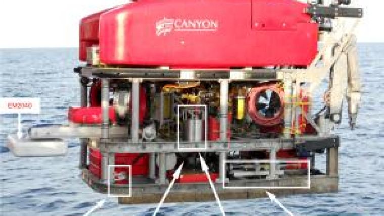
The Kongsberg EM2040 multi-beam echo sounder was chosen for the survey. It consists of a nominal 300KHz transmitter and receiver system that has the ability to adjust the operational frequency between 200 and 400KHz. It offers a choice between lower frequency and 600 metres range, or high frequency for better accuracy. The echo sounder provides 0.4 degree angular resolution in the along track and 0.7 degrees in the across whilst allowing 200 degrees of coverage with 800 beams per ping.
The EM 2040 is capable of resolving objects in the sub-decimetre range, so to synchronise several lines cleanly requires accurate subsea positioning. Acoustics alone aren’t accurate enough and need time consuming interpolation and post processing, which increases error margins. However, advanced inertial navigation systems integrated with an existing subsea positioning system offer the accuracy and enable short turnaround with no post-processing.
The Kongsberg Hydro Acoustic Inertial Navigation system (HAIN) uses the Kongsberg HiPAP system along with an Inertial Motion Unit (IMU), Doppler Velocity Log (DVL) and Digiquartz depth sensor to achieve accurate subsea positioning. By utilising modern day IMUs such as the Honeywell HG9900, accurate heading with the need for less calibration can be achieved. For this project the HiPAP 350PI system with an integrated IMU was chosen. Despite it being a portable system the HiPAP was still capable of utilising the new Cymbal technology pioneered by Kongsberg, giving far greater range resolution and improved Signal to Noise Ratio (SNR) performance. Cymbal is a Phase Shift Keyed (PSK) system which does not rely on Continuous Wave (CW) pulses – therefore allowing more bandwidth with a larger Signal to Noise Ratio (SNR). With the integrated HG9900 the need for any calibration is removed allowing for a fast mobilisation and more effective use of vessel time.
With multi-beam data the acquisition is normally the easy part; it is the processing that is more complex. Resolving pitch, roll, heading, latency, navigation and sound velocity errors can be incredibly time consuming. The HAIN system provided all inputs so the previously mentioned compensations were completed in real-time, resulting in raw data that required very little manipulation before it could be used by the engineers.
Mobilisation
Work class ROVs are a common tool during subsea inspection and construction preparation. Unfortunately, different models feature different interfacing protocols for transferring the sensor data from the ROV to the surface and into the topside computer. One of the project requirements was that the system could be mobilised quickly on an ROV of opportunity without prior knowledge. For this project, it was understood that any ROV should have a spare fibre for data transfer.
On the above assumption it was decided to supply a tested multiplexer interface for all the equipment and manufacture all the subsea cables so the ROV would only supply the power and one fibre for all the sensor equipment. The multiplexer chosen for the operation was the Seatronics RTS Gen 5. The integration of all systems was checked in the workshop in co-ordination with the ROV operator who was supplying a Schilling Quest compact electric work class ROV (Fig.1). The vessel used during the project was the ACO Jessica Moore.
Operations and Timing
As with most high accuracy mapping systems, calibrations are needed to be performed prior to the operational phase. This includes determining the DVL and IMU relative angles for the HAIN inertial navigation system, which is done by the ROV performing a line with various speeds and headings. The time for this was about 30 minutes. In addition, the multi-beam needs to know the angular installation of the transducer heads relative to the heading pitch and roll unit – in this case the IMU. This is calculated by the ROV performing a standard multi-beam patch test. It took about 2 hours to complete this calibration and because the HiPAP 351P requires no calibration itself, this was a fast mobilisation.
The priority was to get an overview of a given area measuring 1600 metres by 600 metres. No prior information was given by the client except the presence of platforms that had been toppled or partially toppled – the exact location of each was unknown.
The initial survey was carried out at an altitude of 50 metres to obtain maximum coverage and to prevent the ROV from running into any debris. Five lines were run with an acquisition time of about six hours. From the initial results (Fig. 2) the toppled platforms, and one standing, can be clearly seen as well as the jack-up’s footprints. Partially buried pipelines can be made out in the surface, however, due to the relatively small surface protrusion they are not clearly defined.
The Kongsberg EM2040 not only has the benefits of sub-centimetre imaging which is geographically referenced (Fig. 2) - it also provides other advanced features. By using the raw amplitude of each returning beam and plotting this geographically, a map of the seafloor can be created, often referred to as backscatter. Hard surfaces such as structures will get a very strong signal response whereas the softer muddy sediments will absorb more of the energy of the sonar pulse, giving a weaker response. All this information was available from the initial 6 hour data collection. It is interesting to note that backscatter can also be used to determine the seabed type, whether sand, gravel or another type. If backscatter instead of depth information is displayed, the pipelines that were previously not clearly defined, can be viewed with greater clarity.
With the initial survey complete, the surveyor can select areas to be viewed in greater detail. In this project the areas subject to further investigation included the platforms, debris field and pipelines. Figure 3 depicts a toppled platform as data points from several 10 – 20 metre passes. The image is created by the ROV running three lines, one each side of the platform and one over the top. The data was acquired in less than 1 hour and the data presentation was ready within half an hour.
In addition to the bottom reflection and the backscatter, the sonar also records the reflection that occurs in the water on the way to the seabed. This is called water column data. Technology pioneered by Kongsberg in the early 2000s enables the user to ascertain whether any obstacles in the water column have been missed by the bottom tracking algorithm. Essentially objects such as steel wires or masts which could be a potential navigation hazard for a vehicle may not give a strong enough reflection to be assigned a data point. Water column processing (Fig. 4) enables a dataset to be reassessed, to indicate all possible problems prior to organising an operation.
All this illustrates the type of information a project engineer on such a job could have available within a short space of time to enable him to start planning operations. The pipeline survey was achieved with a single survey line run at a 10 metre altitude at about 1 knot. The purpose of this run was to ascertain whether the integrity of a pipeline could quickly be determined for position, buckling or free-spans.
Further Applications
While the EM2040 multi-beam is effective when used to assess post hurricane damage, the use of the current solution extends well beyond this. Despite becoming common place in the Gulf of Mexico, the practice of deploying old jack-ups and platforms for artificial reefs in other areas still raises fairly large concerns over how the structures will affect the surrounding environment, so the ability to repeat high-resolution surveys to assess the potential change to the seafloor whether through scarring or sand bank creation is critical. The EM2040 coupled with the HAIN system allows fast deployment from virtually any platform and will allow the user to survey even the deepest man-made reef in high resolution.
Additionally, the water column imaging provides benefits when assessing any missed objects or obstructions. Already known for investigating biomass in the water column, customers are also now using the equipment to investigate hydrocarbon (Fig. 5).
The solution for this project was mobilised quickly and proved that it could produce clear datasets for presentation in a short time scale and in a form that a non-sonar expert could easily interpret. The data was able to be used almost immediately by engineers and further post-processing can be done to give 3D fly-through visualisation, analysis of water column biomass, seabed classification and true 3D scaled reference frames. This quick to deploy and provide results system will be used for a number of applications going forward, and could help to support the use of artificial reefs and the benefits they provide across the globe.

Value staying current with hydrography?
Stay on the map with our expertly curated newsletters.
We provide educational insights, industry updates, and inspiring stories from the world of hydrography to help you learn, grow, and navigate your field with confidence. Don't miss out - subscribe today and ensure you're always informed, educated, and inspired by the latest in hydrographic technology and research.
Choose your newsletter(s)


