How airborne bathymetric Lidar helps to protect marine environments
Discovered by tiger sharks, validated by technology
Hexagon is working with Beneath The Waves, a conservation NGO, to help protect marine environments in the Bahamas. Using bathymetric airborne Lidar solutions, researchers are able to map, study and quantify the region’s endangered seagrass ecosystem. This process can determine the extent, composition, condition and volume of seagrass, allowing the team of researchers to plan conservation of the ecosystem as a ‘blue carbon’ habitat. This project will potentially launch one of the world’s most impactful nature-based mitigation efforts while protecting biodiversity in the Caribbean islands.
R-evolution, Hexagon’s sustainability business venture, is leading the way in accelerating the transition to a sustainable global economy by identifying and attracting capital to finance business opportunities that benefit the environment and society. For one project, R-evolution takes advantage of cutting-edge airborne bathymetric solutions from Leica Geosystems, part of Hexagon, to promote decarbonization, the protection of coastal ecosystems and the preservation of biodiversity.
The world has seen an exponential increase in carbon emissions, resulting in drastic changes to the climate and threatening life on Earth. Carbon sinks are one powerful resource nature has at its disposal for keeping carbon dioxide levels at bay. For too long, however, the carbon discussion has centred around land-based carbon sinks, such as forests, while neglecting the biggest and most global storage depot on Earth: the ocean.
Blue carbon habitats
‘Blue carbon’ ecosystems refer to coastal and marine vegetated habitats – such as seagrass meadows, salt marshes and mangrove forests – that sequester and store carbon from the atmosphere and ocean. Seagrass, in particular, captures carbon dioxide more efficiently than land-based forests do. Moreover, since most carbon is stored in soil and sediments, it can remain there for millennia if left undisturbed. Nevertheless, despite their crucial role in mitigating climate change, seagrass meadows remain among the least recognized and least protected ecological habitats. The lack of data on the distribution of seagrass meadows poses a significant obstacle to conservation and restoration efforts.
Shark study reveals unexpected insights
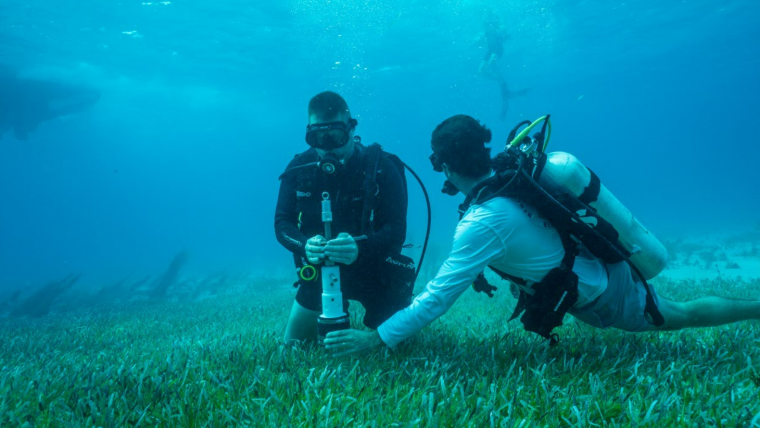
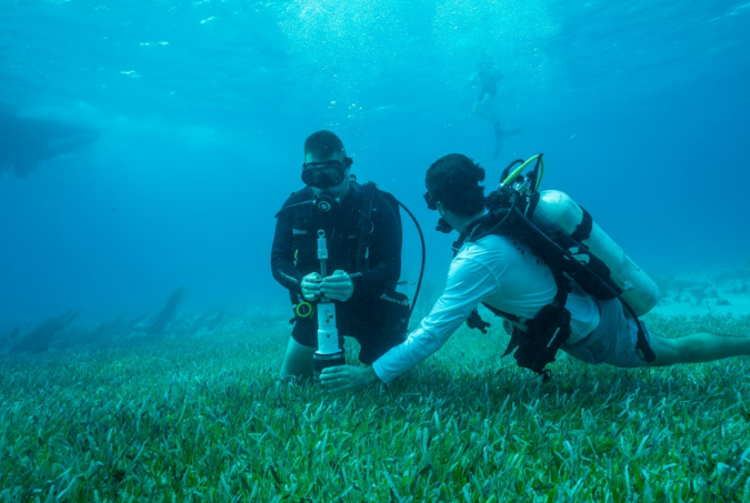
In the Bahamas, home to a large seagrass ecosystem and also a designated shark sanctuary, scientists were studying sharks’ movements on behalf of the conservation NGO called Beneath The Waves. Their research unexpectedly revealed that tiger sharks spend a large portion of their life patrolling and foraging dense seagrass meadows. Using this insight, the organization leveraged a combination of sensor-tagged sharks, satellite data, marine vessel surveys and scuba divers to further investigate and map the extensive seagrass meadows of the Caribbean. This mapping project was an essential first step in learning more about the little-known ocean habitat. However, to protect and restore the blue carbon sinks, the conservancy’s findings needed to be validated with high-positional accuracy and datasets that can provide efficient, year-on-year change detection and monitoring.
Mapping large areas with vessels, divers and sharks is such a long and resource-heavy process that it is not an option for large-scale projects. To map, study and quantify the threatened seagrass meadows of the Caribbean islands at scale, Beneath The Waves teamed up with R-evolution. This sustainability business venture leverages airborne bathymetric Lidar technologies from Leica Geosystems, part of Hexagon, to capture details about the vital habitat, including its extent and composition. Bathymetric surveying supports environmental monitoring by mapping and classifying submerged vegetation and habitat to assess aquacultures and study marine ecology and hydrodynamics.
The benefits of airborne surveys
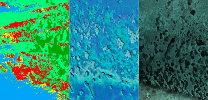
Airborne surveys could improve the efficiency, resolution and accuracy of the mapping process, covering the same area in just a few days and thus offering a more time-efficient and cost-effective solution. Because it is easily repeatable, it also forms an excellent basis for year-on-year change detection and monitoring. In addition, Lidar point clouds provide 3D elevation and land classification information with higher positional accuracy and spatial resolutions compared to the data quality generated with, for example, satellite imagery. Airborne bathymetry systems are optimized for shallow-water data collection, so they are ideal for mapping seagrass which grows primarily in water depths of 30 metres or less.
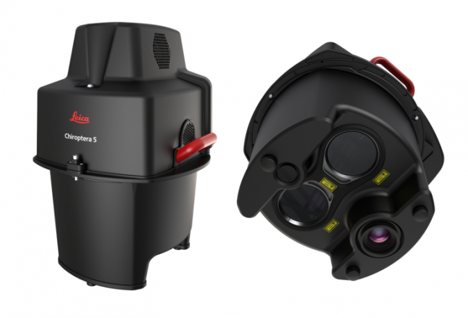
Collecting high-quality bathymetric data with the Leica Chiroptera airborne Lidar sensor was routine for the team at Hexagon, but it was key to leverage that data to generate the insights required for this project. A development team had been researching ways to automate the processing of the acquired data. Apart from the bathymetric data the sensor collects, the initial project team had other sources of information on hand: researchers on the vessel gathered luminosity data, the divers could provide information about the seabed such as the type of vegetation and collect coring samples, and the sharks that had been equipped with cameras provided additional photo imagery.
Loss compensation and normalization
After the data capture, the bathymetric Lidar full-waveform information fused with image radiometric information from the Chiroptera sensor systems was compensated for losses in the atmosphere, water surface and water volume and thereafter normalized with the measured depth. The result was a high-resolution, consistent seabed dataset that included both radiometric and spatial information of the vegetation. By feeding this data into deep-learning artificial intelligence (AI) classification algorithms, the team were able to identify different seabed types, vegetation species and density. The sediment core samples provided information about the amount of carbon each vegetation type stores. By combining this information, they could map the carbon captured by the seabed automatically and at scale.
In December 2021, the team used the Chiroptera 4X to map the area. Leica Geosystems has since introduced the high-performance airborne sensor Leica Chiroptera-5, which offers a 40% higher point density, a 20% increase in water depth penetration and improved topographic sensitivity compared to previous generations so that future surveys of this and other regions will generate even more detailed hydrographic maps at even faster speed.
The preliminary results look very promising, and the team hopes that the accuracy and resolution of the bathymetric Lidar will provide an invaluable new data source for seabed carbon mapping. Combining the marine expertise of Beneath The Waves with the innovation and technological know-how of Hexagon, the collaborative project expects to yield groundbreaking results for blue carbon conservation and to potentially launch one of the world’s most impactful nature-based mitigation efforts. This offers an opportunity to protect biodiversity in the marine habitats of the Caribbean islands and generate new value streams simultaneously.

Value staying current with hydrography?
Stay on the map with our expertly curated newsletters.
We provide educational insights, industry updates, and inspiring stories from the world of hydrography to help you learn, grow, and navigate your field with confidence. Don't miss out - subscribe today and ensure you're always informed, educated, and inspired by the latest in hydrographic technology and research.
Choose your newsletter(s)


