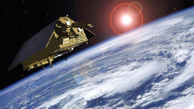
How Copernicus Sentinel-6 Will Monitor the Oceans
Rate of Sea-level Rise Accelerates
With millions of people around the world at risk from rising seas, it is essential to continue measuring the changing height of the sea surface to ensure that decision makers are equipped to take appropriate mitigating action. Copernicus Sentinel-6, a new satellite, will take the lead in charting sea-level change.
Sentinel-6 carries a radar altimeter to provide high-precision and timely observations of the topography of the global ocean. This information is essential for the continued monitoring of changes in sea level, a key indicator of climate change. It is also essential for operational oceanography.
ESA’s director of Earth Observation Programmes, Josef Aschbacher, said at the presentation of the satellite in Germany in November 2019, “With global sea level rising at shocking rates, Copernicus Sentinel-6 will take the lead in providing systematic measurements of sea level so that the worrying trend in sea-level rise can be closely monitored and key information provided for important policy decisions.”
Differences in Seawater Density
Previous missions have shown how the sea level rose by about 3.2mm on average a year between 1993 and 2018, but more alarmingly, that the rate of rise has been accelerating over the last few years. It is now rising at 4.8mm a year. However, this average number masks big differences as it is not rising at the same rate everywhere. In fact, while in some places it is rising as much as 10mm a year, in other places it is falling by 10mm a year. There are many reasons for this imbalance such as differences in local gravity, freshwater discharge from rivers and differences in seawater density.
The information that we get from satellites is essential for understanding how fast our seas are rising so that decision makers are equipped to take appropriate mitigating action. Satellites carrying altimeter instruments systematically measure the height of the sea surface so that sea-level rise can be closely monitored.
Consequences of Climate Change
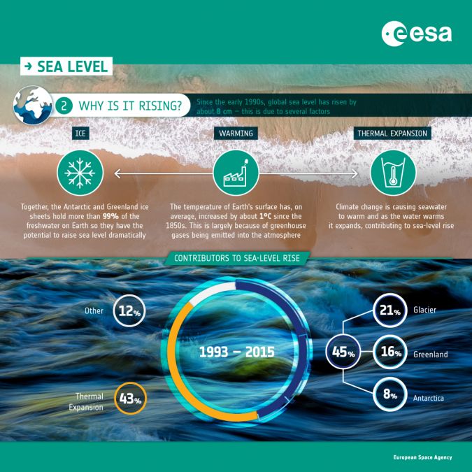
Caused mainly by warming ocean waters, melting glaciers and diminishing ice sheets, sea-level rise is one of the most severe consequences of climate change. With millions of people around the world at risk from rising seas, it is essential to continue measuring the changing height of the sea surface so that decision makers are equipped to take appropriate mitigating action.
Thermal expansion is the biggest single cause of sea-level rise as a consequence of climate change, but ice loss from the continental glaciers and from the polar ice sheets is also one of the most critical drivers of our rising seas. Ice loss from glaciers, Greenland and Antarctica accounts for about 45% of sea-level rise. Another cause is discharge from water bodies on land, but how much this contributes to sea-level rise is more uncertain. With many millions living in coastal communities around the world, sea-level rise is a major concern.
Sea-surface Topography
The Copernicus Sentinel-6 satellite will map up to 95% of the Earth’s oceans every 10 days. The mission will use a radar altimeter to observe changes in sea-surface topography with centimetre precision, providing insights into global sea levels, the speed and direction of ocean currents and ocean heat storage.
These measurements are not only critical for monitoring our rising seas, but also for climate forecasting, sustainable ocean resource management, coastal management and environmental protection, the fishing industry, and more.
Sea-level Variability
Sentinel-6 will map up to 95% of the Earth’s ice-free ocean every 10 days in order to monitor sea-level variability. The radar altimeter will also measure the ocean surface topography – the hills and valleys of the ocean – that help us to map ocean currents. In addition, it will provide estimates of wind speed and wave height for maritime safety.
The mission builds on heritage from the Jason series of satellites, Copernicus Sentinel-3 and ESA’s CryoSat mission. It will also complement ocean information from Sentinel-3, the other member of the Copernicus altimeter constellation.
Measuring the Height of the Ocean
Satellites carrying radar altimeters record the surface topography along the satellite’s ground track. They precisely measure a satellite’s height above water, land or ice by timing the interval between the transmission and reception of very short radar pulses. This is the only technology that can measure, systematically and globally, changes in the height of the ocean – and is therefore essential for monitoring sea-level rise.
Sentinel-6 is being realized in close cooperation between ESA, NASA, the European Commission, EUMETSAT and NOAA. The satellite will be launched in November 2020 from the Vandenberg Air Force Base in California, US, on a Falcon-9. It will be the first time that ESA cooperates, through NASA, with the private US aerospace manufacturer SpaceX, which was founded in 2002 by Elon Musk.

Facts and Figures
The global mean sea level has risen about 8–9 inches (21–24 centimetres) since 1880, with about a third of that coming in just the last 25 years. The rising water level is mostly due to a combination of meltwater from glaciers and ice sheets and the thermal expansion of seawater as it warms. In 2018, the global mean sea level was 3.2 inches (8.1 centimetres) above the 1993 average – the highest annual average in the satellite record (1993–present).
The global mean water level in the ocean rose by 0.14 inches (3.6 millimetres) per year from 2006 to 2015, which was 2.5 times the average rate of 0.06 inches (1.4 millimetres) per year throughout most of the twentieth century. By the end of the century, the global mean sea level is likely to rise at least one foot (0.3 meters) above 2000 levels, even if greenhouse gas emissions follow a relatively low pathway in the coming decades.
In some ocean basins, sea-level rise has been as much as 6–8 inches (15–20 centimetres) since the start of the satellite record. Regional differences exist because of natural variability in the strength of winds and ocean currents, which influence how much and where the deeper layers of the ocean store heat.
Past and future sea-level rise at specific locations on land may be more or less than the global average due to local factors: ground settling, upstream flood control, erosion, regional ocean currents, and whether the land is still rebounding from the compressive weight of Ice Age glaciers.
Source: National Ocean Service (US)
About the ESA
The European Space Agency (ESA) calls itself Europe’s gateway to space. Its mission is to shape the development of Europe’s space capability and ensure that investment in space continues to deliver benefits to the citizens of Europe and the world. ESA is an intergovernmental organization, created in 1975.
www.esa.int

Value staying current with hydrography?
Stay on the map with our expertly curated newsletters.
We provide educational insights, industry updates, and inspiring stories from the world of hydrography to help you learn, grow, and navigate your field with confidence. Don't miss out - subscribe today and ensure you're always informed, educated, and inspired by the latest in hydrographic technology and research.
Choose your newsletter(s)


