Hydrographic Society Russia
Graduation
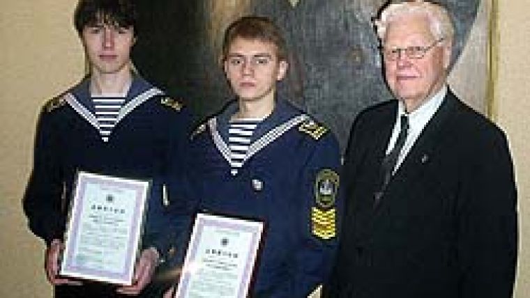
On 5 March, the graduation ceremony of a new group of young hydrographers took place at the Admiral Makarov State Maritime Academy (AMSMA) in St Petersburg (Russia).
Shortly before the ceremony, the chief of the AMSMA Arctic Faculty nominated graduates Alexey Kiprushin and Vladimir Dmitriev for the Professor A.P. Belobrov Diploma, which was instituted by the HSR. Both graduates were exceptional students and have already gained experience of working in hydrography as well as having produced very good work during there degree. It was with great pleasure that president Nikolay N. Neronov awarded these diplomas.
Anniversary
On 31 March, HSR president and honoured worker of the Russian Federation Dr Prof. Nikolay Neronov celebrated his 80th birthday. On this day, a celebratory meeting took place at the State Research Navigational and Hydrographic Institute of the Ministry of Defence (Russia). There were many congratulatory speeches and gifts presented. Dr Alexandr Alkhimenko presented to the HSR President an Order in the name of the famous Russian hydrographer Boris Vilkitsky. Neronov is a hydrographic expert in Russia. Despite his age, he is full of energy, and still possesses a good memory and capacity to work. His knowledge is broad and deep. Hydrographers of all levels value his opinion. After the official part of the meeting, a buffet was held for about 100 guests. A few days later, Dr Prof. Neronov invited his relatives, friends and some HSR members to one of St Petersburg’s finest restaurants, where they could once again celebrate his health and well-being, and honour his accomplishments for the Russian hydrographic service.
Australasian Hydrographic Society
The winner of the AHS Education Award 2008 is Malcolm Lindsay. Malcolm is working towards a PhD at the University of Melbourne within the Zoology Department and his project satisfies all the parameters of this award. The title of his research project is ‘The larval recruitment and oceanographic dynamics of the Wilson’s Promontory Marine National Park, Australia’. The research data should provide significant aid to marine park managers and will be of particular value in the case of an oil spill in the containment and clean-up operations. The project is directly linked to Parks Victoria, the marine park management body, encouraging real outcomes for marine park management.
We are now accepting applications for the 2009 AHS Education Award: please see the Society webpage (website 1) for the application form and further details. The closing date for entries is 10 December 2009.
East Australia Region
The EAR held a general meeting on Tuesday 12 May 2009 at Bruttour International Head Office in Hornsby, NSW. The meeting was well attended with active discussion throughout the night, mainly on the topic of education. A motion was carried to form an EAR Education Sub-group. This Group consists of four members who will look into solving some of the education and training issues for the region.
Members were shown a DVD inviting surveyors to attend the FIG 2010 World Congress to be held in Sydney on 11–16 April 2010. The Congress will be a fantastic event, giving hydrographic surveyors from all around the world the opportunity to interact. Commission 4 has active working group members who will be presenting their group papers and results in Sydney. Continuing Professional Development points for Australasian certified surveyors will also be a huge attraction for the event. The call for abstracts for papers closes on 22 September 2009. The Sponsorship and Exhibition prospectus is also available: please see the official website (website 2).
Following the meeting, a presentation was given by Mr Jasbir Randhawa on behalf of Mr Robert Ward on the roles and functions of the International Hydrographic Organization (IHO). The talk was interesting and informative for all members. Dinner and drinks were kindly supplied by Bruttour International.
New Zealand Region
The Fugro Larry Robbins Scholarship for 2008 was awarded to Taryn Clare Murray at a ceremony at the University of Otago on 9 May 2009. Murray is a final-year student of the Category A Programme in Hydrographic Surveying. Her dissertation is on the subject of aquaculture reform legislation in New Zealand. This is the fourth award made by Fugro to students of surveying since its initiation.
Hydrographic Society Benelux
The Netherlands Institute of Navigation and the HSB jointly organise workshops on a regular basis. On Friday 27 March 2009, one such workshop took place at the National Aerospace Laboratory in Amsterdam. The topic was GLONASS, the Russian satellite positioning system. From the five presentations, the topic could be viewed from different perspectives, although there was a certain amount of redundancy in the information.
The speakers were Kees de Jong (Fugro), Frank Boon (Septentrio), Jean Paul Henri (06-GPS), Jeroen Zomerdijk (Leica) and Rob Bik (Trimble-Geometius), and the meeting was chaired by Hans Visser (Fugro).
Although GLONASS was launched at the same time as GPS, it never achieved the same popularity, mainly because of the difficulty for the Russians to keep a full configuration in space. In the last few years, a number of new satellites have been launched and there are now 20 active satellites, which is nearly a full configuration of 24. As a result, there is growing interest in GLONASS from professional users (terrestrial and hydrographical). The motto ‘more is better’ was mentioned by some of the speakers.
The GLONASS system has some fundamental differences from GPS, which causes problems for manufacturers. All GPS satellites use the same frequencies and identify themselves by a unique ‘signature’, whereas GLONASS satellites use different frequencies. This has an impact not only on identification by receivers, but also on the precision of positioning in real-time kinematic mode.
However, the combination of both GPS and GLONASS has some advantages. Due to the larger inclination angle of GLONASS and the larger total number of satellites, the combination performs much better in urban areas. In addition, the precision of the combined systems is slightly better than for GPS alone. Furthermore, the distance to a reference station can in theory be increased to about 50km compared with 30km for GPS alone. For this reason some reference networks now also offer correction signals for GLONASS. A discussion on GPS and GLONASS would not be complete without mention of future developments in Galileo (Europe) and Compass (China). It is not possible to predict the future, but further improvements in satellite positioning are very likely.
Despite the full programme and the sometimes very specialised information, the afternoon was very informative for the 75 attendees. The presentation is available for download from the HSB website (website 3).

Value staying current with hydrography?
Stay on the map with our expertly curated newsletters.
We provide educational insights, industry updates, and inspiring stories from the world of hydrography to help you learn, grow, and navigate your field with confidence. Don't miss out - subscribe today and ensure you're always informed, educated, and inspired by the latest in hydrographic technology and research.
Choose your newsletter(s)


