Hydrographic Surveying Supporting the Search for MH370
Last week, the MH370 Safety Investigation Report was presented by the Ministery of Traffic of the Malaysian Government. On 8 March 2014, the Malaysian Airlines aircraft went missing in the Indian Ocean. Since then, a big search operation has taken place aiming to track down the fuselage in the waters, but the aircraft was never found. The search gave, however, tons of additional data of the ocean floor to the underwater mapping community. Hydro International has followed the developments with great interest and below, you can find articles and news with great building blocks of oceanographic and hydrographic data.
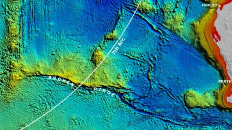
Increased-resolution Bathymetry in the Southeast Indian Ocean
Kim Picard, Walter Smith, Maggie Tran, Justy Siwabessy, Paul Kennedy
The disappearance of Malaysian Airlines flight MH370 on 8 March 2014 led to a deep ocean search effort of unprecedented scale and detail in the remote southeastern Indian Ocean. Between June 2014 and January 2017, two mapping phases took place: (1) a shipborne bathymetric survey, and (2) a higher-resolution search in areas where accurate mapping of the seafloor was required to guide the detailed underwater search aimed at locating the aircraft wreckage. The latter phase used sidescan, multibeam and synthetic aperture sonar mounted on towed or autonomous underwater vehicles (AUVs). This article describes the mapping of the area where the aircraft was expected to be found. Read more >
Could Adaptive Pingers Have Aided Search for MH370?
Justin Manley, Thomas DiCicco
Although the number of aircraft lost at sea is not very high, in the past years a number of aircraft have literally been lost at sea. With the recently renewed search for Malaysian Airlines flight 370 (MH370), one wonders about the technology in the underwater location of aircraft, and other high value objects. Underwater Locator Beacons (’ULBs’ or ‘pingers’) are used for this, either on the airframe itself or on the black box. Technological advancements to allow better detection are proposed. Read more >
Ocean Infinity Donates 120,000 Square Kilometres of Data to Seabed 2030 Project
The Nippon Foundation-GEBCO Seabed 2030 Project, which aims to map the entirety of the world’s ocean floor by 2030, is to receive 120,000 square kilometres of data from Texas-based surveying company Ocean Infinity. The data will be incorporated into the latest version of the global map of the ocean floor. So far, only a fraction of the ocean floor has been mapped with direct measurement. Read more >
MH370 Search Discovers Shipwreck
Fugro Equator’s deep tow system detected a cluster of small sonar contacts in the southern part of the search area for missing flight MH370, 12 nautical miles to the east of the 7th arc. The sonar data was carefully analysed and categorised as Class 2: ‘of potential interest but unlikely to be related to MH370’. Analysis of the images revealed that the debris was indeed man-made, but indicated that it was actually the wreck of a ship. This wreck is previously uncharted and the imagery will be provided to expert marine archaeologists for possible identification. Read more >
Discovery of MH370 Part Confirms Ocean Current Models
A part from the MH370 aeroplane feared lost in the Indian Ocean on 8 March 2014 was found recently on the island of La Réunion. According to the Australian Transport Safety Bureau (ATSB) which is leading the search, this is consistent with the current underwater search area in the southern Indian Ocean where exhaustive analysis has concluded the aircraft entered the water. Read more >

Value staying current with hydrography?
Stay on the map with our expertly curated newsletters.
We provide educational insights, industry updates, and inspiring stories from the world of hydrography to help you learn, grow, and navigate your field with confidence. Don't miss out - subscribe today and ensure you're always informed, educated, and inspired by the latest in hydrographic technology and research.
Choose your newsletter(s)


