IHO Standards
Standardisation of hydrographic methods and the provision of information is a fundamental part of achieving the IHO objectives. The Organization began developing standards and guidelines intended for use by the wide community of professionals with responsibilities in the fields of hydrography, nautical cartography, safety of navigation and related matters.
The objectives of the International Hydrographic Organization (IHO) are:
• the co-ordination of the activities of national hydrographic offices (HOs)
• the greatest possible uniformity in nautical charts and documents
• the adoption of reliable and efficient methods of carrying out and exploiting hydrographic surveys
• the development of the sciences in the field of hydrography and the techniques employed in descriptive oceanography.
IHO standards are compiled and maintained by various Working Groups made up of volunteer representatives from IHO Member States (usually from HOs), together with expert contributors representing industry and the various other stakeholder groups. Standards must be authorised by a majority of IHO Member States before they can enter into force.
Most important IHO standards:
The IHO Publications are arranged under the following groups:
B - Bathymetric Publications (Mainly related to GEBCO).
C - Capacity Building Publications
M - Miscellaneous Publications (including Basic Documents)
P - Periodic Publications
S - Standards and Specifications
S-44 – Standard for Hydrographic Surveys
S-44 sets out the standards required for the execution of hydrographic surveys for the collection of data primarily intended for the compilation of nautical charts to be used for the safety of surface navigation and the protection of the marine environment.
S-5 and S-8 – Standards for Education and Training
S-5 and S-8 are maintained by the FIG/IHO/ICA International Advisory Board and set out the minimum standards required for international recognition of training courses in hydrographic surveying (S-5A & S-5B) and nautical cartography (S-8A & S-8B). The standards also provide the procedures for submission of documentation and a complete model syllabus.
S-32 – Hydrographic Dictionary
A permanent working group maintains the IHO Hydrographic Dictionary (S-32), which now contains almost 7,000 definitions of words and terms used in hydrography and associated activities.
M-12 and M-3 – Standards for Nautical Publications
M-12 provides a structure for the publication of List of Lights and Fog Signals. M-3 is the consolidated Resolutions of the IHO. M-3 contains detailed guidance on the composition of nautical publications such as Sailing Directions.
S-4 and S-11 – Standards for Paper Charts
S-4 provides the chart specifications for the compilation and presentation of nautical charts issued by charting authorities such as HOs, together with agreed symbols and abbreviations. S-11 provides specific regulations for the co-ordination and production of INT charts.
S-52, S-57, S-61, S-63 – Standards for Electronic Charts
S-57 describes the data standard to be used for the exchange of digital hydrographic data generally. The product specification for electronic navigational charts (ENCs) is described in an Annex to S-57. S-63 provides the standard for data protection (encryption) of ENCs, while S-52 provides specifications and guidance regarding the issuing of ENCs, their display in an electronic chart display and information system (ECDIS) and their updating. S-61 defines the minimum requirements for a raster navigational chart (RNC) to be used in the Raster Chart Display System (RCDS) Mode of Operation, as described in the IMO Performance Standards for ECDIS.
Full list and availability of IHO standards
|
Reference |
Description |
Downloads |
|
S-4 |
Regulations for International (INT) Charts and Chart Specifications of the IHO (English: Edition 4.9.0, March 2021 - Publication date: April 2021) |
|
|
S-4 |
Associated Documents (INT 1, INT 2, INT 3): |
|
|
|
INT 1 Symbols and Abbreviations used on Paper Charts (current English version, Edition 8, 2020) (UKHO Terms of Use, Conditions of Release and Disclaimer - See also Other Publications) |
|
|
|
INT 1 Símbolos, Abreviaturas y Términos Utilizados en las Cartas, (versión española, Edición 6, 2018) |
|
|
|
INT 2 Borders, Graduation,Grids and Linear Scales (Edition 4, 2007) |
|
|
|
INT 3 Use of Symbols and Abbreviations (Edition 5, 2011) |
|
|
|
For further information on emerging or changing requirements for nautical charts, please consult the – Nautical Cartography Bulletins |
|
|
S-5A |
Standards of Competence for Category "A" Hydrographic Surveyors (Edition 1.0.2, June 2018) |
|
|
S-5B |
Standards of Competence for Category "B" Hydrographic Surveyors (Edition 1.0.1, June 2017) |
|
|
S-8A |
Standards of Competence for Category "A" Nautical Cartographers (Edition 1.0.1, June 2018) |
|
|
S-8B |
Standards of Competence for Category "B" Nautical Cartographers (Edition 1.0.0, September 2017) |
|
|
|
Companion documents : a) Guidelines for the Implementation of the Standards of Competence for Hydrographic Surveyors and Nautical Cartographers (Edition 2.1.2, July 2021) b) Frequently Asked Questions (FAQ) (Edition 1.0.0, March 2020) |
|
|
S-11 |
Guidance for the Preparation and Maintenance of International (INT) Chart and ENC Schemes and Catalogue of International (INT) Charts |
|
|
|
Part B - INTernational Chart Web Catalogue, Associated Webservices and User Manuals
|
|
|
S-12 |
Standardization of List of Lights and Fog Signals (June 2004 - Corrections to June 2006) |
|
|
S-23 |
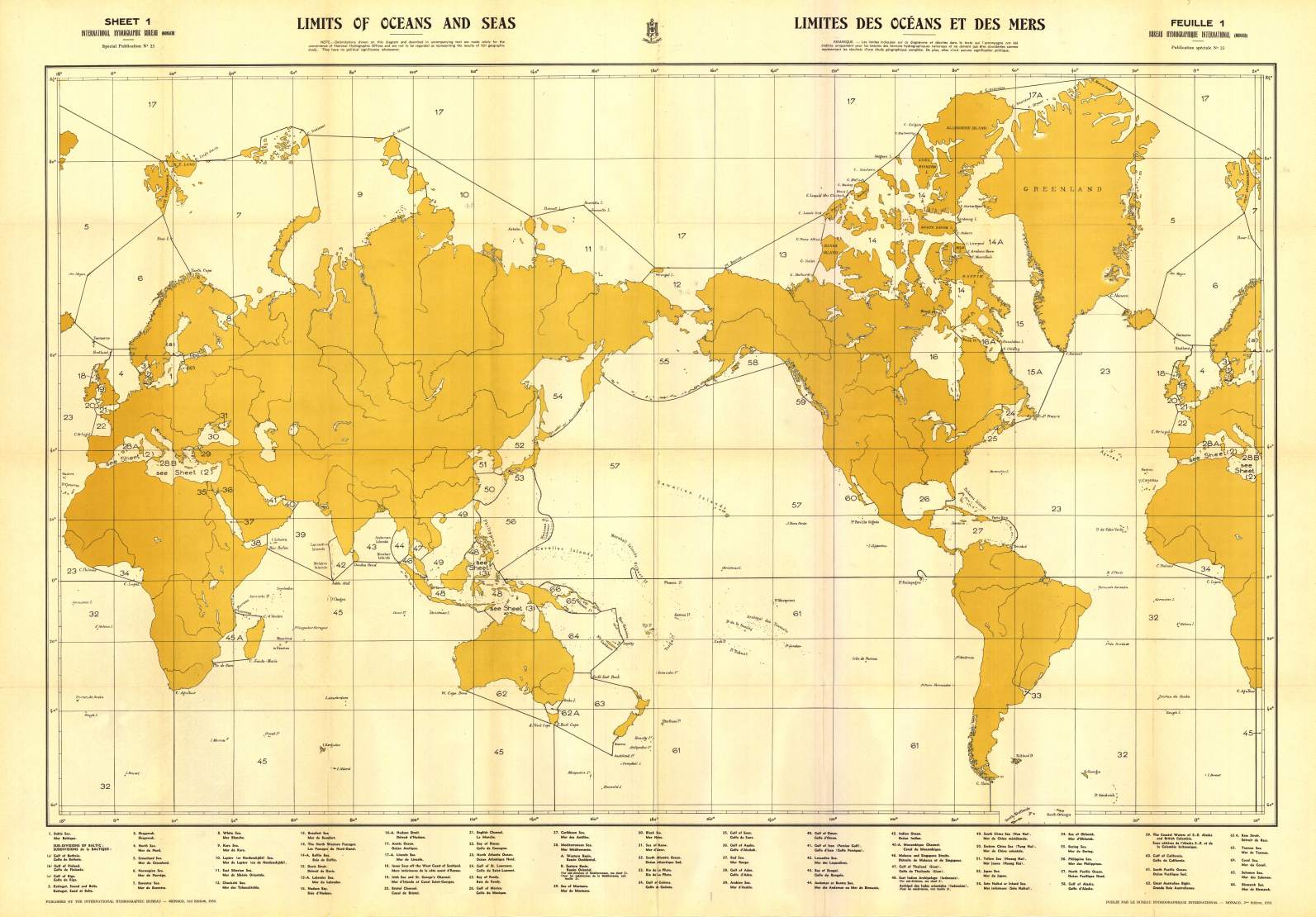
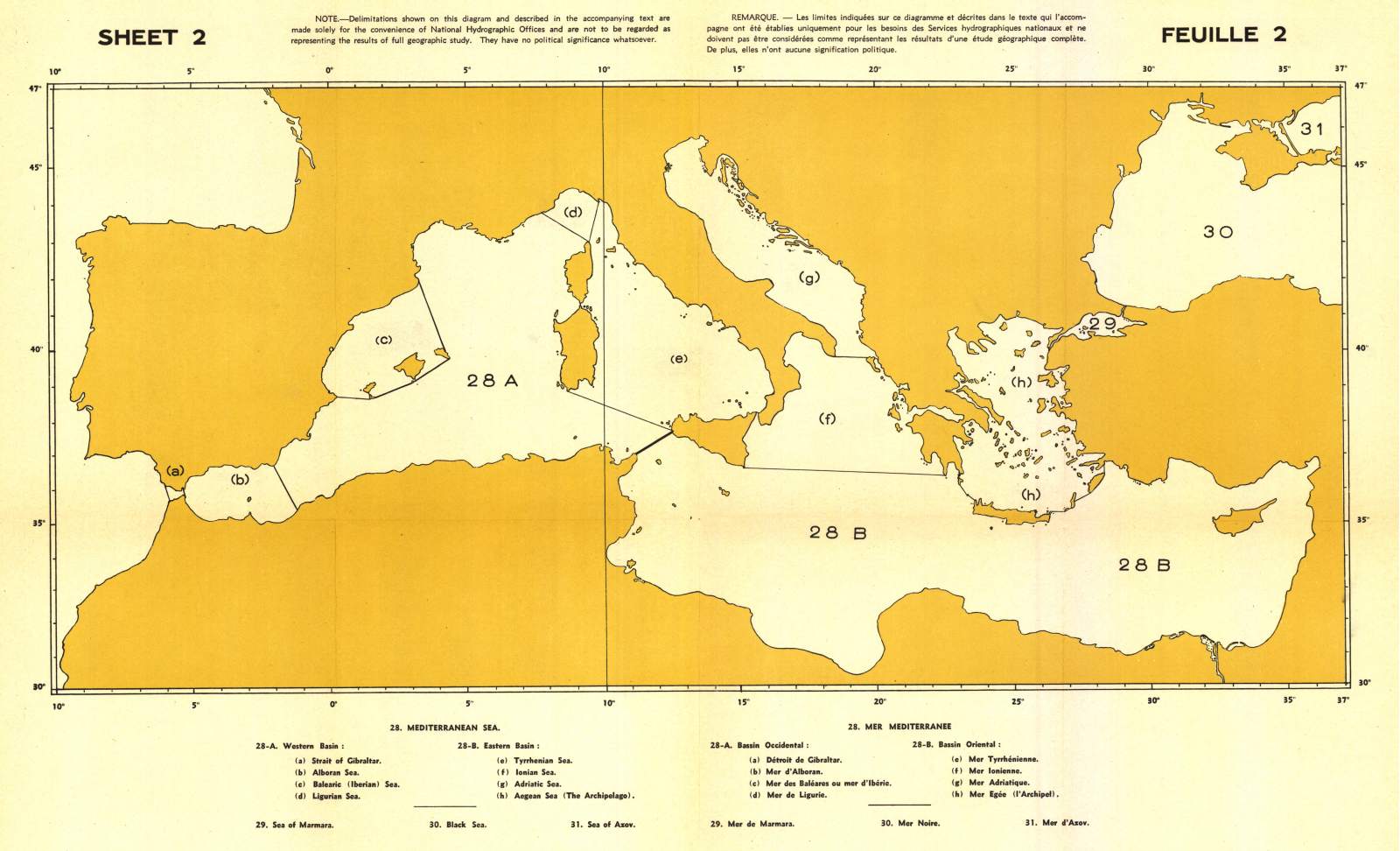
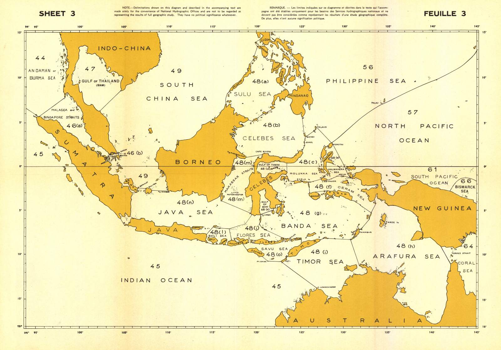
Limits of Oceans and Seas (1953). Sheet maps 1, 2 and 3 |
|
|
|
S-23 Component Documents : Please note: This document, and higher resolution sheet maps, are also available from the IHO, on CD ROM. |
|
|
S-32 |
Hydrographic Dictionary Diccionario Hidrográfico 水文词典 Kamus Hidrografi |
|
|
S-32 App1 |
Hydrographic Dictionary - Glossary of ECDIS Related Terms - Inserted in the WIKI versionI |
|
|
S-44 |
IHO Standards for Hydrographic Surveys (Edition 6.0.0, September 2020)
Normas de la OHI para los Levantamientos Hidrográficos (Edición 6, septiembre del 2020) * The Chinese translation of S-44 - IHO Standards for Hydrographic Surveys, is kindly provided by the China Maritime Safety Administration. |
Chinese * |
|
S-49 |
Standardization of Mariners' Routeing Guides (Edition 2.1.0, September 2020) |
|
|
S-52 |
Specifications for Chart Content and Display Aspects of ECDIS (Edition 6.1(.1), October 2014 - with Clarifications up to June 2015) Annex A to S-52 - IHO ECDIS Presentation Library |
|
|
|
S-52 Component Documents: |
|
|
S-53 |
Joint IMO/IHO/WMO Manual on Maritime Safety Information (January 2016) Manual conjunto OMI/OHI/OMM relativo a la Información sobre Seguridad Maritima (2016) ----------------------------- Appendix 1 List of NAVAREA and Sub-Area Coordinators- Operational points of contact (see COMSAR Circ 58) |
|
|
S-57 |
IHO Transfer Standard for Digital Hydrographic Data (Edition 3.1.0, November 2000) - Main Document |
|
|
|
S-57 Component Documents:
NOTE: The IHO standard S-57 contains the outdated terms, Master and Slave. These terms were widely use within computing when the standard was first published. However, the IHO have recognised these terms are no longer acceptable, and all future IHO standards will no longer reference them. For backwards compatibility and to avoid any unintended consequences the IHO will not update the current edition of S-57 to modify any of the language used. |
|
|
S-58 |
ENC Validation Checks (Edition 6.1.0, September 2018) NOTE: The IHO standard S-58 contains the outdated terms, Master and Slave. These terms were widely use within computing when the standard was first published. However, the IHO have recognised these terms are no longer acceptable, and all future IHO standards will no longer reference them. For backwards compatibility and to avoid any unintended consequences the IHO will not update the current edition of S-58 to modify any of the language used. S-58 Associated References: |
|
|
S-60 |
User´s Handbook on Datum Transformations involving WGS 84 (July 2003 - Last correction August 2008) |
|
|
S-61 |
Product Specification for Raster Navigational Charts (RNC) (January 1999) |
|
|
S-62 |
List of IHO Data Producer Codes (current edition)
Cumulative list of changes to S-62 (last change 14 January 2022) |
|
|
S-63 |
IHO Data Protection Scheme (Edition 1.2.1, March 2020) |
|
|
|
S-63 / S-100 Security Scheme documents (listed below) are available from the Security Scheme Page. These documents include:
|
|
|
S-64 |
IHO Test Data Sets for ECDIS (Edition 3.0(.3), December 2020) |
|
|
S-65 |
ENCs: Production, Maintenance and Distribution Guidance (Edition 2.1.0, May 2017) |
|
|
S-65 Annex A |
High Density (HD) ENC Production and Maintenance Guidance (Edition 1.0.0, January 2020) |
|
|
S-66 |
Facts about Electronic Charts and Carriage Requirements (Edition 1.1.0, January 2018) |
|
|
|
Related IMO Circulars:
Japanese translation of S-66 and associated IMO Circulars is provided courtesy of the Japan Hydrographic Association (JHA). |
|
|
S-67 |
Mariners’ Guide to Accuracy of Depth Information in Electronic Navigational Charts (ENC) (Edition 1.0.0, September 2020)
Guía de los Navegantes sobre la Exactitud de las Cartas Náuticas Electrónicas (ENC) (Edición 1.0.0, septiembre 2020 * The Chinese translation of S-67 - Mariners’ Guide to Accuracy of Depth Information in Electronic Navigational Charts (ENC), is kindly provided by the China Maritime Safety Administration. |
Chinese * |
|
S-97 |
IHO Guidelines for Creating S-100 Product Specifications (Edition 1.1.0, June 2020) |
|
|
S-99 |
Operational Procedures for the Organization and Management of the S-100 Geospatial Information Registry (Edition 1.1.0, November 2012) |
|
|
S-100 |
IHO Universal Hydrographic Data Model (Edition 4.0.0, December 2018) S-100 based Product Specifications Please note: the S-100 (Part 15) Security Scheme applications document for OEMs and Data Servers are available from the Data Protection Scheme S-100 based Product Specifications may be based on a previous Edition of S-100. For reference, previous Editions of S-100 are available here: |
|
|
IHO Registry |
IHO Geospatial Information (GI) Registry The IHO GI Registry is an online resource that comprises several Registers which contain organised lists of hydrographic related information |
|
|
IHO S-100 based Product Specifications (S-1XX): |
||
|
S-101 |
ENC Product Specification (Edition 1.0.0, December 2018) |
|
|
S-102 |
athymetric Surface Product Specification (Edition 2.0.0, October 2019) |
|
|
S-111 |
Surface Currents Product Specification (Edition 1.0.0, December 2018) |
|
|
S-121 |
Maritime Limits and Boundaries Product Specification (Edition 1.0.0, October 2019) |
|
|
S-122 |
Marine Protected Areas (Edition 1.0.0, January 2019) |
|
|
S-123 |
Marine Radio Services (Edition 1.0.0, January 2019) |
|
|
S-127 |
Marine Traffic Management (Edition 1.0.0, December 2018) |
|
|
S-129 |
Under Keel Clearance Management (Edition 1.0.0, June 2019) |
|
|
|
A complete list of all S-100 based Product Specifications, including Product Specifications in development and published, is maintained here |
|

Value staying current with hydrography?
Stay on the map with our expertly curated newsletters.
We provide educational insights, industry updates, and inspiring stories from the world of hydrography to help you learn, grow, and navigate your field with confidence. Don't miss out - subscribe today and ensure you're always informed, educated, and inspired by the latest in hydrographic technology and research.
Choose your newsletter(s)


