Investigating change at historic shipwreck sites
Combining repeat hydrographic and geophysical surveys with computational fluid dynamics
Shipwrecks are an integral part of our underwater landscape. According to UNESCO, there are three million wrecks worldwide, and these create various marine spatial planning challenges. To address these challenges, their long-term stability on the seabed needs to be understood. A PhD project conducted at Ulster University attempted to understand the factors affecting wreck sites on the seabed, through high-resolution hydrographic and geophysical surveys combined with detailed desk-based assessment involving computational fluid dynamics simulations.
The importance of understanding change at shipwreck sites
Many historical shipwrecks are viewed as war graves, as the ships were lost in tragic circumstances in naval warfare in the First and Second World Wars. They also act as time capsules, providing insight into technological solutions of their time and life on board. Besides their heritage and archaeological values, shipwrecks are known as hotspots of marine biodiversity, which also attracts sport divers and fishers, and can be associated with pollution threats. With many offshore renewable energy sites being planned for development, shipwrecks are also frequently treated as impediments to ocean engineering and navigational hazards. On the other hand, having rested on the seabed for so long, they are good proxies of how man-made structures interact with the natural ocean environment. Despite these diverse interests from many parties, most wrecks remain largely unresearched.
Shipwrecks undergo deterioration, the pace of which is regulated by a set of environmental and anthropogenic factors commonly referred to as site formation processes. Understanding these factors is important to develop effective management strategies for these fragile underwater archaeological sites. High-resolution digital elevation models resulting from detailed hydrographic and geophysical surveys can aid site characterization and monitoring and our understanding of the complex factors influencing the submerged legacy on the seabed.
Scope of the project
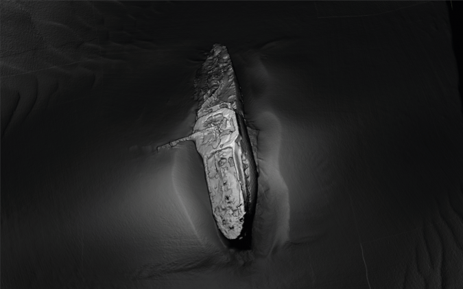
The PhD project at Ulster University investigated 12 shipwrecks in the Irish Sea, all over 100 years old. Repeat hydrographic and geophysical survey data, an oceanographic model and computational fluid dynamics were used to study site formation processes, focusing on hydrodynamic forces and seabed changes. High-resolution multibeam echosounder data was used to create detailed 3D models of the sites, which were subsequently applied not only to conduct archaeological research but also provided a means to show otherwise inaccessible shipwrecks to the wider public. An example of a 3D model of one of the shipwrecks is shown in Figure 1. The method developed made it possible not only to capture the shipwrecks, but also the ambient seabed bathymetry in a time-efficient manner. This is important, as it allows the detection of change in the shipwreck structures and the seabed around them.
Detecting change in shipwreck structures
Capturing changes in wreck structures is no easy task. Commonly, photogrammetric survey techniques are used in archaeology to capture artefacts, allowing the creation of effective 3D renders. Such surveys can be repeated and the resulting models compared, thus recording changes at centimetric scales. However, this approach is time-consuming for large objects such as shipwrecks, which require thousands of photographs prior to constructing the 3D models. Additionally, the sites selected for this study were all located in relatively inaccessible, deep waters with highly restricted water visibility. For these reasons, high-resolution acoustic marine remote-sensing techniques were chosen for the PhD project.
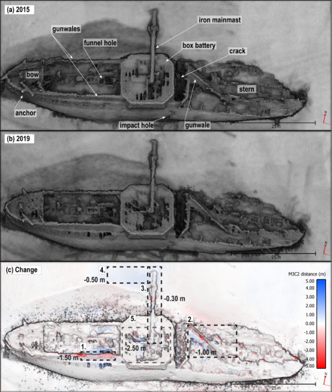
Specifically, the Irish Marine Institute’s research vessel Celtic Voyager, equipped with a Kongsberg EM2040 multibeam echosounder, was used to acquire high-resolution data repeatedly in 2015 and 2019. The shipwrecks were scanned with multiple slow passes over their structures at varying angles (Westley et al., 2019), providing millions of elevation data points in just a few hours of surveying. Subsequent data processing and the application of 3D visualization techniques revealed structural changes as shown in Figure 2.
Apart from recording intricate structural details such as the impact hole, which caused the sinking of the vessel, a comparison of the data acquired in 2015 and 2019 allowed an assessment of the damage sustained by the wreck in this period. For example, the gunwales deformed and one of them slid down (Fig. 2c, 1 and 2) and the mainmast dropped, causing further erosion of the seabed around it.
The information extracted from such models can serve to investigate shipwrecks as process-response systems at some equilibrium state. This state can be disrupted and the resulting change of one structural element can cause further disorganization at the site before it reaches another equilibrium state. The factors causing the initial disruption are either natural or anthropogenic and can be investigated further using the data acquired in situ and modelled data.
Detecting change in the surrounding seabed
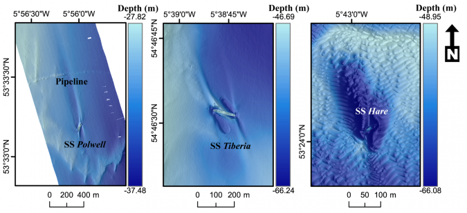
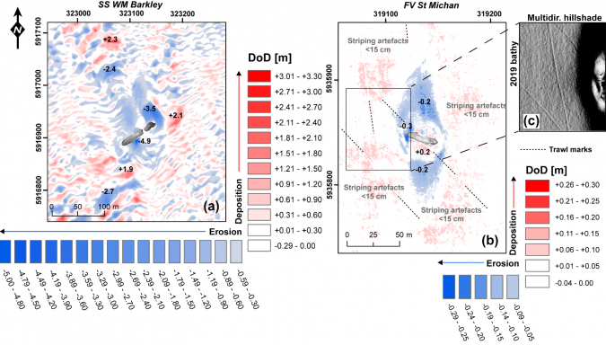
Shipwrecks may be surrounded by sediment waves of various sizes or by rock outcrops, and because wrecks act as obstacles affecting local current flows, they often cause seabed scour. This process can result in deep depressions around a shipwreck, exposing its parts. A quick look at the DEMs of some shipwreck sites reveals that their presence can cause extensive disruption to the seabed, significantly changing the bathymetry around them (Fig. 3).
Seabed change may displace and damage a wreck or cause its complete or partial burial or exposure. Therefore, seabed change at the sites selected for the project was recorded in situ in detail (Majcher et al., 2021). The sites, situated in various parts of the Irish Sea, reflect a variety of oceanographic and geological conditions: tidal currents, wave patterns, sediments and geomorphology differ significantly between the sites. Some of the studied sites experienced extreme changes, for example the seabed height changed by up to 4.9m near one wreck in four years (Fig. 4a), while others remained almost static during the same period (Fig. 4b). An interesting observation was noted at the relatively static site of the fishing vessel wreck St. Michan, where trawl marks directly intersecting the site appeared between 2015 and 2019 (Fig. 4b, c). Fishing activities conducted in the area may therefore have contributed to the state of the shipwreck on the seabed.
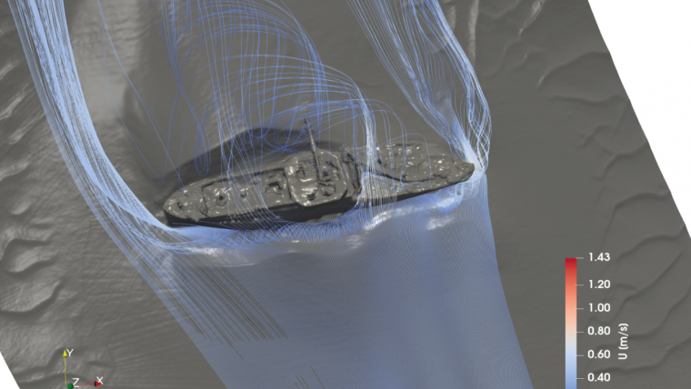
Understanding change using computational fluid dynamics
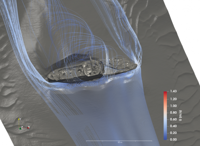
The observed wreck and seabed changes were investigated further using numerical models (Majcher et al., 2022). Output from the Regional Ocean Modeling System, provided by the Marine Institute Ireland, and the acquired multibeam echosounder data were used with computational fluid dynamics to simulate current flows at the sites. The simulations showed that wreck structures do indeed cause substantial changes to local current flows, triggering the development of vortices and enhancing shear stresses at the seabed (Fig. 5).
The distribution of flow-exerted forces and vortices at the wreck sites help to draw conclusions about their future preservation potential. It was observed that some of the sites are prone to further changes, as they are subject to high shear stresses and turbulence, which promote seabed erosion and re-deposition. This therefore shows which sites may be prone to accelerated disintegration.
Conclusion
The PhD project aimed to extend the knowledge about site formation processes affecting heritage shipwreck sites. A combination of time-effective marine remote sensing and oceanographic and numerical modelling methods was applied to understand wreck sites as process-response systems. This made it possible not only to record and understand past changes, but also to make future predictions. The developed approach can help to establish management strategies for the sites, backed by an in-depth, data-informed assessment.
This is important, considering how many shipwrecks there are on the seabed around the world. UNESCO estimates that there are three million shipwrecks worldwide, which are often densely distributed in semi-enclosed, busy seas such as the Irish Sea (around 18,000 shipwrecks in total around Ireland according to the Underwater Archaeology Unit in Dublin) and the Baltic Sea (8,000–10,000 shipwrecks according to the Baltic Marine Environment Protection Commission). While many of these are considered to be historically important and part of our common underwater cultural heritage, they often pose environmental pollution risks. Knowing how these sites change under various natural and anthropogenic processes is therefore important for many parties.
Acknowledgements
This research was made possible thanks to the collaboration of a team of multidisciplinary scientists from diverse scientific backgrounds: my supervisors Rory Quinn (Ulster University), Ruth Plets (Flanders Marine Institute in Belgium) and Chris McGonigle (Ulster University) and collaborators/advisors Fabio Sacchetti (Marine Institute Ireland), Thomas Smyth (University of Huddersfield), Mark Coughlan (Irish Centre for Research in Applied Geosciences) and Kieran Westley (Ulster University).
The PhD project emerged as a result of the Integrated Mapping for the Sustainable Development of Ireland's Marine Resource (INFOMAR) project’s ship-time application grants: APP-CV15021, CV16031 titled ‘World War I shipwrecks in the Irish Sea: commemoration, visualization and heritage management’, APP-CV19027 titled ‘Geohazard Investigation in the Irish Sea using Seismic and Seabed Mapping Techniques’ and Ulster University’s Vice-Chancellor’s Research Studentship.
References
Majcher, J., Plets, R., & Quinn, R. (2020). Residual relief modelling: digital elevation enhancement for shipwreck site characterisation. Archaeological and Anthropological Sciences, 12(6). https://doi.org/10.1007/s12520-020-01082-6
Majcher, J., Quinn, R., Plets, R., Coughlan, M., McGonigle, C., Sacchetti, F., & Westley, K. (2021). Spatial and temporal variability in geomorphic change at tidally influenced shipwreck sites: The use of time-lapse multibeam data for the assessment of site formation processes. Geoarchaeology, 36, 429–454.
Majcher, J., Quinn, R., Smyth, T., Plets, R., Mcgonigle, C., Westley, K., Sacchetti, F., & Coughlan, M. (2022). Using difference modelling and computational fluid dynamics to investigate the evolution of complex, tidally influenced shipwreck sites. Ocean Engineering, 246, 110625.
Westley, K., Plets, R., Quinn, R., McGonigle, C., Sacchetti, F., Dale, M., McNeary, R., & Clements, A. (2019). Optimising protocols for high-definition imaging of historic shipwrecks using multibeam echosounder. Archaeological and Anthropological Sciences, 11, 3629–3645.

Value staying current with hydrography?
Stay on the map with our expertly curated newsletters.
We provide educational insights, industry updates, and inspiring stories from the world of hydrography to help you learn, grow, and navigate your field with confidence. Don't miss out - subscribe today and ensure you're always informed, educated, and inspired by the latest in hydrographic technology and research.
Choose your newsletter(s)


