
Jamie McMichael-Phillips Appointed Director of The Nippon Foundation-GEBCO Seabed 2030 Project
Jamie McMichael-Phillips, the new director of The Nippon Foundation-GEBCO Seabed 2030 Project, has now taken up his position in leading one of the most challenging projects of the next decade, the mapping of the entire ocean floor by the year 2030. The announcement of his appointment was made at a conference held at the Royal Society in London, in October. Entitled ‘From Vision to Action’, the meeting, which brought together some of the world’s leading scientists and maritime organizations, was convened to mark the progress made in the two years since Seabed 2030 was launched, and to look ahead to the remaining challenges in ‘mapping the gaps’ in understanding the seafloor.
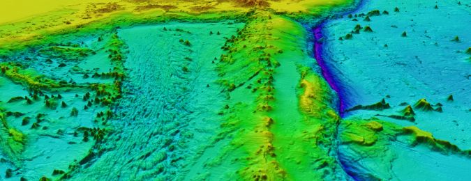
Definitive Map of the World’s Oceans
Seabed 2030 is an international initiative, supported by over 100 maritime organizations. The project has four Regional Centres, based in strategically-located areas of the world, which feed data into a Global Centre hosted at the British Oceanographic Data Centre in Southampton, UK. Since the publication of the 2014 GEBCO map, Seabed 2030 has seen a doubling of the bathymetric data available to produce the definitive map of the world’s oceans. The total contributions to the map are equivalent to the landmass of the entire African continent. GEBCO is the only organization with a mandate to map the entire ocean floor.
McMichael-Phillips has been described as 'a leader and hydrographer who successfully made the transition from the rank of Captain in Britain’s Royal Navy to Head of Partnering and Engagement for the UK Hydrographic Office'. As a chartered surveyor, hydrographer and mariner, he has had extensive experience in strategy and policy formulation, together with international engagement, negotiation, leadership and mentoring – gained during his Royal Navy career and in civilian life.
Geospatial Data for Navigational Safety
He has managed government to government relationships for the exchange of geospatial data for navigational safety, and for the benefit of the wider Blue Economy. He has led on outreach and capacity building of fledgeling organizations in marine data collection, assessment and cartography.
Prior to his Seabed 2030 appointment, McMichael-Phillips chaired – for over nine years – the International Hydrographic Organization’s Worldwide Electronic Navigational Charts (ENC) Database working group, responsible for monitoring the global footprint of electronic charts needed for safe navigation by commercial shipping.
Shape of the Ocean
On his appointment, he commented “the shape of the ocean is fundamental to how we predict climate change, tsunami modelling, ocean currents circulation, weather patterns and how we sustainably manage the oceans. In the last four weeks, data-sharing agreements have been signed with PGS, the Norwegian-based marine geophysical company, and the Schmidt Ocean Institute, which will share all its mapping data with us,” says McMichael-Phillips. “Schmidt alone will add more than one million square kilometres of the ocean floor to Seabed 2030’s data resources.”
About The Nippon Foundation-GEBCO Seabed 2030 Project
The Nippon Foundation, a private, non-profit foundation, was established in 1962 for the purpose of carrying out philanthropic activities, using revenue from motorboat racing. The Foundation’s overall objectives include social innovation, assistance for humanitarian activities and global ocean management. Its philanthropic ideals embrace social development and self-sufficiency, and it pursues these principles by working to improve public health and education, alleviate poverty, eliminate hunger and help disabled people.
The General Bathymetric Chart of the Oceans (GEBCO) partners The Nippon Foundation in the Seabed 2030 Project. GEBCO is a joint project of the International Hydrographic Organization (IHO) and the Intergovernmental Oceanographic Commission (IOC) of UNESCO – the United Nations Educational Scientific and Cultural Organization. It is the only intergovernmental organization with a mandate to map the entire ocean floor. It has its origins in the GEBCO chart series initiated in 1903 by Prince Albert I of Monaco and aims to provide the most authoritative, publicly-available bathymetric datasets for the world’s oceans.
Complete Mapping of the World’s Oceans
The Nippon Foundation-GEBCO Seabed 2030 Project is a collaborative project between The Nippon Foundation and GEBCO to inspire the complete mapping of the world’s oceans by 2030 and to compile all bathymetric data into the freely-available GEBCO Ocean Map. Working under the auspices of the International Hydrographic Organization (IHO) and UNESCO-Intergovernmental Oceanographic Commission (IOC), GEBCO has a 100-year history of ocean floor mapping. Seabed 2030, launched at the United Nations Ocean Conference in 2017, is building a global community of ocean mappers, hydrographers, scientists, industry and the public to discover and publish all existing bathymetric data. Seabed 2030 advocates for new mapping expeditions to ‘map the gaps’ in our knowledge of the seafloor and provide the world with the definitive map of world bathymetry.

Value staying current with hydrography?
Stay on the map with our expertly curated newsletters.
We provide educational insights, industry updates, and inspiring stories from the world of hydrography to help you learn, grow, and navigate your field with confidence. Don't miss out - subscribe today and ensure you're always informed, educated, and inspired by the latest in hydrographic technology and research.
Choose your newsletter(s)


