Launch of NF-GEBCO Seabed 2030 Ambition for Ocean-floor Mapping
NF-GEBCO Seabed 2030 – which will facilitate the complete mapping of the ocean floor by the year 2030 – was announced by Mr Yohei Sasakawa, chairman of The Nippon Foundation (NF), at the UN Ocean Conference in New York on 6 June 2017. This is a collaborative project between the General Bathymetric Chart of the Oceans (GEBCO) and The Nippon Foundation. NF-GEBCO Seabed 2030 is the only long-term international project with a mandate to map the entire ocean floor.
The Nippon Foundation will contribute USD18.5 million for the first ten years of the project. The aspiration is for Seabed 2030 to compile all available and newly collected bathymetric data into a high-quality, high-resolution digital model of the ocean floor and to promote international efforts to collect new data.
Four Regional Data Assembly and Coordination Centres
The work will be done through the establishment of four Regional Data Assembly and Coordination Centres (RDACCs) and a Global Data Assembly and Coordination Centre (GDACC) based at the British Oceanographic Data Centre, National Oceanography Centre, United Kingdom. The RDACCs will be based at: the Alfred Wegener Institute, Germany, covering the Southern Ocean; the National Institute of Water and Atmospheric Research, Wellington, New Zealand, covering the South and West Pacific Ocean; the Lamont Doherty Earth Observatory, Columbia University, USA, covering the Atlantic and Indian Oceans; and Stockholm University, Sweden, for the North Pacific and Arctic Ocean.
Crowdsourcing
Seabed 2030 will take responsibility for bringing collected depth data together, find and highlight the unmapped gaps and help coordinate mapping by working with the established ocean mapping community within academia, offshore industry and government. A particular initiative will be to work with the fishing industry to increase the amount of data from fishing vessels that operate worldwide as well as recreational and merchant vessels. A working group with industry is planned through the World Ocean Council. The initiative of the International Hydrographic Organisation (IHO) on Crowd Source Bathymetry, of which Seabed 2030 is a part, will also be a contributor.
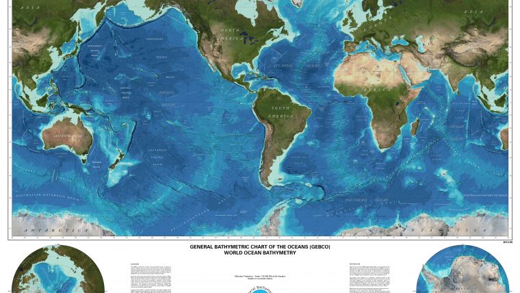
Seventy percent of the Earth is covered by the world’s oceans for which the bottom topography (bathymetry) is far less known than the surfaces of Mercury, Venus, Mars and the moons of several planets, including Earth’s. Yet knowledge of the shape of the seafloor is crucial for understanding ocean circulation patterns relating to regional and global ocean-atmosphere processes that distribute heat between the tropics and the poles – a key component of Earth’s climate system. Detailed measurements of depth are also critical for predicting tsunami inundation. In addition, ocean bathymetry is important for the study of tides, wave action, sediment transport, underwater geo-hazards, cable routing, fisheries management, resource exploration, establishment of sovereign rights over the extension of the continental shelf and military and defence applications.
Dynamics of Ocean and Ocean Floor
According to GEBCO, “the more data we acquire about the details of the shape of the seabed, the more we recognise that the ocean and its floor are more dynamic than we ever thought. Given the vast expanse of the oceans of our planet, the goals of Seabed 2030 can only be achieved by international coordination and collaboration with regard to data acquisition, assimilation and compilation. Seabed 2030 therefor has a vital role to play in helping to coordinate and initiate new bathymetric surveys that target unmapped areas of our oceans. This remains a substantial challenge. With the ultimate objective of leaving no features of the world ocean floor larger than 100 metres unmapped, a series of targets with varying resolutions as a function of water depth will be set. But it will require a major international effort by the world community to reach the ultimate goal”.

Value staying current with hydrography?
Stay on the map with our expertly curated newsletters.
We provide educational insights, industry updates, and inspiring stories from the world of hydrography to help you learn, grow, and navigate your field with confidence. Don't miss out - subscribe today and ensure you're always informed, educated, and inspired by the latest in hydrographic technology and research.
Choose your newsletter(s)


