Netherlands and USA Cooperate in Environmental Security Certification Programme
Partrac GeoMarine, a Houston, USA, based Marine Survey and Consultancy company, has announced the award by the US Department of Defense (DoD) of a 3-year contract to demonstrate a new tool for mapping the in situ distribution of Contaminants of Concern (COCs) in aquatic sediments. The award is part of the Environmental Security Technology Certification Program (ESTCP), the DoD's environmental technology demonstration and validation programme.
Partrac, together with its Netherlands based partner Medusa Explorations, will deploy the new instrument at up to three contaminated DoD Superfund sites to map the distribution of COCs such as Polycyclic Aromatic Hydrocarbons (PAHs), Polychlorinated Biphenyls (PCBs) and heavy metals (e.g. mercury, lead, zinc, etc).
From Europe to the USA
Dr Patrick Friend, Partrac GeoMarine’s Business Development Consultant (Americas), said “We are really excited to be bringing this new instrument over from Europe to be used in the US. This technology is a potential game-changer in the way that contaminated sediments are mapped, and can offer significant cost and safety benefits over traditional contaminated sediment sampling and mapping methods”.
Dr Ronald Koomans, Director of Medusa Explorations, said “We have trialled this technology in Europe over the past few years, and have successfully mapped the distribution of contaminated sediments in ports, harbours, and rivers. We can use the tool not only for new site investigations but also for post-remediation monitoring of sites that have been capped, for example, to test capping efficiency.”
Aquatic Gamma Spectrometer
The new instrument coming to the USA is a specially adapted aquatic gamma spectrometer developed by Medusa Radiometrics. This is a passive instrument that measures the natural geochemical signature of sediments which can then be related to the sediment contaminant content. The tool works equally well for both naturally deposited and dredged sediments in all aquatic environments - marine, riverine and lacustrine. It has a number of other applications including rapid in situ mapping of silt content and grain-size distribution, and even the quasi-real-time mapping of sediment transport.
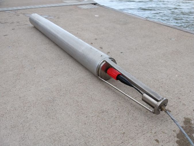
Photo: Aquatic gamma spectrometer.

Value staying current with hydrography?
Stay on the map with our expertly curated newsletters.
We provide educational insights, industry updates, and inspiring stories from the world of hydrography to help you learn, grow, and navigate your field with confidence. Don't miss out - subscribe today and ensure you're always informed, educated, and inspired by the latest in hydrographic technology and research.
Choose your newsletter(s)


