Port ECDIS
Enhanced ENC Standard for Port Operations
The management of larger vessels within the confined, shallow and/or tidal environments of ports requires precise chart information. However, current ECDIS and Inland ECDIS standards do not meet the more stringent regulations in terms of up-to-dateness, scale, accuracy (especially of the topography) and chart objects and attributes required for such port operations. Port ECDIS is the name of the successful work package of the EU-funded project Effective Operations in Ports which aimed to design, develop and test enhanced Port Electronic Navigation Charts (PENCs). With the carriage of ECDIS becoming mandatory for deep-sea vessels within a couple of years, the adoption of new enhanced standards for ports is vital.
Chapter V of the 1974 International Maritime Organisation (IMO) Safety of Life at Sea Convention (SOLAS V) states that all vessels (regardless of size) must carry approved nautical charts and publications to display, plan and monitor the ship's position during a voyage. An Electronic Chart Display and Information System (ECDIS) may meet such requirements if type approved and based on up-to-date official (that is, issued by a government-authorised Hydrographic Office) Electronic Navigational Charts (ENCs). According to a statement by the IMO, it is expected that carriage of an approved ECDIS will be mandatory on deep-sea vessels by the beginning of 2012 (see Hydro International, December 2008).
An ECDIS is not only used for navigation but also in Vessel Tracking Management Information Systems (VTMIS) and Marine Simulators. In addition, inland ECDIS has been developed for navigation on river systems. In both applications, standards developed by the IMO precisely define the rules and regulations necessary for safe maritime and river navigation. However, current ECDIS and inland ECDIS standards do not cover the more stringent regulations in terms of scale, accuracy (especially of the topography) and chart objects and attributes required for operations within ports.
Port Operations
The management of larger vessels within confined, shallow and/or tidal waters, including navigation in narrow channels, lock passage, docking operations, berthing and turning manoeuvres, requires precise chart information. Access to up-to-date (sometimes in real-time) topographic and bathymetric information which is of a greater accuracy than that required for maritime and inland ENCs (see Table 1) is important. Since individual port authorities are responsible for safe navigation and port maintenance, they normally produce their own charts and/or fair sheets without adhering to any global standards. This lack of uniformity can be eradicated with the introduction of ‘Port ENCs' (PENCs), since ports are
usually also government-authorised companies.
Consider for example the official maritime ENC of the Port of Hamburg (Germany), website 1. It meets all the relevant ECDIS-related standards and fulfils the requirements of marine navigation. However, maritime ENCs cannot be used for the above-mentioned operations within the port area as the chart is too small in scale, it does not have enough bathymetric detail and the horizontal accuracy of topographic features (e.g. quay walls, piers, pontoons) is poorly defined.
Efforts
The EU-funded Effective Operations in Ports (EFFORTS), website 2, project was launched in order to determine how European port operations could be optimised. Work on the 3.5-year project, which comprised three subprojects (Navigation in Ports, Ports and Environments and Port Organisation), was completed in October 2009.
Port ECDIS is the third work package of the first subproject, Navigation in Ports, which aimed to improve the safety and efficiency of navigation in ports under conditions of reduced manoeuvring space (or larger vessels) and increased traffic. WP1.3 was led by Hamburg Port Authority (HPA) with the goal of developing an enhanced ENC standard for use in ports. HPA produced a complete Port ENC dataset for the Port of Hamburg. Other partners in this work package were CARIS BV (geospatial software solutions) and SevenCs (specialist in digital navigation and electronic nautical charting). Together, the partners developed visualisation tools to display the Port ENC components.
Port ENC Requirements
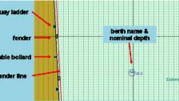
A Port ENC is not simply a higher accuracy ENC; it is also an information system geared towards different port users. A questionnaire issued at the start of the EFFORTS project determined the different types of users of enhanced ENCs (roughly classed as navigation and maintenance users) and their requirements. The overwhelming response was that maritime and inland ENCs are not suitable in terms of scale, accuracy, up-to-dateness and attributes for port operations; Figure 1 depicts some of the additional objects created especially for ports. In addition, data can also be required on a real-time basis which is not currently available with maritime ECDIS.
Main (or Group 1) users include pilots, harbour masters (e.g. VTMIS), water police, dredgers, vessel crew, salvage crew, surveyors and HOs. As well as the standard information currently available (e.g. port infrastructure, passage information, meteorological, hydrological and traffic data), Group 1 users also indicated that bathymetric and reference model data were required. Such users often have to view the data in three dimensions (3D), implying that additional source data such as Digital Terrain Models (DTMs) to represent bathymetry and Triangulated Irregular Networks (TINs) to model the reference channel may be useful.
The typical scale of ENCs for ports around the world ranges from 1:10,000 (Southampton) and 1:15,000 (Hamburg) to 1:25,000 (Rotterdam). Data suitable for a Port ENC should be of a scale starting at 1:5000 (comparable to the above-mentioned port fair sheets) and topography should be of an accuracy of +/- 0.1m.
Port ENC Features
In addition to the normal ENC and inland ENC objects and features, a Port ENC has several extensions which are needed to fulfil the port requirements and comply with the large-scale environment (Figure 2). Three additional datasets will be integrated into the Port ENC dataset: gridded bathymetry; a reference or channel model (CRM); and a bathymetric ENC (bENC).
Gridded bathymetric data comprise 3D raster data where each grid node has a 3D coordinate. The data will utilise the bathymetry-attributed grid (BAG) format, a non-proprietary file format for storing and exchanging bathymetric data developed by the Open Navigation Surface Working Group. The grid size (typically 1m square) can be defined by the user.
The reference or channel model represents the theoretical port/harbour bottom surface which must be maintained (dredged) by the port authority. A comparison of the current depth situation (gridded bathymetry) with the maintenance surface (CRM) in real-time could be easily generated, highlighting areas which are too shallow or too deep.
A bENC is a new S-57-based chart product for display in Electronic Chart Systems (ECS). The contents of a bENC are ideally based on the latest hydrographic surveys and contain no other information but high-density bathymetry and the relevant metadata. Typically, a bENC contains S-57 feature objects of type depth contour, spot soundings, depth area and some meta-objects but no other objects representing nautical information.
Figure 3 depicts the integration of a Port ENC with a bENC. Figure 4 is an image of absolute depth, as the Port ENC has been combined with gridded bathymetry data. A ‘difference chart' is depicted in Figure 5, generated by calculating the difference between the current depth situation and the channel model. In Figure 5, green indicates areas of correct depth, yellow implies that depth is within a defined tolerance and red highlights areas which are too shallow.
Standardising PENCs
Individual ports and harbours are currently responsible for their own operations and activities. This includes compiling regular surveys of the area and presenting the results as, for example, fair sheets or large-scale hydrographic maps. These charts are issued as base information to the harbour master, pilots and other maintenance or safety users. Since the resolution and type of data available varies from one port to another, it is desirable to apply standards such as IHO S-57 and Inland ECDIS but also to enhance them with additional features at scales suitable for the requirements of ports.
Part of the EFFORTS project was to research, develop and validate a new specialised Port ENC dataset and standard using the example of the Port of Hamburg. It is anticipated that port authorities will still be responsible for maintaining the database for that port, but will also be responsible for their approval. Currently, for an ECDIS to be considered as SOLAS-approved, the ENCs on which it is based must be produced by official sources such as Hydrographic Offices. Port ENCs that have been certified by Port Authorities should have the same status as an official ENC in terms of ECDIS type approval.
Approaching Deadline
Developments of ECDIS and Inland ECDIS based on the new S-1003 standard are currently underway, and are expected to be implemented by the year 2012 or 2013. Since current research on Port ECDIS has been based on the current standards, it is of great importance that the proposed enhanced standards are agreed upon and integrated within S-100.
Conclusion
ENCs created according to (top) maritime and (down) port standards. |

Value staying current with hydrography?
Stay on the map with our expertly curated newsletters.
We provide educational insights, industry updates, and inspiring stories from the world of hydrography to help you learn, grow, and navigate your field with confidence. Don't miss out - subscribe today and ensure you're always informed, educated, and inspired by the latest in hydrographic technology and research.
Choose your newsletter(s)


