Reference area for multibeam bathymetry and backscatter
KWINTE, a dedicated quality control area in the North Sea with stable seabed
Hydrographic measurements are nowadays usually carried out using multibeam echosounders (MBES). The measurements obtained by each operational hydrographic vessel need to be regularly controlled on a well-known area to validate the quality, both for bathymetry and backscatter. This can now be done in a small area in the Belgian part of the North Sea (KWINTE) with a stable and homogeneous seabed. Multiple high-quality surveys over this area have enabled the construction of a reference bathymetric and backscatter model.
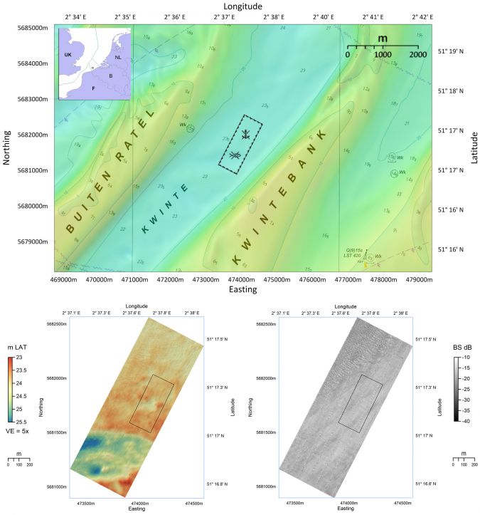
Extensive survey work over the KWINTE reference area has been carried out by Flemish Hydrography (VH) and Continental Shelf Service (COPCO) during the last decade, using multiple MBESs installed on different vessels with different setups and at different times. Multiple surveys allow depth and positioning measurements to be cross-checked, so that a reference model of the area can be built up. The seabed of the KWINTE reference area has been stable over a period of ten years regarding bathymetry and backscatter, showing neither significant accretion nor erosion trends. The KWINTE reference area has been included in the Marine Spatial Plan (MSP) 2020-2026 for the Belgian part of the North Sea as a reference area for underwater acoustic sensors. In practice, all seabed disturbing activities are prohibited inside this reference area, to preserve an undisturbed seabed for bathymetric and backscatter measurements in the long term. The MSP provides the following legal coordinates for the area.
What does the KWINTE area look like?
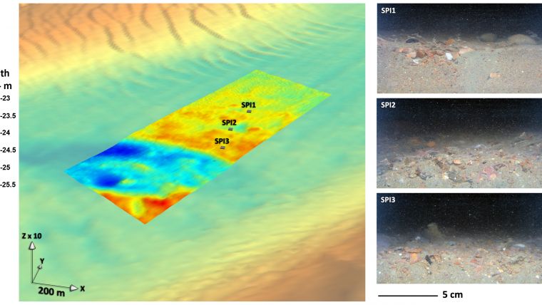
The KWINTE area is situated 17 kilometres from the Belgian coastline, in the trough between the KWINTE and Buiten Ratel sandbanks. The area is 1km long and 440m wide and is oriented at N60°. The water depth ranges from 23 to 26m LAT (Lowest Astronomical Tide). The area is mostly flat, with a slope in its southern part. The NW part is shaped by a network of small to medium dunes of 10–30m wavelength. No dunes are observed in the SE part of the larger KWINTE area, which is dominated by rounded and irregular hills and depressions of decimetric height, forming a typical hillocky morphology characteristic of the relatively flat gravel areas of the troughs between sandbanks. Tidal currents can reach up to 1m/s during periods of spring tides in the KWINTE channel and remain at around 0.5m/s during neap tides. Overall, the sedimentary cover of the KWINTE reference area consists of gravelly sand (gS) and sandy gravel (sG) with a high carbonate content that exceeds 15%, due to the abundance of shells.
Use as a bathymetric reference model
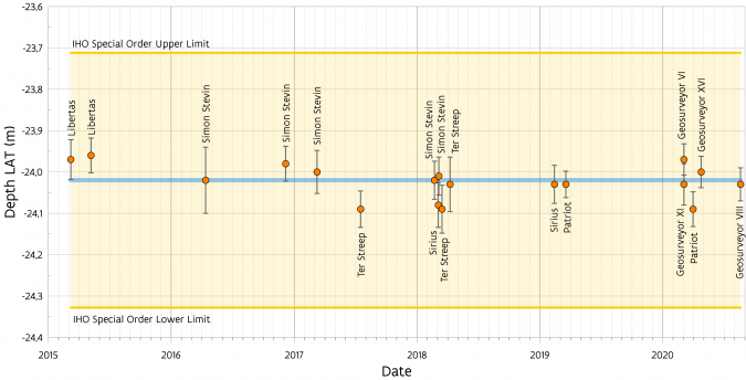
A bathymetric reference model was established inside a calculation sub-area of the KWINTE area based on the best bathymetric data collected by VH, COPCO and other parties. This reference bathymetric model makes it possible, by cross-checking, to assess the hydrographic quality of new bathymetric data collected by any MBES. In addition, due to the presence of slope and targets, the KWINTE area is suitable for an optimal patch test calibration (roll, pitch and heading). The mean reference bathymetric model is only constructed with surveys that use last-generation MBESs and Real Time Kinematic (RTK) online corrections, which gives the highest position and depth accuracy. Older surveys using tidal correction in the processing stage were omitted. Eighteen surveys have so far been approved, the various parameters calculated and the differences between each survey and the model determined.
VH uses the KWINTE reference area to assess the quality of the bathymetric data from the MBESs installed on the hydrographic vessels Ter Streep and Sirius (operated by DAB Vloot) and their multibeam set-up. Moreover, VH also uses the area as the final test for the Acceptation Tests that every contractor working for VH has to carry out before each new contract and before each MBES and vessel can be used.
By cross-checking the bathymetric data with the reference bathymetric model, COPCO assesses the bathymetric quality of the MBESs installed on the research vessels Belgica I (past) and Belgica II (future) (operated by the Belgian Navy and managed by BELSPO – KBIN OD Nature) and on the Simon Stevin (operated by DAB Vloot and managed by VLIZ).
Use as a backscatter reference model
Backscatter is used increasingly for habitat and sediment mapping and seabed change assessment linked to natural variations and human activities. Over the past three years, pragmatic solutions have been dispensed under the leadership of the Backscatter Working Group (BSWG) to ensure the absolute and relative calibration of the backscatter measured by MBESs. These solutions require a natural stable reference area or line, which serve to ensure three operations:
- Absolute calibration of the backscatter using a reference angular response model derived from backscatter measurements carried out with a single beam echosounder perfectly calibrated beforehand.
- Repeatability check of any MBES used as part of a monitoring programme by regular measurements of the reference area.
- The comparability of data from different MBESs based on measurements made by each of the systems on the reference area.
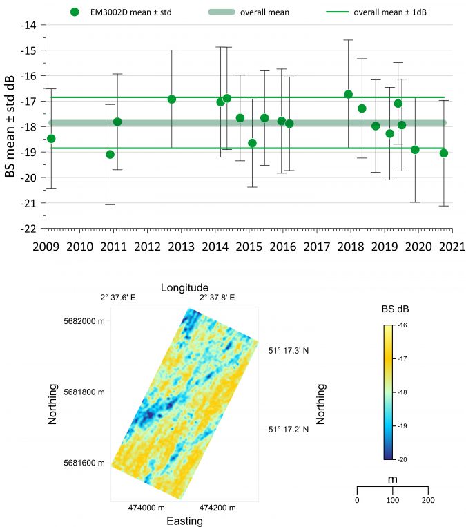
The stability of the KWINTE area over time is paramount to ensuring the consistency of this approach. Short- and medium-term low variability without trend has been demonstrated by backscatter time series from one MBES. In addition, the absence of accretion or erosion and the morphologic pattern of the KWINTE area demonstrate the stability of its sedimentary cover.
A backscatter reference model has been built by considering all the backscatter data from different surveys, collected in an incidence angular interval of 30°-50° with the same MBES. This model makes it possible to compare backscatter levels from different MBESs within the same incidence angular interval. The use of the KWINTE area for absolute calibration is under preparation, including the acquisition of data using a fully calibrated device.
For backscatter, the benefits of using a natural reference area are numerous. Establishing a network of calibration areas could greatly facilitate the calibration, quality control and merging of backscatter data from different MBESs used conjointly in national and international hydrographic and research programmes.
Get started
Please inform VH and COPCO if you undertake a new survey in the KWINTE reference area. The recommended procedure is described on the website, and it takes about two to three hours to survey the area. We ask that you acquire the data with online RTK for positioning and that you refer the data to LAT.
Once the survey has been carried out and processed, please send the complete project to VH and COPCO. All participants will receive feedback on their survey. The mean difference in depth over the small area should be no more than 20cm with reference to the model, which is stricter than the IHO Special Order norm. The delivered datasets will also be checked for artifacts resulting from timing, motion, sound velocity or other problems. If the bathymetric survey results are within the specifications of the IHO Special Order norm and none of the above described issues are revealed, the participant will be asked for approval to incorporate the results in the mean reference model calculation. If the participant agrees, information regarding the approved survey will be published on the website. Please note that an accepted survey over the KWINTE area does not guarantee that all subsequent surveys with the same vessel in other areas will also be accepted, as this is not the responsibility of the project partners.
Conclusion and acknowledgements
Extensive survey work over the KWINTE area reveals that its stable seabed is the perfect area for quality control of survey vessels with MBES. The area is defined in the MSP as an area where no seabed disturbing activities can be carried out. Both bathymetry and backscatter data can be checked and, if accepted, incorporated in a reference model. The area and model are open to use by every public or private institute or company that carries out multibeam measurements. All interested parties can use the model, and are encouraged to do so in cooperation with the project partners. All necessary information can be found on the project website.
The authors wish to thank their colleagues at VH and COPCO who participated in the project, as well as colleagues at the Royal Belgian Institute of Natural Sciences (RBINS) and Flanders Marine Institute (VLIZ). SPI was provided by the VLIZ. The authors also thank the crews of the hydrographic and research vessels involved in acquiring the data presented in this contribution.
More information and further reading:
- KWINTE reference area: https://www.afdelingkust.be/en/acoustic-reference-area-kwinte
- Belgian Marine Spatial Plan 2020-2026: https://www.health.belgium.be/en/environment/seas-oceans-and-antarctica/north-sea-and-oceans/marine-spatial-plan
- Eleftherakis, D., Berger, L., Le Bouffant, N., Pacault, A., Augustin, J.-M. & Lurton, X. (2018) Backscatter calibration of high-frequency multibeam echosounder using a reference single-beam system, on natural seafloor. Mar Geophys Res, 39, 55–73, doi:10.1007/s11001-018-9348-5
- Lurton, X. & Lamarche, G. (eds) (2015) Backscatter measurements by seafloor mapping sonars. Guidelines and recommendations. Geohab report. http://geoha b.org/publications/
- Montereale-Gavazzi, G., Roche, M., Degrendele, K., Lurton, X., Terseleer, N.; Baeye, M., Francken, F. & Van Lancker, V. (2019) Insights into the short-term tidal variability of multibeam backscatter from field experiments on different seafloor types. Geosciences, 9, 34, doi:10.3390/geosciences9010034
- Roche, M., Degrendele, K., Vrignaud, C., Loyer, S., Le Bas, T., Augustin, J.-M. & Lurton, X. &. (2018) Control of the repeatability of high frequency multibeam echosounder backscatter by using natural reference areas. Mar Geophys Res, 39, 89–104, doi:10.1007/s11001-018-9343-x
- Weber, T.C., Rice, G. & Smith, M. (2018) Toward a standard line for use in multibeam echo sounder calibration. Mar Geophys Res , 39, 75–87, doi:10.1007/s11001-017-9334-3

Value staying current with hydrography?
Stay on the map with our expertly curated newsletters.
We provide educational insights, industry updates, and inspiring stories from the world of hydrography to help you learn, grow, and navigate your field with confidence. Don't miss out - subscribe today and ensure you're always informed, educated, and inspired by the latest in hydrographic technology and research.
Choose your newsletter(s)


