S-121: A New Standard for Maritime Limits and Boundaries
The fundamental importance of maritime zones and other marine areas is underscored in the United Nations (UN) Sustainable Development Goal 14, which aims to conserve and sustainably use oceans, seas and marine resources. Maritime Limits and Boundaries (MLB) circumscribe and define these maritime and marine spaces, and incorporate the applicable Rights, Responsibilities and Restrictions (RRR). S-121, the widely anticipated marine data standard, provides a new open access method for providing and exchanging digital representations of MLBs.
Maritime Limits and Boundaries and Ocean Governance
Efficient and sustainable ocean governance requires, among other things, accessible high-quality data and information to support its decision-making functions. Central to governance is the control of behaviours within defined spaces, in relation to defined objectives, and according to accepted or imposed value systems. Good governance, therefore, requires information about resources, limits and boundaries, users and stakeholders, legal/regulatory/policy frameworks, and the relevant RRR that control behaviours.
Clarity in relation to limits and boundaries is a cornerstone of good governance. Barring deficiencies in enforcement, governance can break down at any fuzzy edges of governed spaces. Boundary uncertainties may generate governance uncertainties such as: What resources to exploit or manage? How to be in compliance? What to enforce? For the Maritime Domain, clarity at various scales and in relation to MLBs has long been the focus of international law of the sea. This is reflected in the 1982 United Nations Convention on the Law of the Sea (UNCLOS), other relevant international binding and non-binding instruments, as well as the laws, regulations and policies of coastal States.
The S-121 standard for MLBs aims to support the achievement of that clarity. According to the International Hydrographic Organization (IHO) (2018), S-121 will achieve this by: (i) providing coordinate-based spatial representations of MLBs that are accurate, reliable and easy to interpret; and (ii) facilitating States Parties’ obligations to UNCLOS, to deposit their outer limits of maritime zones, together with the lines of delimitations (maritime boundaries) with the Secretary-General of the UN, through the Division for Ocean Affairs and the Law of the Sea (DOALOS) of the Office of Legal Affairs of the United Nations.
Evolution of the S-121 Standard
A number of things have led to the development of the S-121 Standard for MLBs. These include: (i) UNCLOS requirements for States Parties to deposit charts and geographical coordinates representing their maritime zones, including lines of delimitation; (ii) the need to develop technical standards for the collection, storage and dissemination of the information deposited by States so that there is compatibility among various Geographic Information Systems (GIS), Electronic Nautical Charts (ENC), and other systems developed or used by them; (iii) a request by UN Member States to the Secretary-General to improve the existing GIS for the deposit of UNCLOS compliant charts and geographical coordinates, and to implement the developed technical standards in cooperation with relevant international organisations such as the IHO (A/RES/59/24, para. 6); (iv) a call by the General Assembly of the United Nations for Member States to implement international law as outlined by UNCLOS and thereby enhance conservation and sustainable use of oceans and marine resources. Based on the foregoing, DOALOS, as the designated unit, consulted with the IHO to identify an appropriate standard. This resulted in the formation of the S-121 project team that comprises participants from IHO Member States and the S-121 standard for MLBs (IHO, 2018).
S-121 aims to:
- Be simple, practical and implementable;
- Support accurate and precise descriptions of MLBs;
- Facilitate States’ communication of official digital representations of their MLBs;
- Respect the relevant provisions of UNCLOS;
- Provide a framework that is extensible by implementing parties to support other maritime delimitation requirements;
- Implement the IHO’s established S-100 framework as a product specification to ensure interoperability with other marine data specifications;
- Be interoperable and in compliance with relevant IHO (i.e, S-57 S-101) and International Organization for Standardization (ISO) standards (most notably ISO19152 Land Administration Domain Model (LADM)), thereby facilitating the construction of integrated cadastral systems;
- Support versioning, thereby facilitating monitoring and updating;
- Be linked to authoritative administrative source documents.
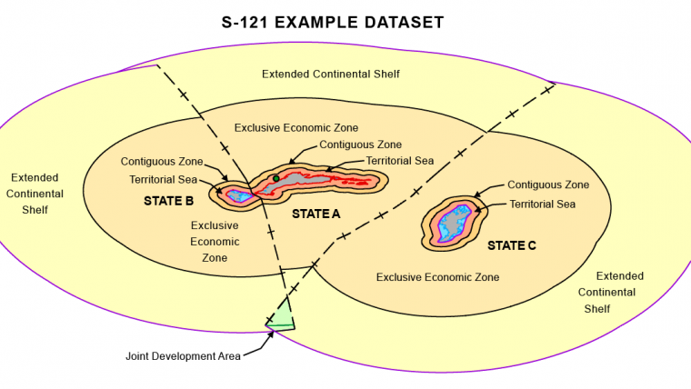
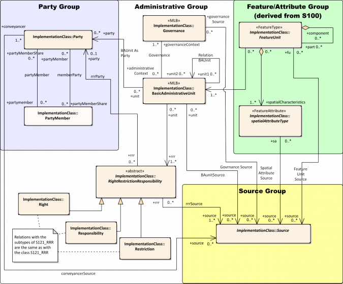
S-121 is designed to be used as a data model in the administration, management and maintenance of MLB information (Figure 1). The data model is simple and flexible, and is built upon IHO S-100 and ISO 19152 standards (Figure 2). It is also designed, in accordance with ISO TC211 standard, to facilitate data exchange in many different forms.
S-121 Benefits
S-121 is beneficial to data custodians, who can use the standard to maintain and exchange information on MLBs. Official versions can be created for distribution to stakeholders. The standard can also support legal proceedings, being able to produce output that is legally readable, targeted, and provides historical backtracking and source validation.
Apart from the obvious benefits to ocean governance through the management of MLB information, S-121 has implications for navigational safety, marine resources management, Marine Spatial Planning (MSP), Marine Cadastre (MC) and Marine Spatial Data Infrastructure (MSDI).
S-121’s ability to manage any MLB has direct benefits for navigation safety where correct identification of shipping lanes and other maritime limits are critical. This is enhanced by the standard’s facilitation of data exchange among stakeholders, and its interoperability with the future ENC standard, IHO S-101.
On the premise that the standard is commonly adopted, S-121 can contribute to improvements in MSP through increased/more effective data sharing among stakeholders and clarity offered in relation to RRR. MLBs form a fundamental building block for governance frameworks relating to marine resource management where they delimit spatial extents that are subject to management and protection schemes. S-121 is indispensable for MC and MSDI that require standard data models for MLB, data sharing capabilities, RRR clarity, interoperability, and versioning (among other things). Specifically in relation to MC, the literature has already established that ISO 19152 standard is applicable (Sutherland, Griffith-Charles and Davis 2016) and therefore S-121 is also applicable.
S-121 Receives Official Recognition
S-121 is the fastest evolving data standard. Its development was initiated by the General Assembly of the United Nations in its resolution 59/24. It has already received recognition from the ISO, the Open Geospatial Consortium (OGC), and the United Nations Global Geospatial Information Management (UN-GGIM). In the near future, a liaison project between the S-121 project team and the OGC will engage industry stakeholders regarding implementation and interoperability for wider use of the standard.
Conclusion
The marine domain has long been established to be of great importance to humanity. States exercise rights over maritime zones and other marine areas to meet their political, socioeconomic and environmental objectives. These objectives require, in part, clear delimitations of MLBs. Although S-121, built upon IHO S-100 and ISO 19152 standards, was initially developed to meet UNCLOS requirements, the standard is accurate and flexible enough to meet the needs of other marine/maritime governance frameworks and systems, including navigational safety, marine resources management, MSP, MC, and MSDI. It is one of the most eagerly anticipated data standards emerging from the IHO’s S-100 framework and has already received major recognition from key international stakeholders.
More Information/References
- International Hydrographic Organization (2018). www.s-121.com/w/index.php/Main_Page.
- Louis Maltais and Serge Lévesque (2018). S-121 Maritime Limits and Boundaries: Status report. Presented at the 10th IHO Hydrographic Services and Standards Committee, 14-17 May 2018, Rostock-Warnemünde, Germany.
- Sutherland, M., C. Griffith-Charles and D. Davis (2016). "Toward the Development of LADM-Based Marine Cadastres: Is LADM Applicable to Marine Cadastres?". Published in the proceedings of the 5th International Federation of Surveyors (FIG) Workshop on 3D-Cadastres, 18-20 October, Athens, Greece, 14 pages.

Value staying current with hydrography?
Stay on the map with our expertly curated newsletters.
We provide educational insights, industry updates, and inspiring stories from the world of hydrography to help you learn, grow, and navigate your field with confidence. Don't miss out - subscribe today and ensure you're always informed, educated, and inspired by the latest in hydrographic technology and research.
Choose your newsletter(s)


