Satellite Information to Increase Safety and Efficiency in Maritime Operations
A German consortium has developed a service providing detailed data on sea ice in polar regions where internet connections are slow, providing electronic navigational charts for poorly surveyed waters and software solutions to support maritime decision-making with satellite data. In July 2019, the partners completed the R&D stage of the MARSAT project, funded by the German Federal Ministry for Economic Affairs and Energy.
Smarter Routing in Higher Latitudes
“It’s not science fiction anymore,” said Dr Lasse Rabenstein, CEO of Drift+Noise Polar Services, a company specialising in the mapping of polar ice. “Fully automated, 24/7, near real-time ice image information for polar waters is available right now. Our support system for tactical decision-making includes an operational satellite image database; communication channels between ships, satellites and the internet; the automatic ship identification system (AIS) and the Ice Pad. The Ice Pad is a hardware device developed to transfer satellite imagery and ice data to ships, including areas where only a low-bandwidth Iridium connection exists.”
Efficiency and Safety in the Polar Region
Internet connections in polar regions use the Iridium satellite network, a costly solution with a bandwidth of only a few kb/s. Access to relevant data portals or even normal web pages is a challenge, if not impossible. Until now, this limitation has hampered the use of detailed ice information on board and the availability of high-quality ice information. “The Ice Pad is new to the community and a step towards greater efficiency and safety in the polar region,” said Frank Diegel, CEO of TRENZ, a maritime IT company. “For us it was the first time we had integrated near real-time satellite information into our software and hardware solutions, and we are proud of the interdisciplinary achievement of the team.”
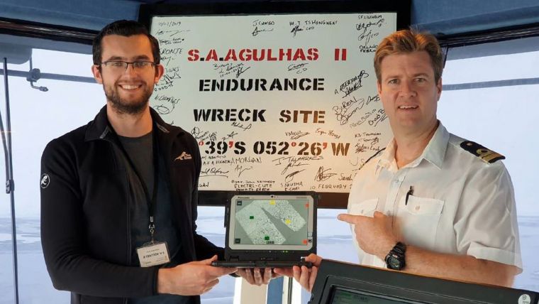
Lasse Rabenstein added “Amongst other things we have supported the Weddell Sea Expedition 2019 to Antarctica conducted by an international team of researchers on the South African research ice-breaker S.A. Agulhas II.
Updating Electronic Navigational Charts
“We had been aware of Satellite-derived Bathymetry for some time and were attracted by the simplicity of the approach,” said Friedhelm Moggert-Kägeler of SevenCs, a maritime software company. “Using satellite data to survey shallow waters brings so many advantages compared to labour- and equipment-intensive acoustic campaigns. We had questions about how this technology could be brought to the mariners, how it performs with S100 standards and where it brings the most benefits.”
Modern Satellite Capabilities
Satellite-derived Bathymetry (SDB) calculates water depth for shallow waters using sunlight reflected from the seafloor and recorded by satellite sensors. Although the technique has been investigated since the 1970s, it required modern satellite capabilities and advances in computing power to bring SDB to the broader community.
“We are finding a steady growth in uptake of Satellite-derived Bathymetry,” said Dr Knut Hartmann, Project Manager of MARSAT and COO of EOMAP. “Most applications are in planning and management of coastal zone environments and in engineering. Hydrographic applications have been less common so far, although some hydrographic offices are starting to systematically integrate SDB into their surveys. The MARSAT team has generated high-resolution and dense-contour electronic navigational charts (ENCs) complying with current standards. These charts are especially helpful to mariners in areas which are inadequately surveyed.”
“The demand from the maritime industry for up-to-date spatial information is obvious and much of the potential is yet to be explored,” said Dr Nils Meyer-Larsen, MARSAT Project Manager at the Institute of Shipping Economics and Logistics (ISL).

Value staying current with hydrography?
Stay on the map with our expertly curated newsletters.
We provide educational insights, industry updates, and inspiring stories from the world of hydrography to help you learn, grow, and navigate your field with confidence. Don't miss out - subscribe today and ensure you're always informed, educated, and inspired by the latest in hydrographic technology and research.
Choose your newsletter(s)


