Advanced Images Shed New Light on Titanic
Newly released images of the Titanic wreck site have provided the first unrestricted view of the maritime heritage site. These images supplement the collection of images published in the April 2012 issue of National Geographic magazine. For the first time, both the public and marine archaeologists can view the wreck as if the ocean were removed from the site.
The image mosaics are part of a collection containing over 200 optical mosaics created by the Advanced Imaging and Visualization Laboratory (AIVL) at the Woods Hole Oceanographic Institution (WHOI).
The AIVL, led by Bill Lange, used optical and sonar images collected during the expedition by a specially equipped remotely operated vehicle (ROV) and two autonomous underwater vehicles (AUVs), to stitch together the richly detailed, comprehensive views of the ship and wreck site.
The vehicles carried a combination of sonar used to make wide-area maps and advanced 3D camera systems used to conduct detailed forensic-type investigations. Although the individual robotic systems provided new information about some pieces of Titanic, the fusion of the imagery provides for the first time a comprehensive view of the wreck site.
In addition to AIVL, participants in the expedition included WHOI’s Ocean Systems Lab, led by Gregory Packard, which operated the two REMUS 6000 AUVs; archaeologists from the National Oceanographic and Atmospheric Administration (NOAA) and the National Park Service (NPS); and representatives from the Waitt Institute, owner of the two REMUS AUVs. WHOI Director of Special Projects David Gallo was co-expedition leader along with P.H. Nargeolet of RMST.
From the data collected at sea, the AIVL stitched together more than 250 individual mosaics to complete this comprehensive view of the ship and of the many thousands of objects in the surrounding wreck site.
The work contributes to an effort by NOAA and NPS, two U.S. governmental agencies developing a "site formation plan" to tell the story of how the ship broke apart and where pieces of the ship fell to the seafloor. It is part of RMST’s overarching effort to advance ongoing efforts to preserve the wreck site as a cultural heritage site.
In their first mission, the two REMUS AUVs used side-scan sonar to define the total extent of the Titanic wreck site in the context of the surrounding seafloor terrain. This initial survey area is approximately 3 by 5 nautical miles—an area about the same size as Manhattan Island, USA. This map was then used to define a tighter work area that focused specifically on the large pieces of Titanic (the bow and stern) and on the many thousands of artefacts that fell to the seafloor as the ship broke up and sank. The REMUS AUVs were then sent into this area, roughly equivalent in size to Midtown Manhattan, to make detailed down-looking maps that would be used to guide subsequent ROV operations.
A commercial ROV from Phoenix International was adapted reworking the power system, telemetry, lighting, cameras, and flotation system and turned it into probably one of the world’s best underwater, close-up, optical survey vehicles.
The Titanic wreck site now represents perhaps the best-surveyed part of the world’s deep ocean. Using digital data, views extend from surface data collected by a satellite to the detailed underwater data that can resolve a teacup or the filaments on a crab’s leg.
Aside from the public fascination with Titanic, the mapping and science is required in order to best understand how to manage the wreck site. By comparing the data collected in 1985 and 1986, for example, the 2010 images and data will help provide a detailed picture of the condition of the wreck and its rate of deterioration over time. In addition, scientists can study the marine animals that have made the ship’s hull their home to better understand how deep-sea ecosystems develop and evolve.
Many of the images including the map, are a direct output of "Titanic Expedition 2010." RMS Titanic will be adding both still images and interactive applications of the work done by WHOI to its touring exhibits, "Titanic: The Artifact Exhibition." A full list of cities where these mosaics and more exclusive content from the most recent expedition will be on display is available online.
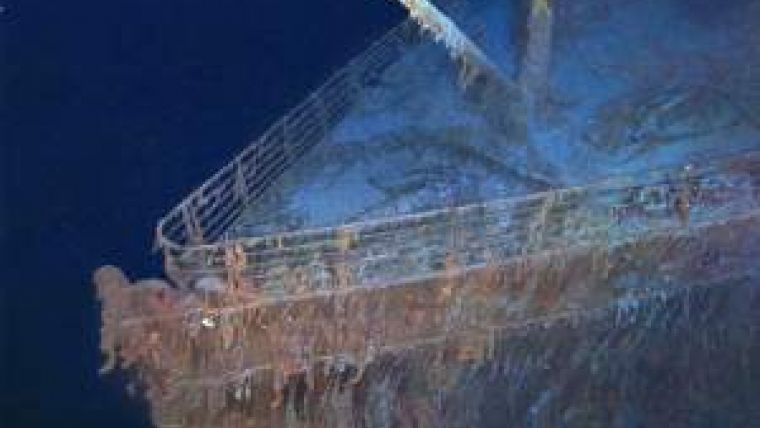
Image: This oblique view is comprised of hundreds of images that were stitched together. Post processing of the optical data was funded by Premier Exhibitions Inc. and the National Geographic Society. (copyright 2012 RMS Titanic, Inc. Produced by AIVL, WHOI).


