Airborne Hydrography Releases HawkEye III
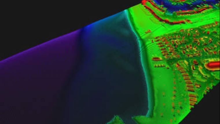
The HawkEye III airborne topographic and bathymetric Lidar scanner has been developed for territorial water and nautical charting surveys according to IHO S-44. The multi-sensor Lidar system includes a 10kHz bathymetric channel for high accuracy and high data density for deepwater; a 35kHz bathymetric channel is optimised for shallow water and the transition zone towards the shore. A 400kHz topographic channel provides resolution in data for demanding topographic jobs.
The HawkEye III captures the full waveform in all channels, deep bathy, shallow bathy and topographic. Optionally the system can also be combined with up to 80 MPIX RGB + Infrared camera Leica RDC 30 camera. HawkEye III delivers bathymetric Lidar data according to the International Hydrographic Organisation (IHO) S44 standard for nautical charts.
The system provides a full sea-floor search, i.e. 100% of the sea-floor is illuminated by the green laser beams. The system has no limitation of shallow depths, and delivers a total seamless dataset in the transition zone from sea-bed to land.
The HawkEye III system utilises the Lidar Survey Studio (“LSS”) software including proprietary tools and algorithms for waveform processing. LSS automatically measures the the local water surface level and compensates for the water refraction (difference between speed of light in water versus air). Bathymetric data is compensated both in elevation and in nothing easting. Further LSS automatically classifies the Lidar returns in the classes; land returns, water surface returns, sea-bed returns and intermediate water body returns.
HawkEye III utilises AHAB Oblique Lidar technology that illuminates objects from multiple angles, minimising shadowing in the data. Oblique Lidar is also superior for object detection - on land and in the water.


