Coastal and Port Risk Forecast and Warning Platform
HIDRALERTA
In Portugal, emergency situations caused by sea waves are common, and usually have serious consequences for the economy and society. It is thus crucial to implement an early warning system to forecast the occurrence of these situations in relation to wave overtopping and flooding events in coastal/port areas. The European Framework Directive 2007/60/EC of 23 October 2007 recommended the development of risk maps and flood risk management plans, including the establishment of systems for forecasting and early warning. The national and local authorities need to implement short-term/emergency measures to prevent the loss of lives and reduce economic and environmental damage.
The HIDRALERTA System
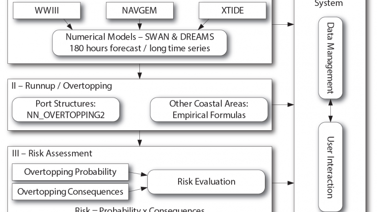
HIDRALERTA is a forecast and early warning system for coastal and port regions capable of predicting emergency situations, as well as carrying out risk assessment. The system concentrates on evaluating wave overtopping and flooding scenarios. It uses offshore sea wave and wind forecast data, as well as tide data, as input to determine wave overtopping at specific locations. This is done through the use of numerical models, artificial neural networks and empirical/semi-empirical formulas.
The values of the mean overtopping discharges per metre length of the overtopped structure are at a later stage compared with pre-established admissible maximums, enabling:
- Real-time evaluation of emergency situations and issue of warnings addressed to the relevant coastal/port authorities, whenever the safety and/or integrity of people, property or activities are at stake;
- Risk map production, considering long sea wave forecasting time series or pre-established scenarios associated with climate change and/or extreme events.
The HIDRALERTA system is composed of four modules developed in Open Source Web Technology, mainly using the Python Language. These modules are briefly described below (see Figure 1):
- Sea wave characterisation, obtains the sea wave conditions from numerical models for sea wave propagation;
- Wave overtopping determination, where, based on the wave characteristics and structure geometry, either an artificial neural network tool predicts mean wave overtopping discharges, or empirical formulas are used to evaluate wave run-up/overtopping;
- Risk assessment, defines a risk level for the predicted mean overtopping discharges;
- Warning system, integrates all the information and is responsible for early warning dissemination.
The Warning System (Figure 2) can be configured and adapted for specific scenarios and is made available via the Web. The design of the system considered the following adaptability conditions:
- Flexibility in evolving data sources: the system may need to generate results from different data sources, as availability conditions change;
- Automatic integration with the risk assessment component;
- Semi-automatic scenario generation and availability: each case study can be made available as a particular configuration;
- Dissemination strategy: Actors/stakeholders are profiled and the granularity of the configuration takes into account the hierarchical importance of the actor, as well as the region he/she represents (e.g. national, regional or local stakeholder).
The warning system persistently stores all data; mainly sensor data and risk assessment results. These data can be analysed in several media, using mapping or graphical support (Figures 3 and 4, respectively). Moreover, all emergency occurrences are logged and can be reviewed whenever required (Figure 3).
Case Study: Port of Praia da Vitória, Azores
The HIDRALERTA platform has been successfully tested for the Port and Bay of Praia da Vitória, Terceira Island, Azores, Portugal. The port is the second largest in terms of ships and goods movement and is located on the east coast of Terceira Island (Figure 5), one of the nine islands of the Azores Archipelago. The protection of the bay is supported by the northern breakwater, built to protect the port facilities of the Lajes airbase, and the southern breakwater, intended to protect the commercial sector and fishing port facilities. A marina was built at the location of the former fishing harbour taking advantage of the shelter provided by these breakwaters. The port basin is approximately 1km by 2km.
Given the forecast complexity of some of the phenomena studied in the HIDRALERTA project and the requirement to calibrate the numerical models, a validation tool was developed and integrated into the platform. This tool enabled the visualisation and comparison of data measured by the Praia da Vitória buoy with the HIDRALERTA forecast for the same location. Furthermore, the tool allows the comparison of historical data through a dynamic graph (Figure 6).
The system was tested during the winter of 2015/16. During this period, the HIDRALERTA team monitored the North Atlantic Sea and analysed the system’s response in terms of wave forecasting, wave propagation to Terceira Island, wave adaptation to shallow waters and wave propagation to the bay, and finally, wave overtopping occurrences. Each 24-hour period the system automatically generated a new 24-hour forecast as well as a 72-hour forecast.
Conclusion
The HIDRALERTA team was able to provide effective support to local authorities during the passage of Hurricane Alex in the Azores on 15 January 2016 (Figure 7). The daily reports sent to the authorities in Praia da Vitória enabled the following:
- To predict the possible occurrence of storms with overtopping potential 72 hours in advance;
- To identify computational system problems which could delay or invalidate forecasting;
- To validate the system in terms of overtopping occurrence and magnitude through the feedback given by local authorities;
- To develop communication channels and to establish an active bridge between science, government and society.
HIDRALERTA identified the low pressure system that originated the hurricane as early as 7 January. The system is now also being deployed on the beach of S. João da Caparica, in Costa da Caparica (south Lisbon area), also in Portugal.
More Information
- Sabino, A., Rodrigues, A., Poseiro, P., Reis, M.T., Fortes, C.J., Reis, R., 2015. Coastal Risk Forecast System, First International Conference on Geographical Information Systems Theory, Applications and Management, Barcelona, Spain, April.
- Sabino, A., Rodrigues. A., Araújo, J., Poseiro, P., Reis, M.T., Fortes, C.J., 2014. Wave Overtopping Analysis and Early Warning Forecast System. Computational Science and Its Applications - ICCSA 2014 - 14th International Conference, Guimarães, Portugal, June 30 - July 3.
- Fortes, C.J.E.M., Reis, M.T., Poseiro, P., Capitão, R., Santos, J.A., Pinheiro L.V., Craveiro J., Rodrigues, A., Sabino, A., Silva, S.F., Ferreira, J.C., Raposeiro, P.D., Silva, C., Rodrigues, M.C., Simões, A., Azevedo, E.B., Reis F., 2014. HIDRALERTA Project – A Flood Forecast and Alert System in Coastal and Port Areas. Proc. IWA World Water Congress & Exhibition, Lisbon, 21-26 September.
- Reis, M.T., Silva, L.G., Neves, M.G., Lemos, R., Capitão, R., Fortes, C.J.E.M., Poseiro, P., 2015. Tools for forecasting and evaluation of structural risk on maritime works. PIANC Yearbook 2014. Technical Articles provided by the Portuguese Section of PIANC, Host Country of the AGA 2015. April, pp. 146-158.
- Poseiro, P., Fortes, C., Reis, M.T., Santos, J.A., Reis, R.A., 2015. Applications of the forecast and alert system for wave overtopping in coastal and port areas: Costa da Caparica e Praia da Vitória. Revista de Engenharia e Tecnologia, Vol. 7(2), June Especial Edition. (in Portuguese)
Acknowledgements
The authors acknowledge the financial support of the research projects HIDRALERTA (PTDC/AAC-AMB/120702/2010) and M&M Ships (PTDC/EMSTRA/5628/2014), funded by the Portuguese Foundation for Science and Technology (FCT). Pedro Poseiro PhD studies are also supported by FCT, research grant SFRH/BD/97193/2013.

Value staying current with hydrography?
Stay on the map with our expertly curated newsletters.
We provide educational insights, industry updates, and inspiring stories from the world of hydrography to help you learn, grow, and navigate your field with confidence. Don't miss out - subscribe today and ensure you're always informed, educated, and inspired by the latest in hydrographic technology and research.
Choose your newsletter(s)


