Dutch Flood Defence, the Natural Way
When the Dutch government and research institutions wanted to monitor how waves and currents would affect the pioneering use of artificial sand banks to protect a levee in a non-tidal freshwater system, Nortek was selected to supply key measuring instruments and set up the data telemetry system.
The Houtribdijk is a 25km-long levee, or dike, separating two large artificial lakes, the IJsselmeer and the Markermeer. The lakes and accompanying levees protect the Netherlands from the forces of the North Sea’s extreme weather events, and from flooding from inland freshwater river systems.
After years of exposure to the elements, the Houtribdijk was in need of major maintenance. The traditional way of making it more secure would have been to bolster the barrier of rocks and other building materials that already protect the levee from the impact of water during storms. But this time, the authorities decided to try something different.
A Nature-based Solution for a Protective Barrier
The authorities decided to opt for a more nature-based solution: the creation of two 140m-wide artificial beaches on either side of the levee, whose sloping contours would improve the protection from waves and the elements. In addition, these beaches would create an attractive and valuable natural habitat for coastal flora and fauna, as well as a new zone for recreational activities.
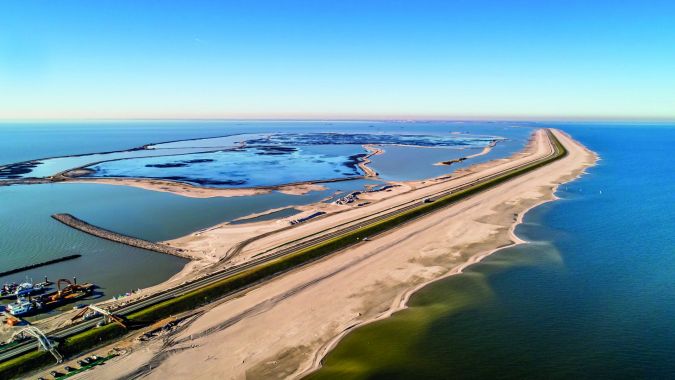
Some 10 million m³ of sand needed to be deposited around the levee – that’s as much sand as is used to maintain the entire seashore of the Netherlands from erosion in a year. After the reinforcement, the levee should be able to withstand storms with an intensity only likely to occur once in every 10,000 years.
A Pioneering Project
The project is also a world first because, while such sand-based reinforcement has previously been carried out in coastal defences against seawater, it has never been used in non-tidal freshwater conditions.
A test area was created in advance, and specialists from the EcoShape knowledge consortium used it to conduct extensive research on how the sand behaves. This knowledge led to the full-scale application of the solution.
Henk Meuldijk, reinforcement project manager at Rijkswaterstaat, reports: “It is really good that measurements were taken at the pilot site for a number of years. We can see that the shape of the sand mass is relatively stable after two years. We have used this knowledge for the construction of the reinforcement as well as for our management and maintenance plan.”
Rijkswaterstaat is part of the Dutch Ministry of Infrastructure and Water Management, and is responsible for the design, construction, management and maintenance of the main infrastructure facilities in the Netherlands.
Meuldijk hopes to deepen the knowledge gained about the reinforcement of the Houtribdijk by means of the research and monitoring programme now applied on the full, large-scale solution, which is no longer a small-scale pilot site. The current research and monitoring programme on the full-scale solution is being led by Rijkswaterstaat in collaboration with Delft University of Technology.
“The knowledge that we are gaining here will be very useful in the Netherlands and beyond,” Meuldijk says.
The Importance of On-site ADCP Monitoring
The extent to which desktop modelling can help on such a pioneering project is limited, given the multiple forces at work and the complexities of the feedback between them. If the sand starts shifting on test sections of the beach or holes start appearing in it, then the researchers need to know exactly what forces are at play.
That means detailed monitoring of the interaction between the water and the sand, to ensure that the defences are fit for purpose – and this is where Nortek was able to help.
“With traditional coastal protection works, you only deal with physical problems, such as currents, waves and rock forces. But with these nature-based solutions, you need a much greater degree of monitoring, because the outcomes are much harder to predict and you need to take into account ecological elements like flora and fauna,” explains Sicco Kamminga, managing director at Nortek’s subsidiary in the Netherlands.
Current Meters and Current Profilers for Precision Monitoring
Nortek provided Vector current meters and Aquadopp current profilers, the latter operating in high-resolution mode for higher-precision measurements.
“Nortek was selected by means of a public tender procedure by the Dutch authorities, and was finally chosen because it offered the best quality for an acceptable price. Nortek suggested various additional elements of the total set-up that led to a more robust and reliable monitoring system,” says Rinse Wilmink, project manager and advisor on coastal flood risk management and morphology at Rijkswaterstaat.
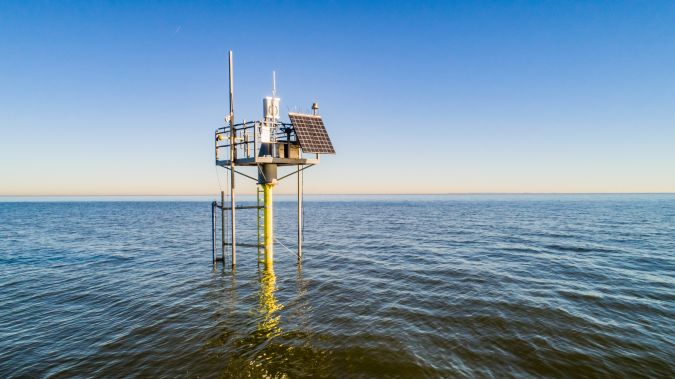
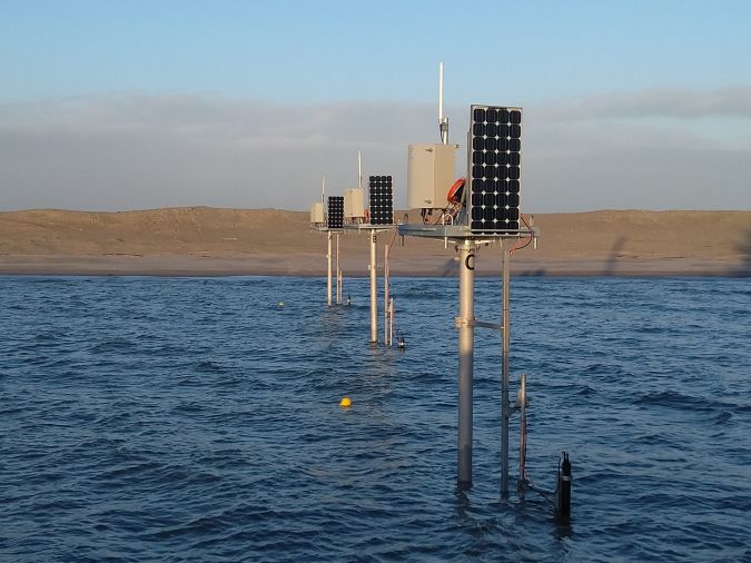
Not only was accuracy vital, but energy consumption needed to be low, as the instrument arrays were mounted on small platforms in shallow water powered only by small solar panels.
“Low energy consumption was a key requirement, and our instruments consume very little power, even when working continuously,” says Rikke van der Grinten, sales engineer at Nortek.
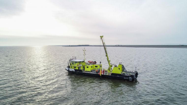
Nortek was also tasked with devising the telemetry system for data transfer from the instruments. Establishing the capability to reliably transfer and present up to 1GB of data a day was challenging, both technologically and in terms of the time available.
Firstly, Nortek’s engineers needed to get the job done in just two months, including the Christmas of 2018. Then, the client also required the firm to work with diverse instruments from multiple manufacturers, integrating all of these into one functioning system.
“Carrying out a project of this complexity in such a short timeframe was a big challenge, but two months after we took on the work, the systems were operational,” says van der Grinten.
Using ADCPs for Efficient Maintenance of the Dike
The monitoring programme is helping to determine how to maintain the dike more efficiently, and the extent to which the sand banks will need to be maintained in the coming years. The dike reinforcements – a mixture of the sand banks, stone and asphalt – are expected to be completed in early 2020.
They are expected to function well for ten years without much maintenance once completed. However, no one is sure how much, if any, further reinforcement will be needed beyond that time. The detailed data now being collected will give a much clearer idea of what’s needed.
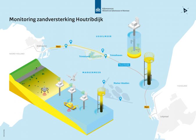
The flood protection system on the Houtribdijk levee is being monitored in various ways:
Morphodynamics: Over time, the sand will form an equilibrium with the incoming wave action. Various measurements will teach us which important processes are driving the deformation of the sand. ADCPs measure currents and waves and small-scale turbulence at these stations.
Circulating installations: Three locations are being monitored in detail where high-frequency waves, velocity and morphodynamic measurements are performed. These locations change over time during the programme. Here, Nortek’s Vector current meter measures high-frequency currents in a small measurement volume, and the Aquadopp Profiler measures short-term variations in current profiles close to the bed.
Long-term benchmarks: These benchmark installations will be active throughout the programme. The installations measure offshore wave and velocity conditions in the Markermeer and IJsselmeer. ADCPs also measure currents in these stations.