
EMODnet Bathymetry Now Offers Highest Resolved Bathymetric Worldwide Layout
Bathymetry, the topography of the seafloor, is a fundamental feature of the ocean. Accurate bathymetric data is the foundation for much of ocean science and policy. For example, nautical charts are based on these data to ensure safe ship navigation and bathymetric maps allow scientists to develop more accurate models to investigate the effects of climate change on the environment.
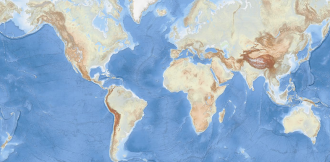
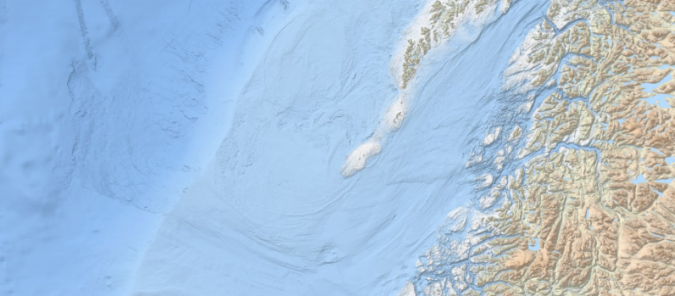
EMODnet’s new World Base Layer Service (EBWBL) provides fast and easy access to worldwide bathymetric information, enabling marine knowledge users including industry, scientists, coastal managers, students and the general public to access high-resolution representations of seabed features from their own computer. EBWBL provides the highest resolved topographic and bathymetric worldwide layout currently available with land and sea integration matching the OpenStreetMap coastline representation.
This new service is freely accessible from the EMODnet Bathymetry portal, for integrating into your favourite application, along with guidance documentation and a demo viewer to zoom in on every detail. It is available in various projections, such as non-projected coordinate system, Web Mercator, Inspire compliant projection and projections adapted to both poles.
“The new EMODnet Bathymetry World Base Layer Service is a real breakthrough in the provision of open-access global ocean information for all types of users; from industry to the general public, and from scientists to marine spatial planners. It highlights EMODnet’s contribution and leading role in the global ocean observation landscape”, said Iain Shepherd, senior policy officer, EC DG MARE.
Pre-rendered Images
This first edition of the EBWBL has a global coverage and combines the General Bathymetric Chart of the Oceans (GEBCO) gridded data and the EMODnet Bathymetry Digital Terrain Model (EMODnet DTM) at the highest resolution as a Web Map Tiles Services (WMTS).
WMTS displays pre-rendered images from a web server, which means it is less computationally demanding and faster than rendering images in the browser, a benefit over technologies such as WFS.
EBWBL provides access to the pre-rendered tiles of the most reliable and publicly available bathymetric dataset. The service is planned to be maintained and updated on a regular basis. It includes bathymetric data on all lakes worldwide, with a 30m resolution. Lakes are nicely blended in with the landscape. The colour scheme is specifically chosen to display enough details in the different depth ranges. On land, the same fine details can also be discovered.
Technical Background Information
Based on a modern WMTS schema, a standard protocol (OGC) for serving pre-rendered georeferenced map tiles over the internet, the EBWBL is composed of the 2018 EMODnet bathymetric grid of Europe (approx. 100m resolution) and uses the GEBCO 2019 grid (approx. 500m resolution) elsewhere. The land coverage is based on a combination of 30 arc second ASTER GDEM, SRTM3, EU-DEM and Global 1 second worldwide waterbody maps for the topographic part. This compilation of publicly available data sources has been merged and pre-tiled for rendering, at ten levels of magnification starting from 75m resolution. The EBWBL service is available in various projection systems (EPSG 4326, EPSG 3857, EPSG 3035) including projections adapted to both poles (ESPG 3031 and 3996).


