GIS Software for Underwater Survey
Utilising full-motion video (FMV) technology, CSA Ocean Sciences Inc. (CSA) marine biologists have successfully conducted an underwater biodiversity survey. FMV is defined as digital video with integrated geospatial information (real-time latitude and longitude) and relates the video to other geospatially defined attributes, such as multibeam bathymetry, in space and time.
Unlike older technologies where static time and latitude and longitude were ‘burned’ into the digital image, the spatial and temporal information associated with FMV can be accessed by geographic information systems (GIS). The result is a powerful tool for capturing geospatially articulated information from within the video image and rendering that information into a GIS for further analysis.
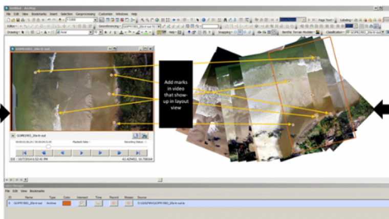
During this survey, CSA assessed fish and macro-invertebrate assemblage composition and abundance over reefs and other hard bottom features. Digital video and navigation data were collected from an underwater vehicle that was used to survey transects over a target area. As data were collected, they were fused into a FMV stream and then recorded as FMV-compliant video. The FMV was then played back in association with a seafloor map in ArcGIS for Desktop.
The process of synchronisation (in live stream or post-processing mode) can be conducted using any combination of vehicles, vessels, or even divers carrying a camera using CSA’s underwater telemetry systems. As the FMV is played back, pre-determined bookmarks representing transects, quadrats, or other sample units are integrated with the video to provide a more complete, geographically accurate time track of the camera over the seascape as a cross-check to ensure that proper sample boundaries were maintained. In addition, ArcGIS for Desktop allows the analyst to classify and record the position of objects in the video (fish and macroinvertebrate species) from pre-prepared drop-down menus. This makes for a more highly efficient workflow, obviating the need to constantly record observations on electronic or paper data sheets—instead, observed attributes within the video instantly become part of the database. With survey designs that employ line transect or distance methods, FMV video analysis allows distances and angle from the line transect to be calculated. Full motion video also facilitates frame grabbing and compilation of selected or time interval frames into mosaics that can be used for fish habitat analyses.
Once the biological data were extracted for this project, advanced GIS techniques were employed to determine spatial associations of the biota with seafloor features, helping to identify potential hotspots of biodiversity and essential fish habitat.


