IHO Encourages Crowdsourced Bathymetry
At the 5th Extraordinary International Hydrographic Conference, held in Monaco in October 2014, the International Hydrographic Organization (IHO) agreed on the need to explore sources of bathymetric data outside traditional observations – particularly in support of defining a baseline global bathymetric dataset for the many non-navigational uses for depth data that are now emerging. This resulted in the establishment of a Crowdsourced Bathymetry Working Group that was tasked to provide guidance on how the IHO could encourage and promote crowdsourcing by vessels and craft using standard, fitted equipment.
The IHO has a long history of encouraging the collection of crowdsourced bathymetry. The General Bathymetric Chart of the Oceans (GEBCO) project was initiated in 1903 by Prince Albert I of Monaco to provide the most authoritative, publicly-available bathymetry of the world's oceans. Over the years, the GEBCO project, now jointly overseen by the IHO and the Intergovernmental Oceanographic Commission of UNESCO, has obtained depth measurements collected by vessels as they journeyed across the oceans. These ‘passage soundings’ have enabled the creation of progressively more-detailed seafloor maps and digital data grids. More recently, systematic surveys have also been used to improve these maps and grids.
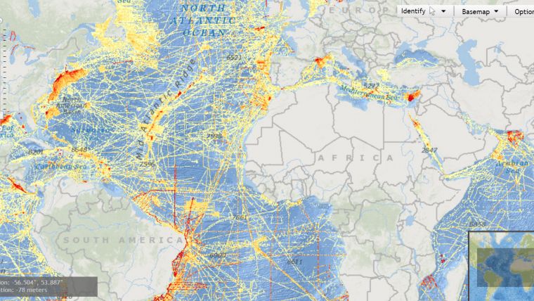
Unfortunately, notwithstanding the efforts in collecting data since 1903, less than fifteen percent of the world’s ocean depths have been directly measured; the rest of the data used to compile the maps of the seafloor are estimated. These estimates are largely derived from satellite gravity measurements, which can miss significant features and provide only coarse-resolution depictions of the largest seamounts, ridges and submarine canyons. Progress in mapping the world’s coastal waters is only marginally better. IHO figures indicate that about fifty percent of the world’s coastal waters less than 200m deep remain unsurveyed.
While the hydrographic and scientific community lament this lack of real data, the world’s interest in seas, oceans and waterways continues to increase. The concept of a ‘blue economy’ is firmly established, along with an ever-growing public awareness of mankind’s dependence upon, and vulnerability to the sea. Several high-level global initiatives are now in place that seek to address ocean issues, including the goals associated with the United Nations 2030 Agenda for Sustainable Development, the Paris Agreement under the United Nations Framework Convention on Climate Change, and the Sendai Framework for Disaster Risk Reduction 2015-2030.
International shipping regulations oblige all commercial vessels to be equipped with certified echo sounders and satellite-based navigation systems. As a result, the world’s commercial fleet represents a significant, and as yet largely untapped, source of potential depth measurements. While crowdsourced data may not meet the accuracy requirements for charting areas of critical under-keel clearance, it still holds significant potential for other uses. If vessels collect and contribute depth information while on passage, their data can be used to help identify uncharted features, to assist in verifying charted information, and help to confirm that existing charts are appropriate for the latest traffic patterns. Crowdsourced bathymetry can also provide vital information to support national and regional development activities, and scientific studies in areas where little or no other data exists. Crowdsourcing can be a valuable and efficient way to determine where rigorous hydrographic surveys need to take place.
The IHO Crowdsourced Bathymetry Working Group, comprising representatives from national Hydrographic Offices, academia, and industry has developed the first draft of a guidance document that sets out the key issues regarding crowdsourcing - both from a collector’s and a user’s perspective. The guidance document is intended to provide general advice and information for those considering collecting or using crowdsourced bathymetry. It is not intended to be either prescriptive or authoritative, but rather to alert those with an interest in crowdsourcing of the relevant considerations to take into account. The draft guidance document on crowdsourced bathymetry is now available on the IHO website at: https://www.iho.int/srv1/index.php?option=com_content&view=article&id=635&Itemid=988&lang=en. The IHO Crowdsourced Bathymetry Working Group would welcome comments and feedback on this first draft, which can be forwarded to the chair of the working group at: [email protected].

Value staying current with hydrography?
Stay on the map with our expertly curated newsletters.
We provide educational insights, industry updates, and inspiring stories from the world of hydrography to help you learn, grow, and navigate your field with confidence. Don't miss out - subscribe today and ensure you're always informed, educated, and inspired by the latest in hydrographic technology and research.
Choose your newsletter(s)


