Improving Satellite-derived Bathymetry
Using Spatial Regression Algorithms
Bathymetry is traditionally acquired using singlebeam or multibeam echosounders. This method produces accurate depth measurements along transects but is constrained by operating cost and an inability to survey in very shallow waters. Airborne Lidar is able to produce accurate bathymetric information over clear waters at depths up to 70m, but can be costly and is limited by a relatively coarse bathymetric sampling interval. Experience in Irish waters has resulted in very poor seabed detection along the east coast and limited penetration on the west coast. An efficient and cost-effective alternative is satellite-derived bathymetry.
Calculating Depths by Satellite
Satellite Derived Bathymetry (SDB), which has been used since the 1970s, can be implemented through either analytical or empirical methods. Empirical methods explore the statistical relationships between image pixel values and field measured water depths. Analytical approaches rely on the general principle that sea water transmittances at near-visible wavelengths are functions of a general optical equation dependent on the intrinsic optical properties of sea water. A number of external factors affect the accuracy of the depth calculation, including the spatial and spectral resolution of the imagery, the viewing angle of the satellite, the solar illumination angle, atmospheric effects, sunlight, tide level and submerged vegetation. Careful selection of satellite imagery and subsequent image processing can mitigate some of these effects.
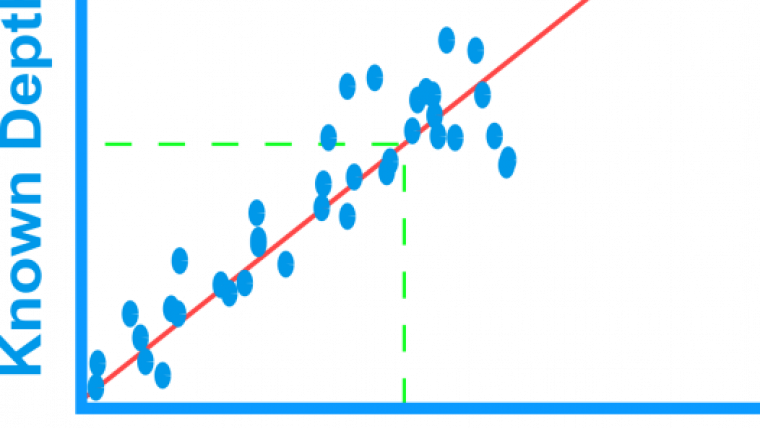
A 2013 pilot study in Dublin Bay using SPOT satellite data indicated strong potential for bathymetric mapping in coastal environments using geographically weighted regression (GWR) in conjunction with remotely sensed data. GWR is a branch of spatial analysis which has previously demonstrated its usefulness in modelling complex spatial patterns and phenomena. Bathymetry has a strong spatial component, i.e. a measurement depends in part on where it was taken. So instead of using a global model such as Ordinary Least Squares (Figure 1) to fit predictions, a local, spatial regression algorithm is better suited.
GWR enables a local model of the variable that we are trying to predict (in this case depth) by fitting a regression equation at every location in the dataset. Unlike the ‘global’ regression model which gives equal weight to every observation, GWR gives more weight to those observations near the current regression point than those further away. (Figure 2).
Research Goal
Building on established image processing methodologies for calculating satellite derived relative depths, the National Centre for Geocomputation, TechWorks Marine Ltd. and the Geological Survey of Ireland are exploring the benefits of local rather than global models, improving accuracy when calculating water depth and subsequently decreasing prediction errors in deep or turbid waters.
Our goal in this study was to develop a methodology to improve the prediction accuracy using an empirical approach and geospatial modelling. Results were validated with INFOMAR (Irish National Seabed Mapping Programme) multibeam depth data with an estimated accuracy 0.2% of actual water depth at 0m to 50m.
Testing in Irish Waters
Four of the INFOMAR priority bays were explored in turn: Blacksod Bay in Co. Mayo, Dublin Bay at the mouth of the River Liffey, Tralee Bay in Co. Kerry and Mulroy Bay in Co. Donegal. The four test sites represented very different coastal environments - Dublin and Tralee are affected by significant river deposits. Additionally, Dublin Bay opens onto the Irish Sea and large amounts of sediment wash up the East coast of Leinster and into the bay (Figure 3).
Figure 4 displays the INFOMAR bathymetric map of Mulroy Bay created using airborne bathymetric Lidar. One of the key aims of the study was to assess the suitability of imagery captured at a range of spatial, spectral and temporal resolutions. A selection of imagery such as Rapideye, SPOT and Pleiades was provided by the European Space Agency imagery and when combined with existing Landsat 5, 7 and 8 imagery this enabled the application of a range of band combinations, solar illumination angles, temporal, spatial and spectral resolutions.
Test Results
The initial tests in Mulroy Bay using Landsat 8 and RapidEye imagery proved very promising due to water clarity, quality of the images and penetration range. After image corrections and initial processing, Satellite Derived Relative Depths (SDRD) were calculated using existing bathymetric band log ratio algorithms.
The correlation between SDRD and true depth for three image datasets is displayed in Figure 5. The RapidEye (5m x 5m spatial resolution) images for Mulroy Bay were better suited for calculating bathymetry at depths of 10m+, however, the coastal/aerosol band on Landsat 8 (30m x 30m) resulted in a steeper correlation gradient, indicating better potential for discriminating changes in water depths in the 0-10m range.
The SDRD values were spatially joined (Figure 6) to the nearest Lidar/SONAR depth (max distance = image spatial resolution). The new grid dataset containing both fields of information were then reduced (only 0.005% of data required) for calibration purposes. Predictions were performed in the rest of the bay independently of the calibration data, relying solely on the SDRD and the local model. These tests were carried out using a variety of grid patterns and the initial tests demonstrated accuracies of +/- 1m across the bay even in water depths up to 20m. Performance was good at the narrow channel entering the south of the bay (Figure 7) and importantly, even near the partially submerged rocks in the centre of the bay, Bar Rocks and High Rock. Larger errors were encountered near the submerged kelp in the north east of the bay but this had also proved problematic and noted in the report from the airborne bathymetric Lidar surveys.
Subsequent tests after the research mentioned have incorporated other geospatial algorithms and included seabed type and backscatter data as additional predictor variables. TechWorks Marine have developed a network of sensor buoys that can also provide information on turbidity and this is being incorporated in the later stages of the methodology.
Conclusion and Further Research
The Mulroy tests were able to clearly demonstrate that the spatial model showed better adjustments than the traditional non-spatial model in the water depth predictions for turbid regions using the same image processing workflow. Furthermore, spatial regression algorithms have the potential to significantly improve the prediction accuracy of SDB in coastal waters and its quality assessment.
Additional funding has been provided by the GSI to assess the application of very high-resolution imagery captured by light aircraft and unmanned aerial vehicles (UAVs). The proven benefit of a multi-resolution imagery approach will also be extended to include imagery from Sentinel 2a.
Acknowledgements
This research was conducted with the financial support of Science Foundation Ireland under Grant "SFI 13/IF/I2778” and the Geological Survey of Ireland-Infomar Short Call, 2015. The authors wish to acknowledge the European Space Agency for providing RapidEye datasets under Blackbridge Ltd copyright and INFOMAR for facilitating data access and expert advice.
More Information
- INFOMAR: The INtegrated Mapping FOr the Sustainable Development of Ireland's MArine Resource; www.infomar.ie .

Value staying current with hydrography?
Stay on the map with our expertly curated newsletters.
We provide educational insights, industry updates, and inspiring stories from the world of hydrography to help you learn, grow, and navigate your field with confidence. Don't miss out - subscribe today and ensure you're always informed, educated, and inspired by the latest in hydrographic technology and research.
Choose your newsletter(s)


