Learning Curve during Survey in Antarctica
Colombia’s First Scientific Expedition to Antarctica
The first Colombian scientific expedition to Antarctica was a major challenge for the country and the Colombian Hydrographic Survey organisation because of the extreme conditions in which the investigations had to be carried out. It is Colombia’s vision to contribute to the preservation of the 'White Continent'. The preparation and the professionalism of the scientists and crew were critical to achieving the objective of the cruise: to become part of the Antarctic Treaty. This objective has been set out to the member countries of the ’Antarctic Treaty’ in Document 104.
Within the Antarctic Treaty Colombia intends to change its status, from an observer country to a consultative treaty country. This resulted in the preparation of the first Colombian expedition to Antarctica.
During the preparatory meetings of the expedition, we listened and took note of the recommendations made by the Hydrographic Services of Ecuador, the Hydrographic Service of Chile and the Chilean Antarctic Institute INACH, institutions with extensive experience in research in these latitudes. Each meeting and each recommendation increased our anxiety and fears to explore the unknown, but at the same time, we were encouraged to ultimately prepare ourselves for this challenge.
The hydrographic research was coordinated by the Chilean Hydrographic Service and was to result in the delivery of bathymetric information in four areas in the Gerlache Strait, specifically to the nautical chart INT 9103 SHOA / CHILE Bay Markmann to Andrvord Bay.
Only 10% of the Antarctic waters are mapped, so this hydrographic survey will be an important contribution to the maritime security in this region, which can be used by all countries practicing tourism or conducting research in this area.
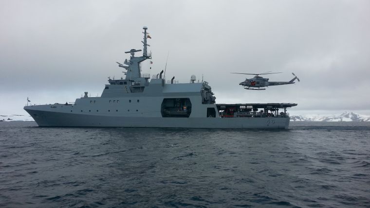
The Colombian Navy originally commissioned the oceanographic research vessel ARC Malpelo to carry out this cruise. However, after several meetings and recommendations from countries with experience in operating in Antarctic waters, it was decided to commission the EEZ patrol boat ARC 20 de Julio as the platform for research. The vessel was built in the shipyards of COTECMAR in Cartagena, Colombia, and is one of the largest and most modern units built in our country and gave more prominence to the project. Now a vessel, built in Colombia, was to be used with 107 Colombians doing research in the white continent.
This pride also became a great challenge for the crew and scientists, since the patrol ship initially did not have the capabilities to fulfil the mission, so that a search for solutions began to adapt the vessel for this purpose.
First Challenge: Hydrographic Survey in Deep Waters
The research centre CIOH proposed the installation of a single beam echo sounder for deepwater using a dual frequency. With the strong support of the Colombian Navy and the capabilities of our shipyard, the installation could be executed in less than a month.
The dual frequency single beam echo sounder, a Kongsberg EA600, was installed on board the ARC 20 de Julio.
Second Challenge: Sound Velocity Profile Collection Data
A mobile oceanographic winch platform (MPO) was built to collect the data of different oceanographic devices, such as a SVP, a multi bottle rosette sampler, a bottom grab or a piston corer. The initial design was made by the Hydrographic service and the system was built by an engineering firm.
Using this system, we were able to collect 17 sound velocity profiles geographically distributed in the study area, resulting in an average sound velocity of 1,446 m/s.
Third Challenge: Hydrographic Survey in Shallow Waters
For surveying in shallow waters it was necessary to adapt the intervention boat (built as a unit for the Colombian coast guard) into a hydrographic boat. It had the basic features to operate in this harsh environment, with a heated cabin, for instance.
A portable dual frequency echo sounder was adapted, with the transducer installed on one side and the GPS antenna installed on the top post, in order to gain accuracy in the measurement and to reduce any ‘off set’ events.
Fourth challenge: Geodetic Control and Sounding Corrections
The geodetic control points at the Chilean Gonzalez Videla station were used for geodetic control and a portable tidal gauge was installed before the start the survey for taking water level data, which could subsequently be imported and processed in the survey data.
A ‘satellite navigation system Trimble brand model R-7 was used for positioning during the survey. The data were collected in the differential mode signal FLOAT RTK satellite OMINISTAR XP. Some Latin American countries had not used this kind of positioning, with their positioning only being based on differential correction or simply in a standalone mode.
Having overcome the challenges during the installation of the equipment, we sailed to the study area to start the survey in the designated area allocated by SHOA in the Gerlache Strait zone, to collect hydrographic data for the Chart INT 9103, Bay Markmann Bahia Andvord.
During the execution of the survey we found the oddest atmospheric ocean conditions that had ever been experienced in a hydrographic survey: ice, snow, low visibility and surveying the seabed only 300 metres from the rugged coastline with depths up to 80 metres below the keel.
A steep learning curve for the crew in navigating the vessel in polar waters resulted in rapid familiarisation with the Antarctic conditions, resulting in a larger hydrographic area being covered than initially planned.
The expedition spent 30 days in the Antarctic where 9 research lines were performed. One of these was the hydrographic survey campaign that lasted 11 days using both platforms simultaneously. It was planned to survey four zones with a total of 680 nautical miles linear, in an area totally lacking any bathymetric information. In the end, we managed to survey a total of 1002 nautical miles.
The results of this campaign were delivered to the Chilean Hydrographic Service as a contribution to chart INT 9103 Markmann Bay Andvord Bay.
Finally, Colombia showed that they have the technical and professional capacity to continue providing data for maritime safety, preservation of life at sea, research, preservation and conservation of Antarctica.

Value staying current with hydrography?
Stay on the map with our expertly curated newsletters.
We provide educational insights, industry updates, and inspiring stories from the world of hydrography to help you learn, grow, and navigate your field with confidence. Don't miss out - subscribe today and ensure you're always informed, educated, and inspired by the latest in hydrographic technology and research.
Choose your newsletter(s)


