Leica Geosystems Releases Major Hydrographic Survey Systems Upgrade
Leica Geosystems, part of Hexagon, has released the Leica Chiroptera 4X and Leica HawkEye 4X. The latest upgrades introduce a new bathymetric Lidar high-resolution technology that increases the bathymetric point density by a factor four. The higher point density allows customers to deliver high-resolution products at reduced operational costs. Flight cost savings of 50% can be achieved for typical bathymetric Lidar end-user specifications. The depth penetration increases up to 10% with the new technology while not affecting the turbid water performance or accuracy.
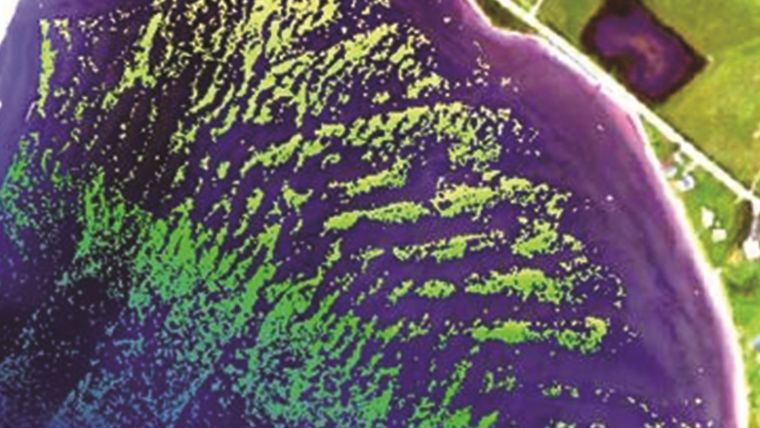
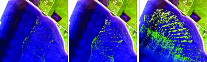
Nova Scotia Community College is validating the Chiroptera 4X bathymetric high-resolution technology in test projects in Canada’s east coast in turbid water conditions. “The four times increased resolution dramatically improves our ability to detect objects, even on a 1m x 1m scale where the increased number of points can be used to further clarify the object's location and details.
Vegetation mapping
"For vegetation mapping, the increased resolution of the sensor provides an unprecedented level of detail related to vegetation and other materials on the seafloor. We have also detected new seabed features not discovered from previous bathy Lidar surveys in the same area, which indicates an increased sensitivity of the solution,” said Tim Webster, research scientist, Applied Geomatics Research Group (AGRG) Centre of Geographic Sciences (COGS), Nova Scotia Community College.
The 4X technology is available as an upgrade package to all current Chiroptera II and HawkEye III customers and will be integrated with all new bathymetric Lidar systems. The improved resolution, depth penetration, and accuracy provide substantial benefit for environmental and coastal monitoring, inland waters mapping, infrastructure planning, and near-shore applications.
Maximising efficiency
Typical end-user specifications require two to four points per square metre for the highest quality level shallow bathymetric Lidar data. This is easily achieved with a single flight line with the Chiroptera 4X or HawkEye 4X shallow channel - in previous generations double coverage was needed. This improvement saves half of the flight costs alone.
With a depth penetration of 2.7/k and collection of 140,000 points per second of the Chiroptera or HawkEye shallow channel, the new 4X technology offers an unmatched shallow water performance in respect to point density, turbid water performance, and depth penetration. For the HawkEye deep channel, the 40,000 points per second collection is market-leading and can easily deliver IHO order 1B data from a single flight line.
“Optimising a bathymetric Lidar system has always been a trade-off between sensitivity (depth penetration) and resolution. Our new 4X high-resolution technology allows us to improve both those parameters without any tradeoffs,” said Anders Ekelund, Hexagon’s Geospatial Content Solutions vice-president of Airborne Bathymetric LiDAR. “Performing advanced high-density site surveying allows users to extract better details for both above-water and underwater features, increasing our knowledge of coastal and inland waterways and habitats.”
For more information, see here.


