Mapping Northwest UK Seabed
The Maritime and Coastguard Agency (MCA, UK) and six partner organisations launched the Ireland, Northern Ireland and Scotland Hydrographic Survey (INIS Hydro) project at the Belfast Harbour Commissioners Office on Monday 4th July 2011. INIS Hydro, which receives GBP3.2 million from the European Union's INTERREG IVA Programme, will produce a standardised hydrographic survey specification and accurate high-resolution bathymetric datasets for seven important seabed areas to the east of Ireland/Northern Ireland and off the west coast of Scotland.
A total of 1400 km2 will be surveyed by the partner organisation's research vessels fitted with multibeam sonar technology.
High-quality bathymetric information is essential for producing accurate navigational charts and for the effective management and conservation of the marine environment. Despite recent technological advances in high-resolution seabed mapping, some 'current' nautical charts still include data from the mid-19th century when depth was measured by lowering lead lines to the seabed at wide intervals.
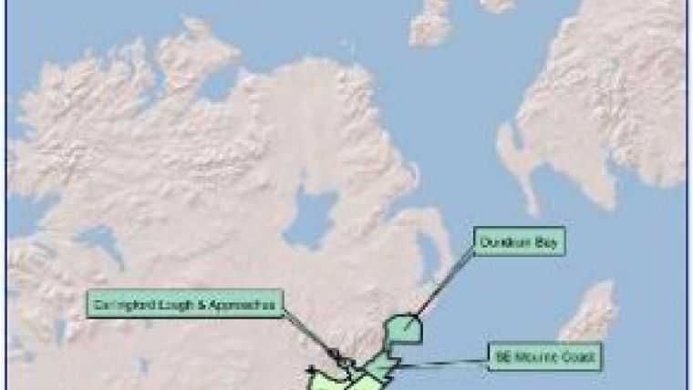
INIS Hydro will survey the Firth of Lorn and the SW Islay Renewables area in Scotland, Dundalk Bay (shallow and deep) in the Republic of Ireland, and Carlingford Lough and Approaches, Dundrum Bay and parts of the Mourn Coast in Northern Ireland. These areas were selected for their environmental significance, suitability for offshore renewables development, and in all cases to update nautical charts.
The project will thus improve safety at sea and provide supportive data to enable effective marine conservation and management, eg relating to fisheries, marine protected areas and marine renewable energy development.
To deliver this project the MCA have teamed up with the Agri-food and Biosciences Institute Northern Ireland, the Geological Survey of Ireland, the Irish Marine Institute, the Scottish Association for Marine Science, the Northern Lighthouse Board and the UK Hydrographic Office.
INIS Hydro follows on from the successful European Union-funded Joint Irish Bathymetric Survey (JIBS) project and receives some match funding from the MCA, the UK Natural Environment Research Council and the Northern Lighthouse Board.
Howard Keery from the Special EU Programmes Body highlighted the expected benefits of the project: "The INIS Hydro project has the potential to provide data that will help the region benefit from natural resources still widely untapped. The coastal and marine area between Ireland, Northern Ireland and Scotland is uniquely positioned and offers access to a wide range of resources. The work developed by this project should make an extremely important contribution towards initiatives in the areas of tourism, renewable energy and marine conservation, which are priority areas identified by the INTERREG IVA Programme."


