Measuring Ocean Winds and Waves from Space
Surrey Satellite Technology (SSTL, UK) has demonstrated a method of measuring winds and waves from space using GNSS reflectometry. This paves the way for a cost-effective satellite system supporting the maritime sector and the organisations that rely on such information. It also offers improvements to weather services and climate research.
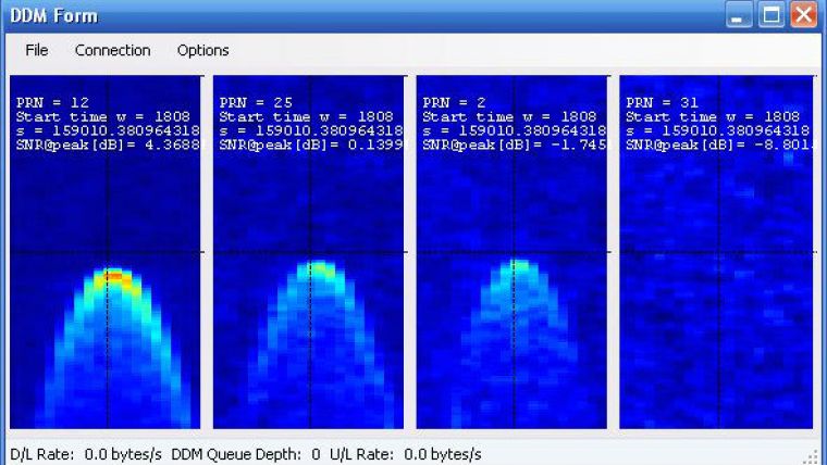
The measurements were taken from an instrument developed by SSTL, the SGR-ReSI, (Space GNSS Receiver Remote Sensing Instrument) that is flying on-board TechDemoSat-1, a technology demonstration satellite which was launched in July 2014. SSTL’s SGR-ReSI collects the signals from GPS and other navigation satellites after they have been reflected off the ocean surface and processes them into images called Delay Doppler Maps (image), from which ocean roughness and wind speed measurements at the sea surface can be interpreted.
The technique works in a similar way to existing scatterometric radar from satellites, however it eliminates the need for a transmitter and can process up to four reflections from different GPS satellites simultaneously, presenting an opportunity for collecting data more regularly and in a denser grid across the globe. By flying the receivers on a constellation of small satellites GNSS Reflectometry data could be used to map all of the Earth’s ocean surface with refreshed data every couple of hours, and this would be of enormous benefit to the maritime industry who depend on wave height and wind speed predictions for optimum ship routing, insurance claims, oil and gas rig operations, undersea cable laying and fishing conditions. Such wind speed and wave height measurements are currently very difficult to make over the open ocean in timely manner and in a dense enough grid to be useful.
Luis Gomes, director of Earth Observation and Science at SSTL, sees a future application of this development which extends the applications of small satellites. A constellation of 18 SGR-ReSIs could cover most of the world’s oceans every few hours providing a real time wind and wave height service. And these do not need to be dedicated satellites as the SGR-ReSI can be easily accommodated as a hosted payload on small satellites with a different primary mission. SSTL’s aim is to deploy such a constellation in the next two years.
The SGR-ReSI can pick up GPS reflections off the ocean and off land, snow and ice, opening up other potential new opportunities for remote sensing – for example, measuring the thickness of sea ice, snow depth, soil moisture levels and the classification of vegetative foliage.
SSTL, with support from the European Space Agency, is preparing the ground processing and web interface that will allow users access to the measurements over the internet with a short delay.
More information, including a Delay Doppler Map from GPS satellites
;
The video shows in about 20 times real time speed the motion of the TechDemoSat-1 satellite over an orbit, indicated by a white cross on the world map. The specular reflections targeted by the SGR-ReSI are shown by yellow spots, and the measurement tracks are shown in yellow. The four Delay Doppler Map channels from the SGR-ReSI are shown at the top right. The spreading horseshoe shape is caused by reflections being received away from the specular point, and a rougher ocean causes more spreading. When reflections are received from over land and over ice, there is much less spreading. The red band on the map indicates the collection of “raw” unprocessed data, which takes a few minutes to transfer before the processed Delay Doppler Maps resume.


